In the predawn hours of a damp May night, a team of seismologists detonated half a ton of explosive slurry, tucked 50 meters below and 200 meters away from them. The ground beneath their feet rumbled, and they saw rocks and water spew from the ground.
At the bottom of a borehole cased with steel, the explosion sent waves of energy through the Earth’s surface, which echoed back from underground rock layers in just under a minute. These echoes were recorded by hundreds of soda bottle–sized seismographs buried underground.
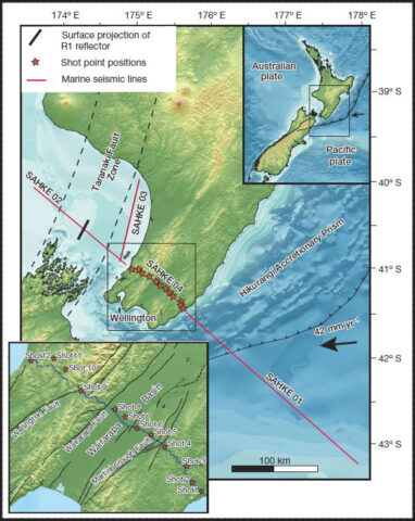
A dozen such boreholes had been drilled and filled with explosives in 2011, spread in a 90-kilometer line across the southern end of New Zealand’s North Island, near the capital city of Wellington. The line of boreholes runs parallel to the diving direction of the Pacific Plate, which is subducting underneath the Australian Plate roughly 25 kilometers below the boreholes.

This explosive experiment was originally intended to image the top of the Pacific Plate, which moves about 9 centimeters per year and threatens Wellington with potentially large earthquakes. However, the data unexpectedly allowed scientists to take an unprecedented peek at the bottom of the subducting slab, 100 kilometers below the boreholes. The new research was published on 5 February in Nature (doi:10.1038/nature14146).
Finding What Lies Below
The behavior of seismic waves in the Earth’s interior can help geoscientists find out what kinds of rocks make up the Earth’s layers and how viscous these rocks are. The speed and direction of these waves change as they propagate through different types of rocks, and those changes can tell scientists about the properties of the rock itself. Earthquake-produced waves, however, are unpredictable and travel long distances, so scientists have turned to creating their own seismic waves with underground explosions.
“This seismic method is much [higher] resolution because we’re shooting from the surface down rather than requiring earthquake waves coming from below” or much farther away, Tim Stern, lead author on the paper and professor of geophysics at Victoria University of Wellington, told Eos.
Similar to the way research vessels use sound waves to image the ocean floor, seismic waves are used to image the Earth’s interior.
Similar to the way research vessels bounce sound waves off the bottom of the ocean to image its mountains and valleys, seismic waves bounce back from rock layers in the Earth’s interior, creating a snapshot of the layers themselves or of different types or densities of rocks within these layers.
The explosion-induced seismic waves reflect back at 5–30 times the frequency of earthquake waves because their wavelengths are much shorter and they travel shorter distances, Stern explained.
A Snapshot of Subduction
Over two nights—to avoid bothering any of the surrounding population—several graduate students a team with explosives licenses detonated all the explosives. By analyzing the reflected waves—or “echoes,” as Stern called them—the team was able to create an image of the bottom layer of the subducting plate. The researchers found that over a 10-kilometer region at the bottom of the plate, the velocity of the waves slowed, indicating that the region was partially melted and weaker than the layers of rock above it.
Stern compared this soft layer to a moving ski on snow—the pressure exerted by the ski creates a thin layer of melted water just underneath the ski that allows for smooth, frictionless movement. Similarly, the layer of partial melt at the bottom of the Pacific Plate allows the plate to slide several centimeters per year.

Theories of Movement
Although the idea that tectonic plates slide around like enormous puzzle pieces on the Earth is widely understood, scientists remain unclear about how the plates actually move.
Two leading theories describe the underlying mechanism of plate tectonics, Stern explained. One is that the plates are coupled with the convection in the mantle and thus feel a downward drag after upward heating cools. The other is that subduction is driven by the pull of the edges of the plates as they sink underneath overlying plates, a process driven by gravity.
Stern said that this new research supports the latter process because the layer of partially melted rock at the base of the subducting plate does not suggest that the hotter, weaker mantle couples with the cooler, more brittle crust in a smooth convection cell.
The melted zone “seems to be a common feature of oceanic planets and what we think is that this [allows] the easy movement of plates across the surface of the Earth,” Stern said. The idea of this easy movement is supported by another study in Norway that found similar signals that indicated a zone of partially melted rock underneath a subducting plate.
More Earth Mysteries
The researchers also found that the transition zone between the rigid lithosphere and softer asthenosphere, which is known as the lithosphere-asthenosphere boundary, is much smaller than previously thought. Previous researchers have found that this transition zone is at least 10 kilometers thick, but Stern’s analysis revealed that it could be as thin as 1 kilometer.
This sharp transition could have implications for the study of mantle dynamics and underlying processes that shape the Earth, said Catherine Rychert, an associate professor of geophysics at the University of South Hampton, in the United Kingdom, who was not involved in the research. She also said that more research must be done to elucidate the origin of the partially melted zone at the edge of the subducting slab and to investigate whether this is a phenomenon found globally.
—JoAnna Wendel, Staff Writer
Citation: Wendel, J. (2015), Pacific plate’s underbelly revealed through explosive means, Eos, 96, doi:10.1029/2015EO023843. Published on 11 February 2015.
Correction, 24 February 2015: An earlier version of the article stated that graduate students detonated the explosives. Instead, a licensed team performed the detonations. Text has been updated to correct this error.
Text © 2015. The authors. CC BY-NC 3.0
Except where otherwise noted, images are subject to copyright. Any reuse without express permission from the copyright owner is prohibited.

