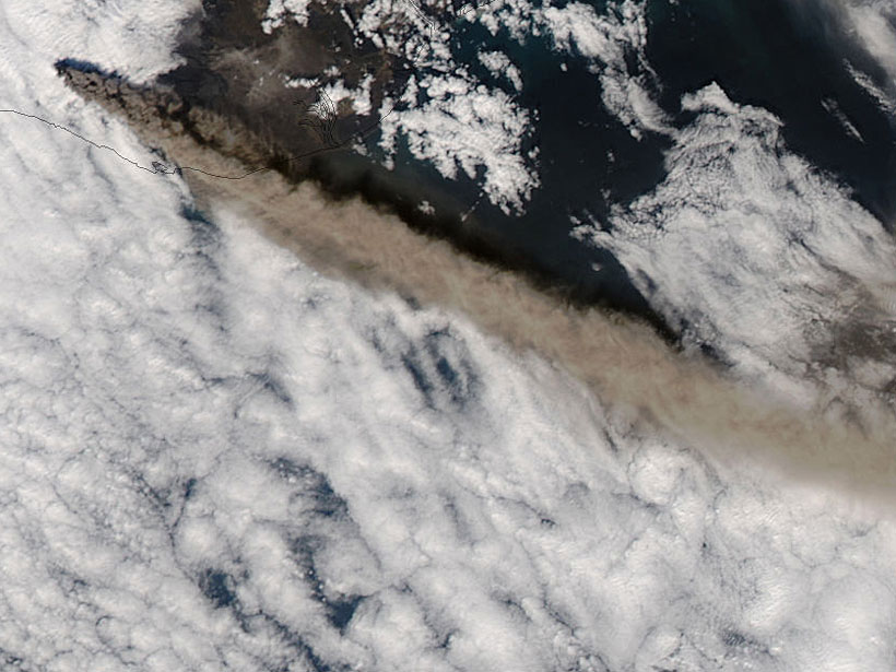
On 14 April 2010, the Icelandic volcano Eyjafjallajökull erupted explosively, hurling volcanic ash several kilometers into the atmosphere. Northerly winds then blew this dense plume toward Europe and the busiest airspace in the world. Over the next 6 days, hundreds of thousands of flights were canceled.
In the first week of the eruption, the closure of European airspace led to losses of approximately 1.3 billion euros (approximately $1.4 billion). In an attempt to stop the hemorrhaging, European aviation regulators turned to models of ash dispersal to determine where the plume was less dense and unlikely to damage airplane engines.
Scientists had only started to develop such models, however, and relied on knowing the intricate details about the eruption to perform the work. “But, in 2010, the amount and quality of the information about ongoing volcanic activity at the beginning of the eruption was quite low,” said volcanologist Sara Barsotti of the Icelandic Meteorological Office.
Moreover, European regulators decided that planes could fly on routes where the ash was below a certain level, but the modelers weren’t confident that their models could deliver the necessary degree of accuracy at each point of the journey, said Larry Mastin, a hydrologist at the U.S. Geological Survey (USGS) in Vancouver, Wash.
The 2010 experience, however, galvanized the community into striving toward creating more powerful models. “It became a technical challenge for the world’s modelers to be able to produce model output during an eruption that has meaningful airborne ash concentrations,” Mastin said.
Shattered Glass
Despite its name, volcanic ash isn’t the remains of burned material, like the ash left after fires. Instead, it is far more deadly.
As magma rises underneath the volcano, tiny bubbles of carbon dioxide and water vapor form in it. When the magma can no longer hold the bubbles, they pop, driving the volcanic eruption. And once the sticky bubble walls reach the atmosphere, they cool into tiny shards of glass, less than a few millimeters in size.
When Eyjafjallajökull erupted, “the whole world changed in terms of how important it was to be able to forecast where ash clouds go.”
Most of the ash from Eyjafjallajökull consisted of these bubble fragments, but ash can also be produced from the shattering of old rock during the eruption or can include mineral fragments that are contained in the magma. The tiny shards of broken bubbles are what typically cause the most damage to humans as well as planes, however.
“If you’re in a place that’s having heavy ashfall, it either forms cement in your lungs, which isn’t good, or it cuts your lungs,” said Erik Klemetti, a volcanologist at Denison University in Granville, Ohio. “As gruesome as it sounds, the deaths from volcanic ash are usually coming from people drowning in their own blood.”
Consequently, in the early 2000s, researchers around the world began to try and forecast where ash traveled or fell after an eruption. While in Italy, Barsotti helped develop the model in 2008, and by 2010, the USGS had developed their own model called Ash3d.
“By April 2010, it was just starting to work, and then of course, Eyjafjallajökull erupted,” said Mastin. “And then the whole world changed in terms of how important it was to be able to forecast where ash clouds go.”
A Meeting of Minds
In the early 1990s, the International Civil Aviation Organization began to set up nine Volcanic Ash Advisory Centers (VAACs) around the world to monitor and provide warnings to aircraft of volcanic ash in their region. Early on, the operators would scan satellite images to look for ash clouds, or once they heard of an eruption, they’d set their own rudimentary models running.
But to accurately model ash dispersal, the VAACs needed vital details on an eruption such as the height of the plume, the time the eruption started, and how long the eruption lasted. Consequently, volcanologists became involved, and the collaborations spurred improvements to the meteorological dispersion models used by most VAACs, along with development of volcano-specific models such as Ash3d.
When trying to determine how far ash travels, a key factor is how much ash is “coming out of the box” during an eruption, a quantity that is correlated with the height of the plume, Mastin said. Another important factor is the grain size of the ash that is being erupted—smaller particles remain aloft longer and can drift farther.
“Having this system in place helps a quick response to an emergency.”
Wind patterns determine how fast and far the ash is transported, requiring the input of hour-by-hour meteorological data at different heights and distances from the volcano. “The way that ashes are dispersed in the atmosphere is pretty complicated,” Mastin said. “It could be blowing in a completely different direction at several kilometers altitude than it is at low altitude.”
The VAACs have their own models, which they use to generate specialized warnings to the aviation community; researchers, volcano observatories, and weather services around the world are able to freely use Ash3d to generate ashfall warnings from eruptions in their region.
In Iceland, researchers now use the Numerical Atmospheric-dispersion Modelling Environment (NAME) ash dispersal model, developed by the UK Met Office integrated into a system that models a range of impacts expected from an eruption. The Icelandic Meteorological Office is continuously running simulations of eruptions of five high-threat volcanoes using current weather conditions with this software. “Having this system in place helps a quick response to an emergency,” Barsotti said.
Onward and Upward
Although researchers have improved their models in the past 12 years, techniques used to monitor many of the features of an eruption have also advanced, which also increases the model’s accuracy, Barsotti said.
Monitoring volcanoes for eruptions is essential to provide timely warnings, and even remote volcanoes that are under air traffic routes need to be monitored, said volcanologist Charles Mandeville, program coordinator of the USGS Volcano Hazards Program.
In March 2019, legislators passed a bill to fund the National Volcano Early Warning System in the United States, which will eventually result in increased monitoring of medium- and high-risk volcanoes in the country. “We have to get much better at optimizing the networks that are out on the volcanoes, to give us the earliest warnings possible,” Mandeville said.
The fact that modelers now have increased access to better quality monitoring data, as well as the opportunity to assimilate the observational data into the models, has improved their forecasts a lot, Barsotti said. But ultimately, the biggest advancements in the past 10 years have come from the collaborations between scientists from many different disciplines.
“The volcanological community is now connected with the meteorological community, for example,” Barsotti said. “These connections will allow us to respond to the next eruption in a more workable and successful way.”
—Jane Palmer (@JanePalmerComms), Science Writer
Citation:
Palmer, J. (2020), The art of volcanic ash modeling 10 years after Eyjafjallajökull, Eos, 101, https://doi.org/10.1029/2020EO142708. Published on 15 April 2020.
Text © 2020. The authors. CC BY-NC-ND 3.0
Except where otherwise noted, images are subject to copyright. Any reuse without express permission from the copyright owner is prohibited.