• About
  • Sections
  • Topics
    • Climate
    • Earth Science
    • Oceans
    • Space & Planets
    • Health & Ecosystems
    • Culture & Policy
    • Education & Careers
    • Opinions
  • Projects
    • ENGAGE
    • Editors’ Highlights
    • Editors’ Vox
    • Eos en Español
    • Eos 简体中文版
    • Print Archive
  • Science Policy Tracker
  • Blogs
    • Research & Developments
    • The Landslide Blog
  • Newsletter
  • Submit to Eos
  • AGU.org
  • Career Center
  • Join AGU
  • Give to AGU
  • About
  • Sections
  • Topics
    • Climate
    • Earth Science
    • Oceans
    • Space & Planets
    • Health & Ecosystems
    • Culture & Policy
    • Education & Careers
    • Opinions
  • Projects
    • ENGAGE
    • Editors’ Highlights
    • Editors’ Vox
    • Eos en Español
    • Eos 简体中文版
    • Print Archive
  • Science Policy Tracker
  • Blogs
    • Research & Developments
    • The Landslide Blog
  • Newsletter
  • Submit to Eos
Skip to content
  • AGU.org
  • Career Center
  • Join AGU
  • Give to AGU
Eos

Eos

Science News by AGU

Support Eos
Sign Up for Newsletter
  • About
  • Sections
  • Topics
    • Climate
    • Earth Science
    • Oceans
    • Space & Planets
    • Health & Ecosystems
    • Culture & Policy
    • Education & Careers
    • Opinions
  • Projects
    • ENGAGE
    • Editors’ Highlights
    • Editors’ Vox
    • Eos en Español
    • Eos 简体中文版
    • Print Archive
  • Science Policy Tracker
  • Blogs
    • Research & Developments
    • The Landslide Blog
  • Newsletter
  • Submit to Eos

Joshua B. Fisher

Surface temperature measurements are shown by orange-red coloration on a satellite image of the Los Angeles area, with South Los Angeles outlined in white and inset images showing closer views of eight different parts of the area.
Posted inScience Updates

A Diverse New Generation of Scientists Observes Earth from Above

by Gregory R. Goldsmith, Monae Verbeke, Jeremy Forsythe and Joshua B. Fisher 16 April 202516 April 2025

Project-based learning and a modular class design help students from various backgrounds and universities gain hands-on experience with environmental remote sensing.

Dry, vegetated landscape near the Santa Clara River in California
Posted inScience Updates

Mapping Vegetation Health Around the World

by Christine M. Lee, Joshua B. Fisher and Simon J. Hook 8 July 202015 October 2021

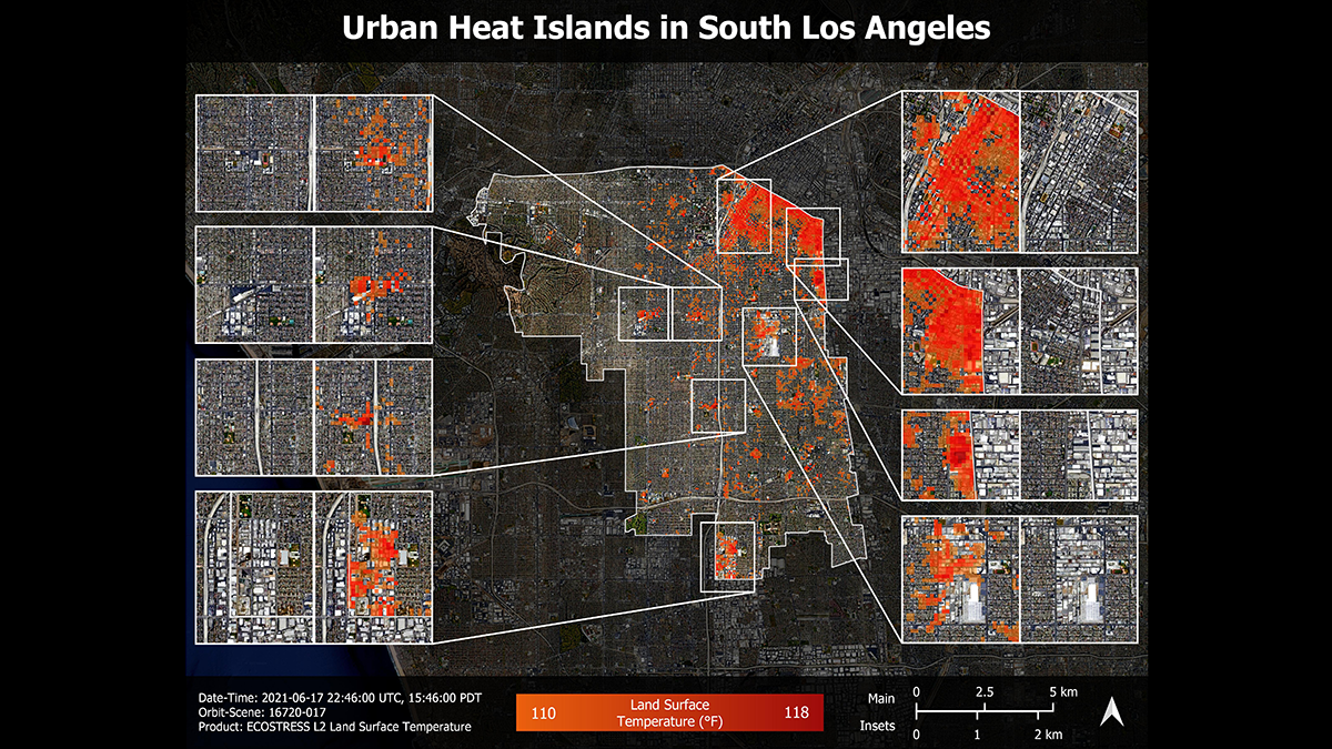
A new spaceborne sensor monitors Earth’s surface temperature at a resolution higher than ever before, providing information on ecosystem responses to changes in water availability and climate stressors.

A view of a bridge, with the New Orleans skyline visible in the distance between the bridge and the water. A purple tint, a teal curved line representing a river, and the text “#AGU25 coverage from Eos” overlie the photo.

Features from AGU Publications

Research Spotlights

Watershed Sustainability Project Centers Place-Based Research

4 December 20254 December 2025
Editors' Highlights

Changes in Slab Dip Cause Rapid Changes in Plate Motion

4 December 20252 December 2025
Editors' Vox

Hydrothermal Circulation and Its Impact on the Earth System

3 December 20253 December 2025
Eos logo at left; AGU logo at right

About Eos
ENGAGE
Awards
Contact

Advertise
Submit
Career Center
Sitemap

© 2025 American Geophysical Union. All rights reserved Powered by Newspack