• About
  • Sections
  • Topics
    • Climate
    • Earth Science
    • Oceans
    • Space & Planets
    • Health & Ecosystems
    • Culture & Policy
    • Education & Careers
    • Opinions
  • Projects
    • ENGAGE
    • Editors’ Highlights
    • Editors’ Vox
    • Eos en Español
    • Eos 简体中文版
    • Print Archive
  • Blogs
    • Research & Developments
    • The Landslide Blog
  • Newsletter
  • Submit to Eos
  • AGU.org
  • Career Center
  • Join AGU
  • Give to AGU
  • About
  • Sections
  • Topics
    • Climate
    • Earth Science
    • Oceans
    • Space & Planets
    • Health & Ecosystems
    • Culture & Policy
    • Education & Careers
    • Opinions
  • Projects
    • ENGAGE
    • Editors’ Highlights
    • Editors’ Vox
    • Eos en Español
    • Eos 简体中文版
    • Print Archive
  • Blogs
    • Research & Developments
    • The Landslide Blog
  • Newsletter
  • Submit to Eos
Skip to content
  • AGU.org
  • Career Center
  • Join AGU
  • Give to AGU
Eos

Eos

Science News by AGU

Support Eos
Sign Up for Newsletter
  • About
  • Sections
  • Topics
    • Climate
    • Earth Science
    • Oceans
    • Space & Planets
    • Health & Ecosystems
    • Culture & Policy
    • Education & Careers
    • Opinions
  • Projects
    • ENGAGE
    • Editors’ Highlights
    • Editors’ Vox
    • Eos en Español
    • Eos 简体中文版
    • Print Archive
  • Blogs
    • Research & Developments
    • The Landslide Blog
  • Newsletter
  • Submit to Eos

Mikaël Attal

Associate Editor, JGR: Earth Surface

On the left is a schematic illustrating the model setup in an idealized rectangular channel. On the right is a contour plot of predicted ratio of lateral erosion rate to vertical erosion rate as a function of transport stage and relative sediment supply.
Posted inEditors' Highlights

Impacts by Moving Gravel Cause River Channels to Widen or Narrow

by Mikaël Attal 24 September 202115 February 2023

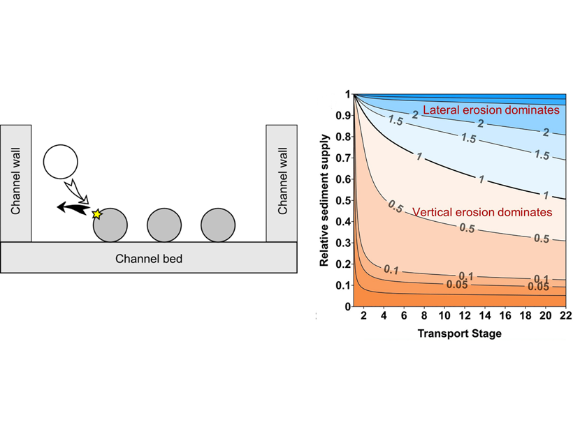
A new analytical model describes how the amount and grain size of sediment transported by rivers influences bedrock channel width, which can be used to predict where rivers will widen or narrow.

Charts showing relationship between catchment-averaged erosion rate and landscape steepness index
Posted inEditors' Highlights

Meteoric 10Be Reveals Lithological Control on Erosion Rates

by Mikaël Attal 1 June 202026 January 2023

New meteoric 10Be data quantify fast erosion of slates in the Zhuoshui River catchment in Taiwan and demonstrate the influence of lithology on landscape steepness.

Simulated depths around Tuting village
Posted inEditors' Highlights

Enabling Dynamic, Regional-Scale Modelling of Outburst Floods

by Mikaël Attal 7 May 201924 February 2022

The GeoClaw model is used to simulate a landslide-dam outburst flood through rugged Himalayan topography.

Posts pagination

Newer posts 1 2
A view of a Washington, D.C., skyline from the Potomac River at night. The Lincoln Memorial (at left) and the Washington Monument (at right) are lit against a purple sky. Over the water of the Potomac appear the text “#AGU24 coverage from Eos.”

Features from AGU Publications

Research Spotlights

Early Apes Evolved in Tropical Forests Disturbed by Fires and Volcanoes

12 June 202511 June 2025
Editors' Highlights

Kuroshio Intrusions into Luzon Strait Increase Chlorophyll

11 June 202510 June 2025
Editors' Vox

Rising Concerns of Climate Extremes and Land Subsidence Impacts

9 June 20254 June 2025
Eos logo at left; AGU logo at right

About Eos
ENGAGE
Awards
Contact

Advertise
Submit
Career Center
Sitemap

© 2025 American Geophysical Union. All rights reserved Powered by Newspack