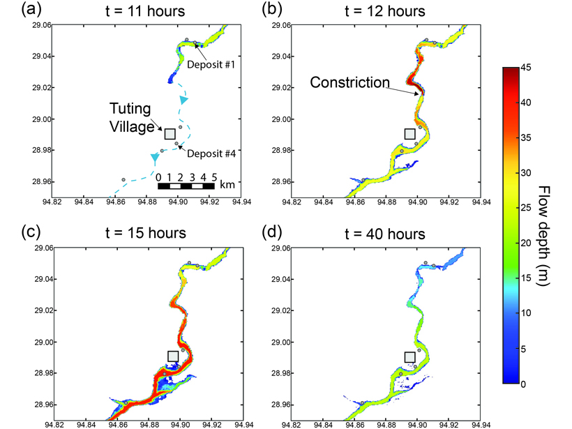
Source: Journal of Geophysical Research: Earth Surface
An outburst flood is the sudden release of vast amounts of water as a natural dam (such as a landslide or a moraine dam) fails. Because a surge wave can travel hundreds of kilometers, outburst floods represent a major hazard in mountainous landscapes and beyond.
Most existing 2D models which can produce realistic simulations of outburst floods (by taking into account the complex interactions between the flow and the landscape) would take far too long to run over large areas. The open source software GeoClaw overcomes this problem by allowing the mesh of the model to change as the flood progresses through the landscape: at each time step, the resolution increases in the zones of greatest interest (such as the front of the propagating flood wave), allowing the model to optimize efficiency and predict the dynamics of the flood over hundreds of km in a reasonable amount of time.
Turzewski et al. [2019] demonstrate the performance of GeoClaw by modeling the second largest historical landslide-dam outburst flood on record: the Yigong River outburst flood that occurred in June 2000. They show that flood timing is very sensitive to parameters such as roughness, but flood extent and depths are not.

Simulated flood extent immediately downstream of the dam breach for the first 8 hours after the breach (time is in seconds). The frame is about 20 km wide. Elevation is given by gray shade and flow depth by colours. Note how the pixel size changes to allow faster calculations and greater resolution in the zone of interest (along the flow path). Credit: Turzewski et al. [2019], Supporting Information, Movie S1
GeoClaw produces reliable flood maps, consistent with the mapping of geomorphic markers in the field. GeoClaw could therefore represent a cutting-edge tool for outburst flood risk management, with the option of using the worst-case scenario if timing is vital. GeoClaw can also be used to better understand landscape evolution during extreme floods in mountains, as it can predict how shear stress and Froude number—two variables that control erosion and sediment deposition—vary along the river during the flood.
Citation: Turzewski, M. D., Huntington, K. W., & LeVeque, R. J. [2019]. The geomorphic impact of outburst floods: Integrating observations and numerical simulations of the 2000 Yigong flood, eastern Himalaya. Journal of Geophysical Research: Earth Surface, 124. https://doi.org/10.1029/2018JF004778
—Mikael Attal, Associate Editor, JGR: Earth Surface
Text © 2019. The authors. CC BY-NC-ND 3.0
Except where otherwise noted, images are subject to copyright. Any reuse without express permission from the copyright owner is prohibited.

