• About
  • Sections
  • Topics
    • Climate
    • Earth Science
    • Oceans
    • Space & Planets
    • Health & Ecosystems
    • Culture & Policy
    • Education & Careers
    • Opinions
  • Projects
    • ENGAGE
    • Editors’ Highlights
    • Editors’ Vox
    • Eos en Español
    • Eos 简体中文版
    • Print Archive
  • Science Policy Tracker
  • Blogs
    • Research & Developments
    • The Landslide Blog
  • Newsletter
  • Submit to Eos
  • AGU.org
  • Career Center
  • Join AGU
  • Give to AGU
  • About
  • Sections
  • Topics
    • Climate
    • Earth Science
    • Oceans
    • Space & Planets
    • Health & Ecosystems
    • Culture & Policy
    • Education & Careers
    • Opinions
  • Projects
    • ENGAGE
    • Editors’ Highlights
    • Editors’ Vox
    • Eos en Español
    • Eos 简体中文版
    • Print Archive
  • Science Policy Tracker
  • Blogs
    • Research & Developments
    • The Landslide Blog
  • Newsletter
  • Submit to Eos
Skip to content
  • AGU.org
  • Career Center
  • Join AGU
  • Give to AGU
Eos

Eos

Science News by AGU

Support Eos
Sign Up for Newsletter
  • About
  • Sections
  • Topics
    • Climate
    • Earth Science
    • Oceans
    • Space & Planets
    • Health & Ecosystems
    • Culture & Policy
    • Education & Careers
    • Opinions
  • Projects
    • ENGAGE
    • Editors’ Highlights
    • Editors’ Vox
    • Eos en Español
    • Eos 简体中文版
    • Print Archive
  • Science Policy Tracker
  • Blogs
    • Research & Developments
    • The Landslide Blog
  • Newsletter
  • Submit to Eos

CC BY-NC-ND 2019

Photo of a river limned by marshlands
Posted inResearch Spotlights

Tracking Dissolved Organic Matter in Coastal Ecosystems

Elizabeth Thompson by Elizabeth Thompson 6 June 201926 March 2024

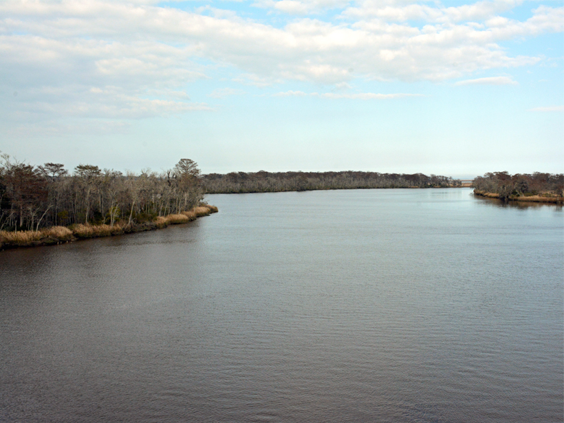
Dissolved organic matter supports aquatic food webs and holds as much carbon as the atmosphere. A new study tracks which sources and processes play the biggest role in coastal systems.

Distorted railway lines at the North Anatolian Fault due to the 1999 earthquake Aykut Barka
Posted inResearch Spotlights

Variations in Creep Along One of Earth’s Most Active Faults

by Terri Cook 6 June 201918 April 2022

Satellite-based radar images of motion along Turkey’s North Anatolian Fault are helping scientists understand when, where, and how creep occurs and its implications for seismic hazard.

Aerial view of the Swiss Alps
Posted inResearch Spotlights

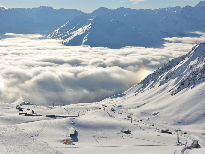
Using GPS Sensors to Capture Key Snowpack Properties

Sarah Stanley, Science Writer by Sarah Stanley 6 June 201928 July 2022

A low-cost, two-antenna GPS setup could enable valuable snow measurements in remote locations, improving predictions of runoff and avalanche risk.

Figure showing changes in ocean surface temperature as a large iceberg and several small icebergs break off an ice shelf
Posted inEditors' Highlights

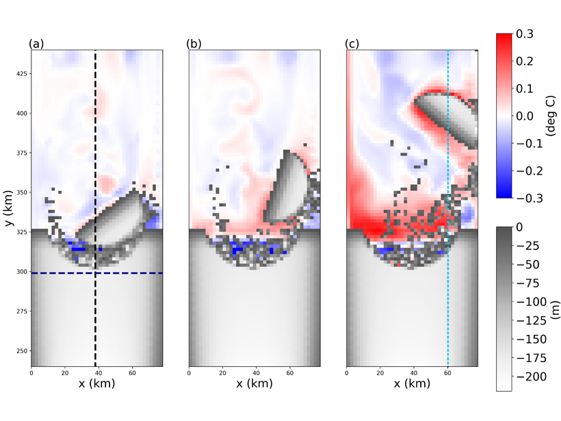
Creating Icebergs in Ocean Models Coupled to Ice Shelves

by L. Padman 6 June 201923 March 2023

Modeling icebergs as Lagrangian elements held together by numerical bonds provides insights into coupled exchanges of heat, freshwater, and momentum between large icebergs and the ocean.

Satellite image of clouds swirling above Earth
Posted inResearch Spotlights

The Tropical Atmosphere’s Balancing Act

by E. Underwood 5 June 20196 March 2023

A new study finds that the tropical atmosphere maintains radiative-convective equilibrium as a whole, but not at smaller scales.

Herders and their yaks in the Nyainqêntanglha mountain range in central Tibet
Posted inResearch Spotlights

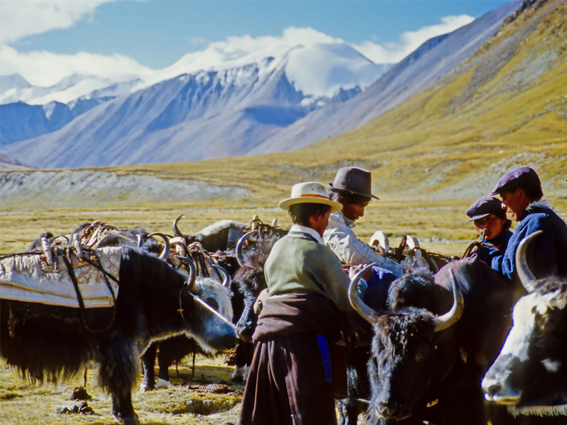
Mountain Ecosystems and Communities Face Challenges Worldwide

Sarah Stanley, Science Writer by Sarah Stanley 5 June 20191 March 2023

An unprecedented global assessment examines climate, economic, and governance threats to mountain systems and the benefits they provide, suggesting pathways toward sustainability.

Satellite image of a city between a volcano and a lake
Posted inNews

Eruption in El Salvador Was One of the Holocene’s Largest

Katherine Kornei, Science Writer by Katherine Kornei 5 June 201922 August 2023

Roughly 1,500 years ago, the Tierra Blanca Joven eruption blanketed Central America in ash and likely displaced Maya settlements, new research shows.

Figure showing first transect of radiocarbon in DOC with depth below the ocean surface in the Pacific Ocean, as a function of latitude
Posted inEditors' Highlights

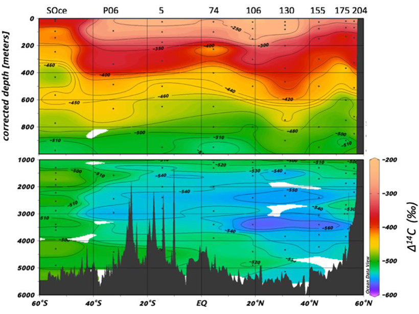
Pacific Carbon Ages During Long Journey Along Ocean Floor

by Rose Cory 4 June 201927 September 2022

The radiocarbon signal of DOC with depth across the Pacific Ocean basin effectively supports a number of important theories that have been suggested over the years.

The Maldives as seen from a drone.
Posted inResearch Spotlights

Sea Level Rise May Reactivate Growth of Some Reef Islands

Sarah Stanley, Science Writer by Sarah Stanley 4 June 201911 February 2022

Reconstruction of reef island formation in the Maldives suggests the possibility that not all islands will shrink as climate change progresses.

The Polar 6 research airplane in Antarctica
Posted inResearch Spotlights

Missing Lakes Under Antarctic Ice Sheets

by E. Underwood 4 June 201928 July 2022

New radio sounding study finds little evidence of lakes under Antarctica’s Recovery Glacier.

Posts pagination

Newer posts 1 … 30 31 32 33 34 … 66 Older posts
A view of a Washington, D.C., skyline from the Potomac River at night. The Lincoln Memorial (at left) and the Washington Monument (at right) are lit against a purple sky. Over the water of the Potomac appear the text “#AGU24 coverage from Eos.”

Features from AGU Publications

Research Spotlights

Satellite Scans Can Estimate Urban Emissions

6 October 20256 October 2025
Editors' Highlights

New Evidence for a Wobbly Venus?

29 September 202525 September 2025
Editors' Vox

All Publish, No Perish: Three Months on the Other Side of Publishing

29 September 202525 September 2025
Eos logo at left; AGU logo at right

About Eos
ENGAGE
Awards
Contact

Advertise
Submit
Career Center
Sitemap

© 2025 American Geophysical Union. All rights reserved Powered by Newspack