• About
  • Sections
  • Topics
    • Climate
    • Earth Science
    • Oceans
    • Space & Planets
    • Health & Ecosystems
    • Culture & Policy
    • Education & Careers
    • Opinions
  • Projects
    • ENGAGE
    • Editors’ Highlights
    • Editors’ Vox
    • Eos en Español
    • Eos 简体中文版
    • Print Archive
  • Blogs
    • Research & Developments
    • The Landslide Blog
  • Newsletter
  • Submit to Eos
  • AGU.org
  • Career Center
  • Join AGU
  • Give to AGU
  • About
  • Sections
  • Topics
    • Climate
    • Earth Science
    • Oceans
    • Space & Planets
    • Health & Ecosystems
    • Culture & Policy
    • Education & Careers
    • Opinions
  • Projects
    • ENGAGE
    • Editors’ Highlights
    • Editors’ Vox
    • Eos en Español
    • Eos 简体中文版
    • Print Archive
  • Blogs
    • Research & Developments
    • The Landslide Blog
  • Newsletter
  • Submit to Eos
Skip to content
  • AGU.org
  • Career Center
  • Join AGU
  • Give to AGU
Eos

Eos

Science News by AGU

Support Eos
Sign Up for Newsletter
  • About
  • Sections
  • Topics
    • Climate
    • Earth Science
    • Oceans
    • Space & Planets
    • Health & Ecosystems
    • Culture & Policy
    • Education & Careers
    • Opinions
  • Projects
    • ENGAGE
    • Editors’ Highlights
    • Editors’ Vox
    • Eos en Español
    • Eos 简体中文版
    • Print Archive
  • Blogs
    • Research & Developments
    • The Landslide Blog
  • Newsletter
  • Submit to Eos

CC BY-NC-ND 2020

A satellite image showing a pumice raft floating on the ocean surface near Fiji and Tonga on 21 August 2019
Posted inScience Updates

Satellite Sleuthing Detects Underwater Eruptions

by P. A. Brandl 31 March 202018 January 2022

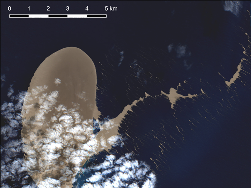
Satellite data helped scientists locate the volcanic source of a pumice raft floating in the South Pacific Ocean, illustrating their promise in locating and monitoring undersea eruptions.

Chart showing mercury stable isotope concentrations in tree rings
Posted inEditors' Highlights

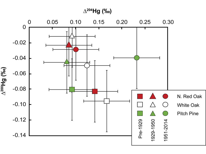
Trees Are Watching Us and Our Actions

by Ankur R. Desai 31 March 20205 May 2022

Annual growth rings in trees tell us more than climate history; they can also document the rise and fall of human industrial activities.

Illustration of Stone Age villagers shading their eyes from a nearby airburst
Posted inNews

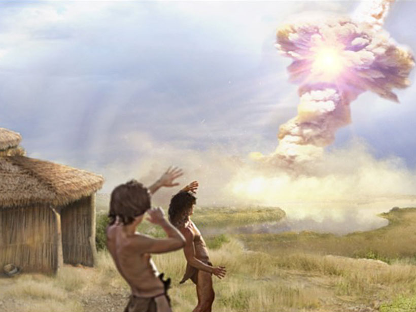
Armageddon at 10,000 BCE

Javier Barbuzano, Science Writer by Javier Barbuzano 30 March 20202 February 2022

Fragments of a comet likely hit Earth 12,800 years ago, and a little Paleolithic village in Syria might have suffered the impact.

Glaciologist Erin Pettit, in a bandana and sunglasses, smiles from the door of a tent in Antarctica.
Posted inNews

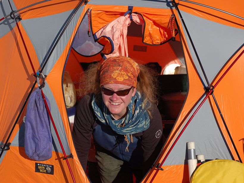
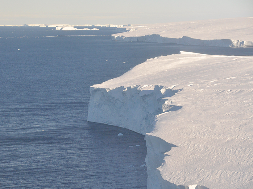
Erin Pettit: Glaciologist, Artist, Mentor

Katherine Kornei, Science Writer by Katherine Kornei 30 March 202013 December 2021

Between research trips to Antarctica and the Arctic, Pettit regularly leads art- and science-focused wilderness expeditions for young women.

Schematic showing two independent methods used to estimate the change in CO2 fluxes due to widespread flooding across the U.S. Midwest region in spring and summer 2019.
Posted inEditors' Highlights

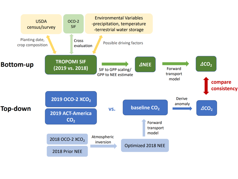
Toward Forecasting Crop Productivity and Carbon Flux Anomalies

Eric Davidson, president-elect of AGU by Eric Davidson 27 March 202020 October 2021

Quantifying reductions in U.S. Midwest crop productivity and carbon uptake due to 2019 flooding using combined satellite observations of solar-induced chlorophyll fluorescence and atmospheric CO2.

Two dozen alligators gather in clusters in a swampy area of Everglades National Park
Posted inFeatures

Lost in the Everglades

Mary Caperton Morton, Science Writer by Mary Caperton Morton 27 March 202029 September 2021

Living in Geologic Time: An unintentional adventure in the River of Grass shows how Florida has changed dramatically over 15,000 years of human habitation.

Thwaites glaciar
Posted inNews

“Terremotos Glaciales” Vistos por Primera Vez en Thwaites

Katherine Kornei, Science Writer by Katherine Kornei 26 March 202013 January 2022

Estos eventos sísmicos, provocados por los icebergs que se vuelcan y chocan contra Thwaites, revelan que el glaciar ha perdido parte de su plataforma flotante de hielo.

Aerial photo of a ship in an oil slick
Posted inNews

Leveraging Satellite Sensors for Oil Spill Detection

Sarah Derouin, Science Writer by Sarah Derouin 26 March 202018 May 2022

By using multiple remote sensors, scientists can quickly estimate the nature and thickness of oil spills—important factors for containment efforts.

Ears of corn wither on parched stalks
Posted inNews

Predicting Fast Moving Flash Droughts

Mary Caperton Morton, Science Writer by Mary Caperton Morton 26 March 202018 February 2022

A cross-disciplinary consortium of scientists works to monitor droughts that develop in as little as 2 weeks—whose frequencies are predicted to increase with climate change.

Candidatus Macondimonas diazotrophica visible both inside and around the edges of oil droplets
Posted inFeatures

Deepwater Horizon and the Rise of the Omics

by J. Kostka, S. B. Joye and Rita R. Colwell 25 March 202018 May 2022

Microbial genomics techniques came of age following the Deepwater Horizon spill, offering researchers unparalleled insights into how ecosystems respond to such environmental disasters.

Posts pagination

Newer posts 1 … 43 44 45 46 47 … 57 Older posts
A view of a Washington, D.C., skyline from the Potomac River at night. The Lincoln Memorial (at left) and the Washington Monument (at right) are lit against a purple sky. Over the water of the Potomac appear the text “#AGU24 coverage from Eos.”

Features from AGU Publications

Research Spotlights

Tracing Black Carbon’s Journey to the Ocean

11 July 202510 July 2025
Editors' Highlights

The Power of Naming Space Weather Events

10 July 20258 July 2025
Editors' Vox

Water Tracks: The Veins of Thawing Landscapes

25 June 202525 June 2025
Eos logo at left; AGU logo at right

About Eos
ENGAGE
Awards
Contact

Advertise
Submit
Career Center
Sitemap

© 2025 American Geophysical Union. All rights reserved Powered by Newspack