Editors’ Highlights are summaries of recent papers by AGU’s journal editors.
Source: Journal of Geophysical Research: Earth Surface
Quantifying sediment flux from mountains to low-lying areas is important for river management and hazard mitigation. High sediment fluxes can lead to increased flood risk due to rivers raising their beds, as well as siltation of reservoirs and dams. Estimates of sediment fluxes can also tell us how quickly landscapes are eroding, which can help identify erosion hot-spots. Such hot-spots can then be related to mountain building processes and associated hazards such as earthquakes and landslides.
In addition, being able to compare modern (yearly to decadal) and long-term (millennial) sediment fluxes can help answering important questions regarding the impact of human activities (such as land use changes and dam building) and climate change on erosion and on the amount of sediment transported by rivers. For example: is deforestation leading to increased erosion rates and sediment fluxes? However, while it is relatively easy to measure modern sediment fluxes by measuring the concentration of suspended sediment in rivers, measuring long-term fluxes is more challenging.
Over the past couple of decades, a new technique based on cosmogenic radionuclides (CRN) has led to breakthroughs, providing erosion rates averaged over millennia. CRN are rare atoms that do not exist in rocks at depth. As soon as a rock is brought near the surface, CRN start accumulating in the rock due to interactions between the atoms that make up the rock and the cosmic rays that continually bombard the surface of the Earth. The longer a rock is exposed near the surface of the Earth, the greater its concentration in CRN. When erosion is slow, rocks spend a lot of time near the surface of the Earth: they accumulate a lot of CRN before being broken down into fragments that are then transported by rivers. Conversely, rocks spend little time near the surface of the Earth in fast eroding landscapes, and rock fragments will contain little CRN. The concentration of CRN in river sand can therefore be used to tell how quickly the area upstream of a sample location is eroding: the faster the erosion, the lower the CRN concentration.
While the technique works well when new rocks are freshly exposed for the first time over geological timescales, it doesn’t work well when the rocks that are being brought to the surface are made of fragment of rocks that have only been deposited and buried in the recent geological past (last few million years), such as recent sedimentary rocks laid down by rivers. Indeed, such rocks may still contain CRNs inherited from their previous history.
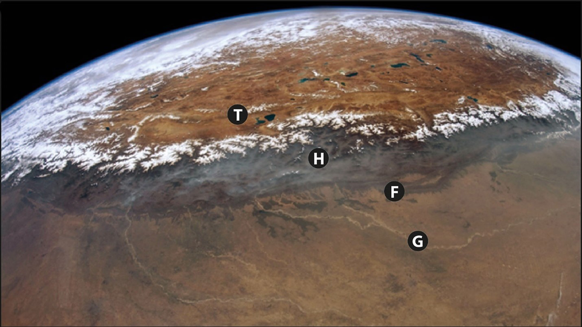
The Himalaya can be broadly divided in the High Himalaya that make up the bulk of the mountain range, and the Frontal Ranges where sediment deposited in the past few million years is being pushed upwards and exposed again to erosion (see figure above). In the High Himalaya, rocks are freshly exposed for the first time and CRN concentrations in river sand will reflect erosion rates upstream of the point of sampling; as a result, we have a lot of information on erosion rates in the High Himalaya. Once rivers cross the Frontal Ranges, they start incorporating sediment that is “recycled” and may contain CRN inherited from its previous history before deposition, rendering the interpretation of CRN highly unreliable; as a result, we have very little information about the erosion rates of the Frontal Ranges.
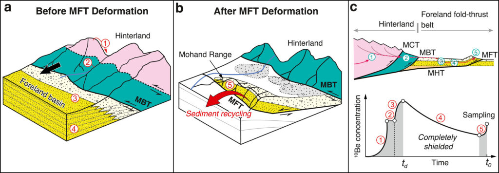
In their study, Mandal et al. [2023] overcome the problems associated with sediment recycling and turn it to their advantage. By combining CRN concentrations in rivers upstream and downstream of the Frontal Ranges with unique information about (1) the geometry of the Frontal Ranges and of the faults that lead to their growth, (2) the rates at which India is converging towards Asia, and (3) the age of the different rock units that make up the Frontal Ranges, they are able for the first time to estimate the amount of CRN that is inherited in their samples, and therefore to estimate the erosion rates in the Frontal Ranges. Based on this information, they show that the erosion of these ranges contributes 21 ± 5% of the overall sediment flux to the low-lying Ganga Plain in their study area. This work shows that sediment recycling may not always be a curse, and that the Frontal Ranges represent a major source of sediment to the Ganga Plains.
Citation: Mandal, S. K., Kapannusch, R., Scherler, D., Barnes, J. B., Insel, N., & Densmore, A. L. (2023). Cosmogenic nuclide tracking of sediment recycling from a Frontal Siwalik range in the northwestern Himalaya. Journal of Geophysical Research: Earth Surface, 128, e2023JF007164. https://doi.org/10.1029/2023JF007164
—Mikael Attal, Editor, JGR: Earth Surface