Source: Journal of Geophysical Research: Earth Surface
Future climate projections indicate an increasing likelihood of extreme precipitation in many regions globally. Much of the western United States saw extreme wet conditions in winter 2017, providing opportunities to study geomorphic response to a scenario likely to repeat more frequently in the future.
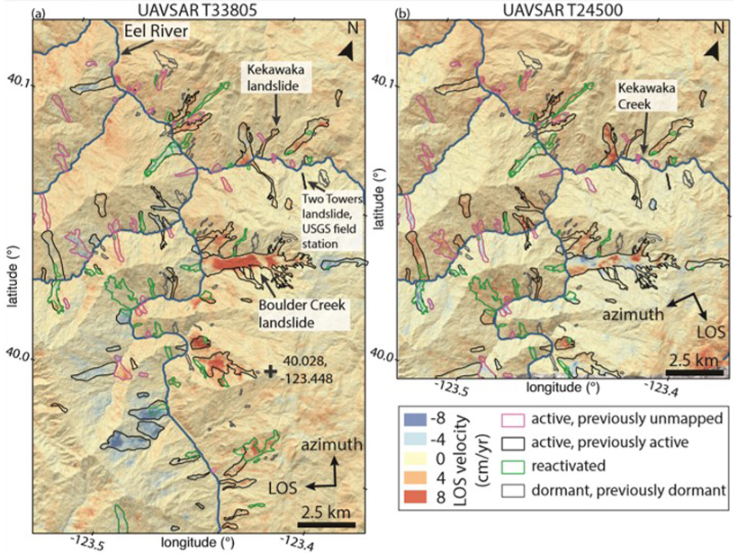
Building on earlier investigations of slow-moving landslides in northern California, Handwerger et al. [2019] employed a novel Uninhabited Aerial Vehicle Synthetic Aperture Radar (UAVSAR) dataset to map hundreds of slow-moving landslides, and estimated changes in velocity inferred to have resulted from changes in rainfall over three water years (2016–2018). By tracking landslide motion from the end of a historic drought through extreme wet conditions and back to subsequent below-average rainfall, the authors found that landslide velocity and the number of active slides clearly tracked large changes in annual precipitation. Smaller, thinner landslides were especially sensitive to annual rainfall changes, as those landslides undergo larger changes in basal pore-water pressure.
These results suggest that, as California experiences more-frequent extreme wet years and more-frequent dry-to-extreme-wet transitions over the twenty-first century, there will be an overall increase in landslide activity. Moreover, such applications of rapid, high-resolution and large-spatial-domain remote-sensing techniques have the potential to revolutionize landslide studies.
Citation: Handwerger, A. L., Fielding, E. J., Huang, M.‐H., Bennett, G. L., Liang, C., & Schulz, W. H. [2019]. Widespread initiation, reactivation, and acceleration of landslides in the northern California Coast Ranges due to extreme rainfall. Journal Geophysical Research: Earth Surface, 124. https://doi.org/10.1029/2019JF005035
—Amy East, Editor in Chief, JGR: Earth Surface
Text © 2019. The authors. CC BY-NC-ND 3.0
Except where otherwise noted, images are subject to copyright. Any reuse without express permission from the copyright owner is prohibited.