Source: Journal of Geophysical Research: Atmospheres
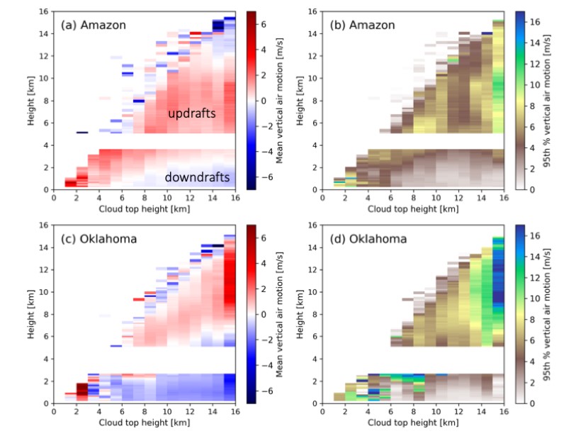
Among the largest and most intense convective storms, mesoscale convective systems (MCSs) are often recognized for their extreme precipitation potential. One of the most fundamental properties of thunderstorms is the vertical air motion, in the form of up- and downdrafts. Wang et al. [2019] present a unique multi-year dataset from relatively cost-effective radar wind profilers, operated by the United States Department of Energy Atmospheric Radiation Measurement Climate Research Facility, to provide a comprehensive description of updrafts and downdrafts, contrasting midlatitude (Oklahoma, USA) and tropical (Amazon basin, Brazil) examples. They find that systems in both locations often share similar convective rainfall rates and total rainfall accumulations. However, the midlatitude MCSs are associated with the more intense convective updrafts with upward air motions peaking at higher altitudes. The most pronounced contrast is the propensity for more frequent, intense, and deeper downdrafts in the midlatitude MCS events.
Citation: Wang, D., Giangrande, S. E., Schiro, K., Jensen, M. P., & Houze, R. A. [2019]. The characteristics of tropical and midlatitude mesoscale convective systems as revealed by radar wind profilers. Journal of Geophysical Research: Atmospheres, 124. https://doi.org/10.1029/2018JD030087
—Minghua Zhang, Editor in Chief, JGR: Atmospheres
Text © 2019. The authors. CC BY-NC-ND 3.0
Except where otherwise noted, images are subject to copyright. Any reuse without express permission from the copyright owner is prohibited.