Soil moisture is the most important hydrologic state variable that directly impacts the global environment and human society. In recognition of its significance, soil moisture has been included in the list of the most fundamental climate variables by the Global Climate Observing System initiative that is co-sponsored by the World Meteorological Organization. A recent article in Reviews of Geophysics explores the latest advances in measurement and monitoring of soil moisture from the pedon to the global scales and discusses opportunities for future research. Here, the authors of the paper answer some questions about basic concepts and methodological developments in this field.
Why is knowledge about soil moisture so important?
Knowledge about soil moisture and its spatial and temporal variations across scales has numerous Earth and environmental science applications.
In-depth knowledge about soil moisture and its spatial and temporal variations across scales is essential for numerous Earth and environmental science applications.
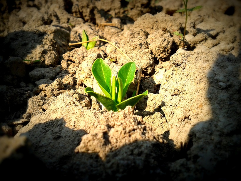
For example, crop production relies on soil moisture information for irrigation management to increase yields, but also for the mitigation of adverse environmental impacts due to over-irrigation as well as for the conservation of water resources.
The latter is especially important in view of the water crisis and prolonged drought conditions in many arid and semiarid regions of the world that is expected to further escalate due to the rapidly growing human population and the changing global climate.
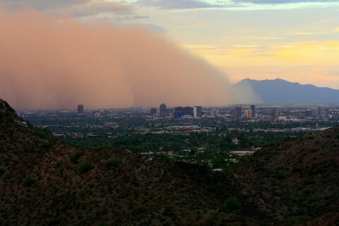
Another area of application is the impact mitigation of natural disasters such as wildfires, landslides, floods or dust storms since the likelihood of their occurrence is intimately linked to the moisture status of the land surface.
For example, when the soil moisture diminishes below a certain threshold (i.e., the soil surface dries out) on land with sparse vegetation and the atmospheric conditions are favorable (i.e., strong winds and low relative humidity), a dust storm or so-called “haboob” may develop.
Over the past decade, the dust storm occurrence frequency in the Southwestern United States has exhibited an upward trajectory, causing chronic breathing and cardiovascular problems for humans, and exposing both humans and animals to fungal spores that can lead to potentially fatal valley fever (coccidioidomycosis).
Other important applications of soil moisture information include forecasting of weather and climate variability, projection and monitoring of drought conditions, management and allocation of water resources, or monitoring of ecosystem response to climate change, to name just a few.
How is soil moisture measured and what are some of the most recent technological advances?
Today, a growing number of techniques are available to measure and monitor the spatial and temporal variability of soil moisture.
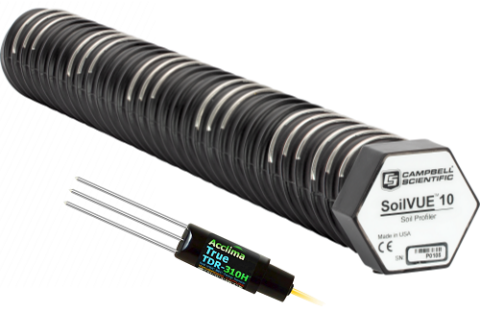
At the pedon scale, electromagnetic soil moisture sensors based on the time domain reflectometry (TDR), impedance, or capacitance measurement principles are deployed to capture and record soil moisture changes. The latest generation of sensors incorporate microelectronic measurement circuitry together with a microprocessor directly in the sensor head and communicate processed data to a datalogger. These sensors can be integrated into large wireless networks to extend their spatial coverage to the field and catchment scales.

The cosmic-ray neutron probe (CRNP) is another promising invention that infers soil moisture for an about 300-meter circular footprint from counting neutrons generated when cosmic rays interact with the topsoil.
There is also a growing number of geophysical sensing methods such as ground penetrating radar (GPR), ground-based radiometer and radar systems, electromagnetic induction (EMI), and magnetic resonance imaging (MRI) deployed for field scale determination of soil moisture dynamics.
The above-mentioned smaller scale measurements are often used as a reference for the calibration of large scale (i.e., regional to global) air- and spaceborne remote sensing (RS) techniques that provide an exceedingly powerful means for characterization and monitoring of near-surface soil moisture.

Meanwhile, the application of Unmanned Aerial Systems (UAS) as decision support for precision agriculture irrigation and crop health management has lately gained a lot of momentum due to the technological developments and cost reductions of UAS platforms and associated imaging hardware.
There is also an increase in satellite remote sensing applications with steadily improving spatial and temporal resolutions.
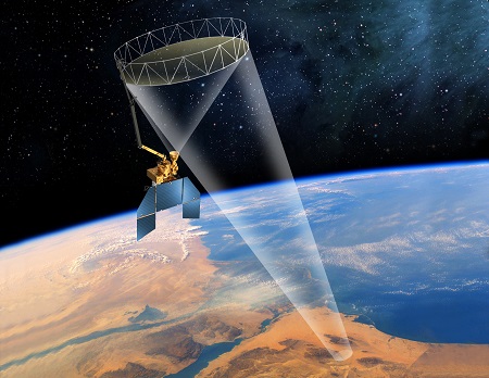
Instruments such as the Japan Aerospace Exploration Agency (JAXA) Advanced Microwave Scanning Radiometer (AMSR-E on NASA’s Aqua satellite and AMSR-2 on the GCOM-W1 satellite), the European Organization for the Exploitation of Meteorological Satellites (EUMETSAT) Advanced SCATterometer (ASCAT), the European Space Agency (ESA) Soil Moisture and Ocean Salinity (SMOS), the NASA Aquarius, the NASA Soil Moisture Active Passive (SMAP), and the ESA Sentinel-1 have been dedicated to the measurement of land surface soil moisture at reasonable temporal and spatial resolutions over the past decade.
What are the remaining challenges in gathering soil moisture data and what unresolved questions require additional research?
Despite all the exciting recent advances in soil moisture measurement capabilities, further research is needed to enhance and optimize technology and to develop analysis and retrieval methods.
Despite all the exciting recent advances in soil moisture measurement capabilities, further research is needed to enhance and optimize technology and to develop analysis and retrieval methods.
While the booming electromagnetic sensor market provides an exceedingly vast array of differently priced sensors of various qualities and measurement accuracies, there are currently no unified testing and performance standards. Such uniform standards and testing methods are critically needed for sensor comparison and for the choice of the best suitable sensors for specific measurement tasks.
Within the realm of coarser-scale airborne and satellite soil moisture remote sensing applications, challenges with their validation and calibration based on ground reference measurements persist due to the disconnect between the sensing depth of ground and remote sensors and the scaling disparity between their measurement footprints. As with electromagnetic sensors, there is a need to develop standardized validation methods that consider the scale and sensing depth mismatch. In addition, appropriate scaling techniques need to be developed to enhance the applicability of satellite soil moisture observations for precision agriculture and other field scale applications.
Finally, a remaining grand remote sensing challenge is the accurate estimation of root-zone soil moisture from the remotely sensed near-surface soil moisture information. The most commonly applied technique for retrieving root-zone soil moisture from satellite remote sensing is assimilation of near-surface measurements into, for example, land surface or crop growth models. Further information such as groundwater table depth, highly spatially resolved soil data and remotely sensed crop information should be considered for constraining the root-zone soil moisture estimates. In addition, improved characterizations of subsurface processes that control the status of root-zone soil moisture are necessary to remove model estimation biases and to further decrease estimation uncertainty.
—Markus Tuller (email: [email protected]) and Ebrahim Babaeian, The University of Arizona, USA; Scott B. Jones, Utah State University, USA; Carsten Montzka and Harry Vereecken, Forschungszentrum Jülich, Germany; Morteza Sadeghi, University of Minnesota, USA.
Citation:
Tuller, M.,Babaeian, E.,Jones, S. B.,Montzka, C.,Vereecken, H., and Sadeghi, M. (2019), The paramount societal impact of soil moisture, Eos, 100, https://doi.org/10.1029/2019EO128569. Published on 23 July 2019.
Text © 2019. The authors. CC BY-NC-ND 3.0
Except where otherwise noted, images are subject to copyright. Any reuse without express permission from the copyright owner is prohibited.