Although the motion of the tides on Earth is generated by the Sun and the Moon, the size of tides and other characteristics are largely shaped by non-astronomical processes. A recent article published in Reviews of Geophysics describes what drives various tidal properties on different scales; it also explores how tides have changed over recent centuries and may alter in future. Here, the some of the authors give an overview of the non-astronomical processes that influence tides and how these are changing.
What different non-astronomical factors influence tides?
How the continents are arranged on the planet is one of the primary controllers: the size and shapes of the ocean basins control tidal ranges on a macro scale. A basin of the correct size and depth can be resonant to the tide, just like an organ pipe has a perfect tune. This is why the tide is much bigger in the Atlantic than in the Pacific: the Atlantic is better shaped to host a large tide.
On regional scales, the shape of the coastline and changes in water depth play an important role. For example, there is a 16 meter tide in the Bay of Fundy on Canada’s east coast, but almost no tide in the Baltic on the other side of the Atlantic because the Bay has the perfect depth and length to be resonant for the tides. Changes to the geometry of coastlines caused by humans, such as major land reclamation works in the East China Sea, can also alter the tides, both near and far from the location.
To what extent are tides influenced by these factors as opposed to astronomic forces?
Over the past century, the tides have changed by up to 20 centimeters in range.
Over the past century, the tides have changed by up to 20 centimeters in range in response to mean sea levels rising by around 17 centimeters and coastlines moving due to natural recession and land reclamation.
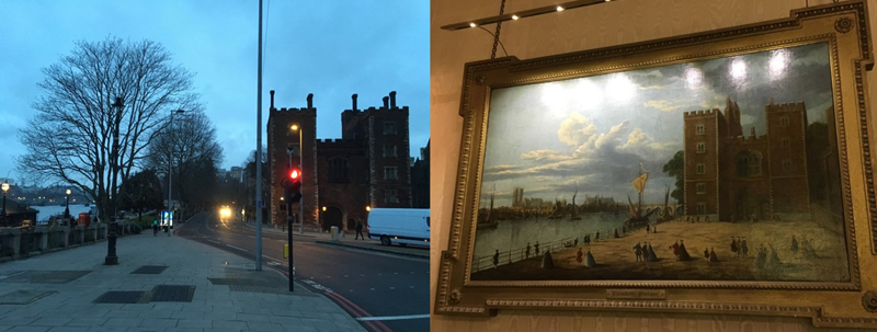
In estuaries the influence of non-astronomical factors, such as changes in water channel depth and width, can be particularly large. For example, the tidal range in London increased from 2 meters during Roman times to 7 to 8 meters over the past 200 years as a result of engineering works both in the channel of the River Thames and along its banks.
At the peak of the last ice age, about 20,000 years ago, the tides were up to twice the present-day size in the Atlantic due to sea level being 130 meters lower than it is today. That changed how the tides move around the basins, allowing them to get very large. On longer timescales, we think the tides are now the most energetic they have been for several hundreds of millions of years.
What might be the causes of these changes?
The tides move like a very long wave so speed is determined by water depth. This means that the tide can be amplified by resonance if a set fraction of the wavelength perfectly matches the size of the basin in which the wave is moving. The wave can then grow very large even though the forcing – the tide outside the basin – is small. This is the same mechanism allowing a child on a swing to swing high even with small pushes – by forcing the swing at the right time you make the system resonant. This is what is happening in the areas mentioned above.
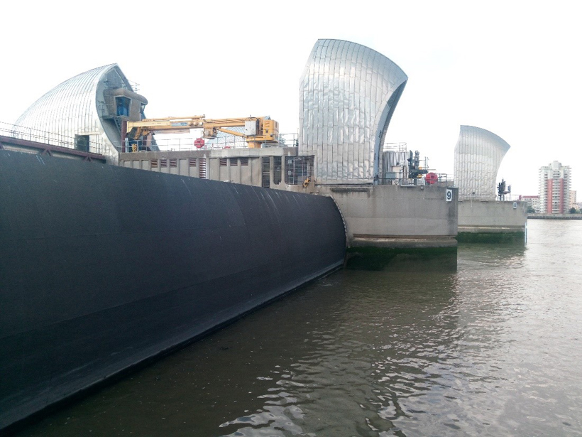
Human activities that can substantially modify the tide include beam trawling, constraining estuaries, deepening channels, land reclamation, and controlled flood plains.
On regional and local scales, several other non-astronomical factors can change the tide. For example, the character of the seabed can be changed by natural and anthropogenic processes such as beam trawling, a method of fishing where the net is dragged along the seafloor. This leads to a flattening of the seabed, in turn reducing bottom friction and potentially causing localized changes of the tide. Other examples of human activities that can substantially modify the tide include constraining estuaries with sea walls, deepening channels by dredging, land reclamation, and controlled flood plains.
How may the tides continue to change over the coming decades and centuries, and what might be the consequences?
In a global context, the tides will weaken with future sea level rise. The regional picture, however, is more complex with some coastlines likely to experience a decreased tidal range while others see an increase. The European continental shelf will likely have a mixed response with increases in some parts and decreases in others, depending on where flood defenses are built.
These changes, although relatively small, can have serious impact on coastal communities. Future increases in tidal range are not always considered when flood defenses or coastal structures are designed. Although they are planned to have a life span of several decades, they may not be able to handle both sea level rise and an enhanced tide. Changed tides may also need to be considered in the design of waterways where tolerances for shipping are small.
What are some of the unresolved questions where additional research, data or modeling is needed?
We need better detailed estimates of how the tides will change under different sea level scenarios initiated by the ongoing melting of the Antarctic and Greenland ice sheets.
We need better detailed estimates of how the tides will change under different sea level scenarios initiated by the ongoing melting of the Antarctic and Greenland ice sheets. This will require more measurements of ocean depth; many shallow seas are mapped at very high resolution, but there are mostly scattered observations along shipping routes in the deep ocean. Projects such as the Nippon Foundation-GEBCO Seabed 2030 Project are looking to address this. Improved scenarios of the future coastal geometries, largely influenced by human policy decisions, are also necessary.
—J. A. Mattias Green ([email protected]; ![]() 0000-0001-5090-1040), School of Ocean Sciences, Bangor University, UK; Ivan D. Haigh (
0000-0001-5090-1040), School of Ocean Sciences, Bangor University, UK; Ivan D. Haigh (![]() 0000-0002-9722-3061) and Mark D. Pickering (
0000-0002-9722-3061) and Mark D. Pickering (![]() 0000-0002-2219-6054), National Oceanography Centre, University of Southampton, UK
0000-0002-2219-6054), National Oceanography Centre, University of Southampton, UK
Citation:
Green, J. A. M.,Haigh, I. D., and Pickering, M. D. (2020), The ups and downs of tides, Eos, 101, https://doi.org/10.1029/2020EO148034. Published on 13 August 2020.
Text © 2020. The authors. CC BY-NC-ND 3.0
Except where otherwise noted, images are subject to copyright. Any reuse without express permission from the copyright owner is prohibited.