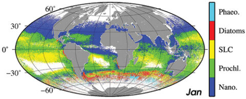
Satellite ocean color radiometry (OCR) is a powerful tool providing recurrent measurements of global phytoplankton biomass on synoptic scales. OCR is increasingly used in applications related to societal benefits (e.g., harmful algal blooms) and is a key tool for research into the global carbon cycle and other biogeochemical cycles.
To improve collaboration and advance OCR research, ocean color research scientists and representatives from various space agencies met in San Francisco, Calif., in June 2015 for the second International Ocean Colour Science (IOCS) meeting. The goal of the meeting, hosted by the International Ocean Colour Coordinating Group, was to inform participants about cutting-edge research as well as agency mission plans and to collectively agree on requirements for sustained OC research and operations.
Considerable value can be added to OC data by making use of complementary data streams and integrating color data with biophysical models at a wide range of scales. Keynote speaker Marina Lévy (Université Pierre et Marie Curie, Paris) noted that OC imagery reveals beautiful submesoscale (1–10 km) features in the distribution of phytoplankton, which are poorly represented in models and data analysis. High-resolution biophysical models can be used to address the drivers of this variability.
Another issue discussed was the need for higher time and space resolution in both satellite products and models. Geostationary OC missions (GEO), which are pointed permanently at an ocean region, have the potential to fill this gap. GEO missions such as South Korea’s Geostationary Ocean Color Imager (GOCI), the future European Geostationary Ocean Color Advanced Permanent Imager (GEO-OCAPI) and NASA’s Geostationary Coastal and Air Pollution Events (GEOCAPE) can provide improved cloud-free coverage and a revisit frequency (less than hourly) adapted to sample rapidly changing environments such as coastal areas.
High spatial resolution satellite data open up new applications for coastal and inland waters, despite being designed for land applications.
Participants learned that high spatial resolution satellite data, e.g., Landsat 8 (30 meters; U.S. Geological Survey) and the new Sentinel 2 (10–60 meters; European Space Agency), open up new applications for coastal and inland waters (e.g., sediment transport, benthic composition, and water quality monitoring) despite being designed for land applications. Landsat 8 has demonstrated validated products for chlorophyll a concentration, suspended particulate matter, colored dissolved organic matter, and cyanobacteria.
In another breakout session, participants reviewed the progress and challenges of hyperspectral remote sensing and explored work toward future missions, such as NASA’s Pre-aerosol, Clouds, and ocean Ecosystem (PACE) and Hyperspectral Infrared Imager (HyspIRI) missions and Germany’s Environmental Mapping and Analysis Program. The increased number of spectral bands will potentially provide considerable information on phytoplankton community characteristics and allow targeting of new phenomena and techniques (e.g., phycobiliprotein absorption and new atmospheric correction techniques) with a broad range of applications, from water quality to understanding ecosystem variability.

One requirement for producing climate-quality OC time series is to “vicariously calibrate” the satellite sensor using International System of Units (SI) traceable measurements of in situ water-leaving radiance at carefully selected ocean sites. Keynote speaker Kenneth Voss (University of Miami) presented the history of the Marine Optical Buoy (MOBY), as well as plans to implement new sensor and deployment technology. MOBY, which has continuously monitored radiances in Hawaiian coastal waters for the past ~20 years, and the Buoy for the Acquisition of Long-Term Optical Time Series (BOUSSOLE), located in the Mediterranean Sea, are the two vicarious calibration sites presently providing in-water data for all OC satellites. Reported differences between satellite- and MOBY-measured radiances are on the order of 1%–2% for major OC sensors.
Meetings such as IOCS 2015 provide a critical forum for discussion between space agency representatives and research scientists that can ultimately lead to better science. Meeting participants made several recommendations for future action, including funding dedicated field campaigns open to all scientists, developing a framework for uncertainty statistics associated with ocean color measurements, and standardizing data quality metrics and their derivation across multiple missions. The next IOCS meeting will take place in Lisbon, Portugal, from 15 to 19 May 2017.
A complete meeting report plus all presentations and poster abstracts is available at https://iocs.ioccg.org/. IOCS 2015 was sponsored by NASA, the National Oceanic and Atmospheric Administration, the European Space Agency, the European Organisation for the Exploitation of Meteorological Satellites, the Centre National d’Etudes Spatiales, the Scientific Committee on Oceanic Research, and the Gordon & Betty Moore Foundation.
—Venetia Stuart, International Ocean Colour Coordinating Group (IOCCG), Bedford Institute of Oceanography, Dartmouth, NS, Canada; email: [email protected]; Stewart Bernard, IOCCG Chair, Council for Scientific and Industrial Research, Cape Town, South Africa; and Heidi Dierssen, University of Connecticut at Avery Point, Groton
Citation: Stuart, V., S. Bernard, and H. Dierssen (2016), New technology and teamwork to tackle ocean color radiometry, Eos, 97, doi:10.1029/2016EO043119. Published on 11 January 2016.
Text © 2016. The authors. CC BY-NC 3.0
Except where otherwise noted, images are subject to copyright. Any reuse without express permission from the copyright owner is prohibited.

