Satellite remote sensing offers a unique global observational platform for pursuing societal benefits in ways that are not feasible using only conventional ground-based approaches. Reaping these benefits requires an intimate engagement between the scientific community and a wide range of stakeholders. This issue has taken on a new urgency, as the strong interplay between human activity and nature drives change on almost all continents, with rules set by human activities as well as nature.
The pursuit of a more sustainable, safer, and happier future drives the study of planet Earth, with its changing environmental conditions and natural resources. Observations from visible, laser, infrared, and microwave satellite sensors already provide information for managing land, water, agriculture, energy, disaster response, and ecosystem functions [Wood et al., 2011]. During the last few decades, we have been quite successful in taking advantage of the science and observations afforded by satellites to make spectacular societal impacts.
For example, the 1976 Big Thompson Flood in Colorado killed 144 people, whereas the 2013 Boulder/Lyons Flood, also in Colorado, was managed with eight casualties [Hamill, 2014]. Similarly, a cyclone off the coast of Bay of Bengal (Bangladesh) in 1991 took more than 65,000 lives and left 10 million homeless. The 2009 cyclone Aila in the same region killed a few hundred people and rendered 1 million homeless [Chowdhury et al., 1993; Paul, 2009]. A significantly improved warning system facilitated by Earth-observing satellites arguably contributed to the savings in life and property in both instances.
We are gradually developing a plethora of more mature remote sensing technology missions for routine environmental monitoring. These include Landsat and altimetry missions, hydrologic missions like Global Precipitation Measurement, NASA’s Gravity Recovery and Climate Experiment mission, and NASA’s anticipated Surface Water and Ocean Topography mission. However, we lack much of the capacity required to handle the petabyte-scale influx of satellite environmental data that will become available.
An Underused Resource
To take advantage of satellite observational capability to enhance and accelerate societal applications around the world, scientists and other stakeholders must collaborate to find answers in the coming decade. Time is of the essence, as long gestation periods, sometimes decades, are often necessary to transition from scientific research to real-world benefits for stakeholders.
We are not yet taking complete advantage of the abundant scientific output and remote sensing data emerging rapidly from satellite missions, and we are failing to convert them to actionable products that improve decision making for users [Hossain, 2015].
This competition ignores the synergistic power and benefits that combining data from the many Earth-observing satellites could provide.
Thus far, the benefits have mostly accrued in the developed nations of Europe and North America. Global satellite observational coverage would be especially useful in the developing world because ground‐based measurements are often largely absent here. However, programs to apply satellite observations to challenges in the developing world often struggle for longevity and continuity.
Also, the combined observational power of the multiple Earth-observing satellites too often places emphasis on the benefits from individual missions and observing systems. This observational power is currently not being harnessed to produce more durable societal benefits. The struggle for support and survival has often pitted various missions against each other. This competition ignores the synergistic power and benefits that combining data from the many Earth-observing satellites could provide, missing an opportunity to provide even more spectacular societal benefits.
A Fly’s-Eye View
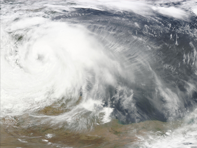
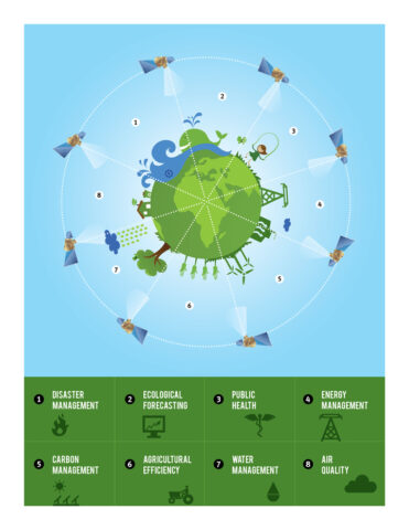
The scope of the opportunity and abundance of satellite observations confronting us in the not-too-distant future is already apparent. Figure 1 illustrates the basic concept behind using NASA’s constellation of satellites for societal application. This concept is similar to the “A-Train” (Figure 2), a series of coordinated satellites that passes over the same region in quick succession to monitor various aspects of Earth’s atmosphere. The best use of such a system for applications requires a holistic use of the combined observational power of all of these satellites.
Our current and future satellite constellation for societal applications essentially provides us with a “compound eye” view of the world. Like the composite eye of a fly, coordinated satellites look with many eyes at the same time to see the world from many different angles, using an array of instruments (Figure 1).

To take advantage of this composite view is to make better decisions, using an application that is wired to expect and accept all the different observations across multiple platforms simultaneously. Such a capability could be used to address upcoming issues in water management [Maswood and Hossain, 2015, for example] or agricultural management.
The Way Ahead
Expanding the numbers and uses of satellite remote sensing instruments alone will not be sufficient to address society’s needs. Availability of a satellite mission data portal does not necessarily imply universal access or easy applications [Hossain, 2012]. Uncertainty in measurements, scale, end user perception, operating constraints, data latency, mission interaction, scalability, and intuitiveness of the application tool must also factor into the equation.
In anticipation of the coming era of plentiful Earth observations from satellites, the Earth science community must now put some thought into identifying key applications and key scientific issues. Now is the time for making connections between the regional stakeholder communities from around the world and the community that provides the science that fuels an application.
The satellite and science communities must now engage with the stakeholder community to discuss what is possible and what is most urgent.
These connections will allow a meaningful discussion that has been largely uncoordinated but is necessary to globalize and accelerate societal applications of satellite data. The satellite and science communities must now engage with the stakeholder community to discuss what is possible and what is most urgent. These communities must set priorities to determine what must be left behind in order to scale up what is possible for the best societal applications.
Five upcoming challenges urgently need discussion, debate, and resolution as a long-term agenda:
- What types of value-added products and information should we provide for resource-constrained public and national stakeholder communities and agencies?
- What types of industry or private sector partnerships will most benefit the scientific research needed to meet societal needs?
- How can we leverage the combined observational power of our many Earth-observing satellite missions (current and future) in a synergistic manner to rapidly multiply societal applications?
- How can we use the scientific innovation from satellite remote sensing data to trigger durable and robust applications that do not require long-term incubation or external support?
- From an economic standpoint, what is the optimal business model to support a sustainable partnership between scientific communities and the stakeholders?
One way to answer these questions is to take a regional and thematic approach, in order to map an agenda forward for Earth science applications of satellite remote sensing. For example, a community effort in 2013 focused on conservation biology and developed highly useful recommendations that could serve as inspiration for other areas and communities [Rose et al., 2014]. This effort brought together a group of remote sensing scientists and members of conservation organizations. They identified 10 conservation questions where the use and analysis of remote sensing data would greatly increase the potential for finding an answer.
Although societal benefits from space observations share common features, what works for region X may not necessarily apply to region Y, even when the problems are similar—thus, the need for regional solutions.
We need not confine ourselves to Earth observations from satellites. Airborne and ground-based measurement activities frequently aid in making decisions and improving applications. Also, microsatellites and unmanned aerial vehicles are becoming more widespread. Currently, the scientific community is divided about how these activities should be pursued in the coming years for the greater benefit of stakeholders.
Because it will take time and effort to reach consensus on these numerous issues, now is the time to get busy and build a well-mixed environment of scientific and application stakeholder communities.
References
Chowdhury, A. M. R., A. U. Bhuyia, A. Y. Choudhury, and R. Sen (1993), The Bangladesh cyclone of 1991: Why so many people died, Disasters, 17, 291–304.
Hamill, T. M. (2014), Performance of operational model precipitation forecast guidance during the 2013 Colorado front-range floods, Mon. Weather Rev., 142, 2609–2618.
Hossain, F. (2012), Do satellite data portals today reach out to diverse end users around the world? Bull. Am. Meteorol. Soc., 93, 1633–1634.
Hossain, F. (2015), Science, science everywhere, nor any drop to drink: Three solutions for an outdated system [online], IEEE Earthzine, 10 Feb. [Available at https://earthzine.org/2015/02/10/science-science-everywhere-nor-any-drop-to-drink-three-solutions-for-an-outdated-system/.]
Maswood, M., and F. Hossain (2015), Advancing river modeling in ungauged river basins using remote sensing: The case of Ganges-Brahmaputra-Meghna basins, J. River Basin Manage., in press.doi:10.1080/15715124.2015.1089250
Paul, B. K. (2009), Why relatively fewer people died? The case of Bangladesh’s Cyclone Sidr, Nat. Hazards, 50, 289–304.
Rose, R. A., et al. (2014), Ten ways remote sensing can contribute to conservation, Conserv. Biol., 29, 350–359.
Wood, E. F., et al. (2011), Hyperresolution global land surface modeling: Meeting a grand challenge for monitoring Earth’s terrestrial water, Water Resour. Res., 47, W05301, doi:10.1029/2010WR010090.
—Faisal Hossain, Department of Civil and Environmental Engineering, University of Washington, Seattle, Wash.; email: [email protected]
Citation: Hossain, F. (2015), Data for all: Using satellite observations for social good, Eos, 96, doi:10.1029/2015EO037319. Published on 14 October 2015.
Text © 2015. The authors. CC BY-NC 3.0
Except where otherwise noted, images are subject to copyright. Any reuse without express permission from the copyright owner is prohibited.