Seventy percent of Earth’s surface geology is under water, but let’s face it: There are few options for exploring beneath the seafloor, and the limited number of techniques for subseafloor exploration presents a challenge. But with modern seismic imaging techniques it’s surmountable, and the opportunities are extremely exciting.
We are at a juncture where an increment of additional support for seismic facilities will have a leveraging effect with tremendous science impact for a broad community.
The real challenge at present is finding financial support. We need a new funding commitment in the United States to address recent declines in National Science Foundation (NSF) seismic facilities support. We are at a juncture where an increment of additional support from U.S. funding agencies, academic institutions, and/or private contributions for seismic facilities will have a leveraging effect with tremendous science impact for a broad community. With less support, we will still progress, but with substantial new challenges and uncertainty throughout marine science.
During marine seismic surveys, ships use pneumatic sound sources to generate acoustic waves beneath the water’s surface. Long floating arrays of hydrophones pick up the sound waves, reflected back by subsurface sedimentary layers and crustal structures, to provide a detailed picture of the geology below the ocean floor.
This technique provides invaluable information for the scientific and petroleum exploration communities alike. However, research funding reductions continue to hamper the marine geoscience community’s ability to collect seismic data in areas of scientific interest.
Although relatively few scientists are directly involved in collecting these data, a much larger community relies on the data they produce. Thus, a dwindling data stream produces ripple effects that extend far beyond the scientists and crews who go to sea.
The science community needs to understand what those ripple effects mean. Below, we’ve outlined a few options that we see as the most likely going forward.
Seismic Techniques Provide Context
Data from beneath the ocean floor come from several sources, and each type has its own strengths and limitations.
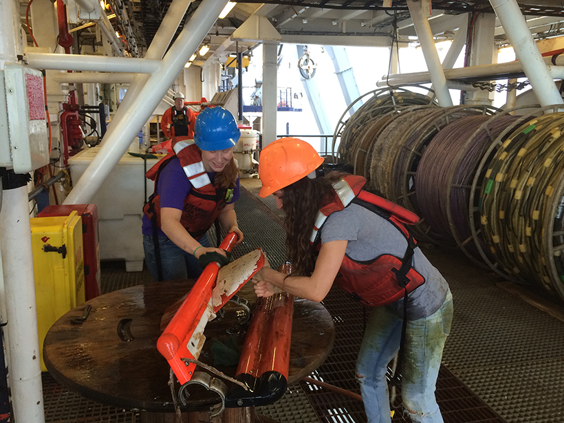
Drilling and piston coring provide valuable samples for establishing lithologies, ages, geochemistry, and physical properties, but they provide a keyhole view beneath the ocean floor. Cores are only a few centimeters wide, and the information we gain is generally limited by both depth of penetration and the cost of coring expeditions.
Electromagnetic methods are designed for a broader view, but they provide only bulk property constraints, averaged over the sampling area.
The reality is that only marine seismic data have the resolution to see into the subsurface, to reveal regional geologic structure, and to help us understand the broader context of “ground truth” sampling from cores.

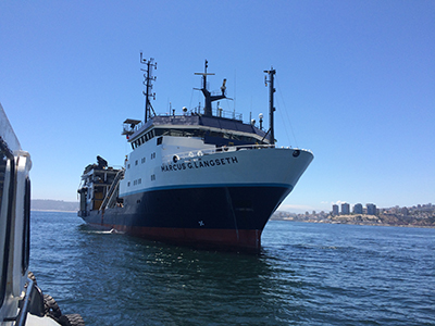
We have some amazing seismic data analysis techniques available to us: 3-D imaging, full-waveform inversion, and vertical profiling. We also have technologies to gather these data: Large spatial deployments of ocean bottom seismometers (OBSs), for example, are now possible with governmentally supported OBS instrument pools in the United States and other countries. Advanced multichannel seismic (MCS) reflection platforms, like the United States’ R/V Marcus G. Langseth, are equipped with multiple hydrophone arrays and streamers, which can be as long as 15 kilometers. And we have improved computational facilities for data analyses.
Together, these capabilities allow us to “see” into the subseafloor to address fundamental geologic questions on ocean crust formation and evolution, subduction zone earthquake genesis, fluid migration within the crust, continental rifting, and the list goes on.
More Technology but Fewer Cruises
However, the availability of high-quality seismic images is in decline. The International Ocean Discovery Program (IODP) Science Evaluation Panel (SEP), scientific ocean drilling’s primary review body, sent the following statement for programmatic review in 2015:
The SEP wishes to convey concern regarding the increased pressures on the acquisition of academic active-source seismic data, some of which by design is conducted in support of scientific ocean drilling. Continued reduction in the international marine geoscience communities’ ability to collect seismic data in areas of scientific interest is jeopardizing the scope and impact of IODP science. The SEP consensus is that the IODP should stress the importance, both to member country funding agencies and environmental permit organizations worldwide, of high-quality subsurface images for science and safety in connection with expected continuation of IODP.
The SEP concern is justified. From 1995 to 2005, the R/V Maurice Ewing, then the primary U.S. seismic acquisition facility, conducted on average 4.7 seismic (MCS and OBS) cruises each year (in addition to higher-resolution surveys) and participated in multiship vertical seismic profiling projects. In contrast, during the past decade, the R/V Marcus G. Langseth, the Maurice Ewing’s successor ship, has conducted an average of 3.2 cruises each year, with only 5 total in 2016 and 2017.
This decline raised questions explicitly addressed in the 2015 National Academy of Sciences’ decadal survey of ocean sciences: Should the National Science Foundation consider divestiture of this expensive facility to maintain a healthy balance between spending on technology and infrastructure and spending on science? Are seismic facilities serving too few scientists to justify such infrastructure?
Worth the Investment?
To address these questions, the University–National Oceanographic Laboratory System (UNOLS) conducted a June 2016 survey to assess the community’s seismic needs. Response was excellent; in 2.5 weeks, 263 completed the survey. (As a comparison, the virtual town hall that surveyed the ocean sciences community as input to the National Academy of Sciences report generated about 400 responses over 20 weeks.)
The UNOLS survey confirmed that although a minority of the respondents acquire data at sea, and most of those are senior scientists (at least 20 years post Ph.D.), the seismic data they collect are used by many more. Half of the respondents considered themselves nonspecialists who rely only on processed seismic data and interpretations, without other involvement.
The UNOLS survey confirms the demand for seismic data beyond the small number of primary investigators who acquire and process them.
The majority of respondents had never submitted an NSF proposal to acquire seismic data; 75% had not served as a primary investigator (PI) or co-PI on a seismic acquisition and processing project in the previous 5 years. Many stated that they do not have the background to acquire seismic data. However, 94% said they plan to use seismic data in the future, primarily through collaborations.
The most commonly cited reason for not serving as a PI on a Langseth-type acquisition cruise was a lack of background in seismology or know-how with acquisition, processing, and interpretation techniques. Processing seismic reflection data requires extensive technical knowledge, advanced computer systems equipped with appropriate (often expensive) software, and generally 1–2 years or more of postacquisition processing effort.
Overcoming these challenges is not practical or even possible for many; the pool of seismic specialists will remain small. Yet the UNOLS survey confirms the demand for seismic data beyond the small number of PIs who acquire and process them. Therefore, a loss of acquisition facilities would have wide-reaching effects on Earth sciences.
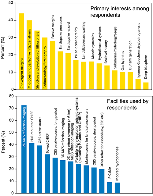
The survey also confirms that many seismic tools (Figure 1) are needed to address the diverse science goals of current and envisioned U.S. Earth science programs, some of which include international partners and span shore lines (e.g., IODP, Geodynamic Processes at Rifting and Subducting Margins (GeoPRISMS), and subduction zone observatory).
Weighing the Options
Can we maintain seismic acquisition capabilities with reduced funding? With the exception of the Scripps Institution of Oceanography high-resolution (short-streamer) portable MCS system, Langseth is the only U.S. seismic facility. Langseth can acquire 3-D volumes and 2-D data with streamers more than 6,000 meters long, an “aperture” long enough to image at crustal scales.
In August 2016, the NSF Division of Ocean Sciences distributed a “Dear Colleague” letter stating that “OCE anticipates spending an annual average of ~$8M for ship support and ~$2M for technical support, funding permitting, and supporting seismic infrastructure.” At current Langseth rates, this amounts to operations for some 90 to 112 days, only about 75% of the total 120–150 days per year considered viable for any UNOLS vessel.
Operating fewer than 120–150 days in a given year actually increases the cost per day. This makes the Langseth operational costs stand out even more while limiting support for the highly experienced crew necessary for state-of-the-art seismic operations.
Aside from making Langseth a general-purpose vessel and using it to serve other marine science programs, options are limited:
Option 1. One option is to improve efficiency and increase funding. Since 2015, Langseth has operated according to a long-range framework to minimize transits and maximize opportunities through developing regional and international collaborations. In late 2017 and 2018, Langseth will operate offshore New Zealand, with support from that country, Japan, and the United Kingdom. Unfortunately, international support is limited because partner countries must also support their own facilities.
Improved efficiency is also possible through sharing facilities internationally. Langseth is currently the most capable academic facility for crustal-scale 2-D/3-D imaging, but it is the only U.S. option for crustal-scale work. International collaboration to exchange Langseth with other international vessels would improve both opportunity and efficiency globally; the Ocean Facilities Exchange Group does this within the European Union.
A scaled back seismic program will not only affect the PIs who responded to the UNOLS survey, but it will also affect U.S. institutions they represent through loss of NSF support: those who receive funding for seismic data acquisition and those relying on seismic results. Among international programs affected by scaled-back seismic facilities, IODP stands out. Broad support for seismic facilities from U.S. academic institutions would produce returns for these institutions.
Recent progress on understanding the largest earthquakes and tsunamis on Earth will be severely compromised without an ability to see deep subduction zone structures and measure physical properties with seismic tools.
Institutional support could provide Langseth operational costs, but only through collaborative, multiyear commitments. As NSF described in their recent program solicitation “Provision of Marine Seismic Capabilities to the U. S. Research Community,” the agency is committed to providing Langseth or equivalent capabilities, but the proposed funding levels ($10 million per year) would be problematic for the current model. Is any other model viable?
Option 2. Without Langseth, there will still be exciting science to do, using data from shorter streamers, archived data, and data available (occasionally and in certain areas) from industry.
Unfortunately, this approach will change the foci of U.S. seismic studies. For example, reduced seismic imaging capability would limit large, successful international programs like IODP. Recent progress on understanding the largest earthquakes and tsunamis on Earth generated at subduction zones will be severely compromised in the future without an ability to see deep subduction zone structures and measure physical properties with seismic tools. Science would need to target shallower settings: submarine landslides, gas hydrates, fluid and gas migration, sea level change, and the like, using cheaper, portable (higher-resolution, smaller) seismic systems.
Data would be less complicated and easier to process. Higher resolution could even be 3-D, using P-cable systems available from multiple U.S. institutions. However, these systems can rarely deploy streamers long enough or sources powerful enough to fully characterize even shallow stratigraphy and structure, and they can’t address crustal-scale problems at all.
Going Commercial?
In 2015, NSF conducted a workshop with invited members from the marine seismic community, primarily the now disbanded Marcus Langseth Scientific Oversight Committee, to consider a long-streamer portable system and commercial contracting. The workshop report concluded that the weight and size of portable systems incorporating long (6–8 kilometer) streamers with moderate-size, tuned acoustic sources made them impractical for current UNOLS vessels.
Commercial contracting is viable for long-offset 2-D and 3-D acquisition; however, availability could be limited by high costs (especially mobilization costs for work far from oil and gas provinces, where commercial efforts tend to focus), cost volatility, and changes in ship availability due to hydrocarbon market cycles. These cruises would also lack simultaneous multibeam or gravity and magnetics data acquisition, which has historically been available on U.S. seismic vessels, and student training opportunities would be uncertain and problematic.
Commercial contracting has been used successfully occasionally in the past, but it is risky to rely on contracting to maintain a regular, global crustal-scale acquisition program as we do now.
Ironically, this development comes at a time when the IODP is increasing its number of operational days. Other exciting developments, such as seafloor geodesy, will also need an understanding of subsurface structure for tectonic context.
There is considerable imaging science to be done, with or without Langseth. However, the broad impact of scaling back marine seismic facilities on Earth science makes it time to find more financial support for marine seismic acquisition.
—Nathan Bangs (email: [email protected]) and James A. Austin Jr., Institute for Geophysics, University of Texas at Austin
Citation:
Bangs, N.,Austin, J. A., Jr. (2017), Keeping our focus on the subseafloor, Eos, 98, https://doi.org/10.1029/2017EO083309. Published on 03 October 2017.
Text © 2017. The authors. CC BY-NC-ND 3.0
Except where otherwise noted, images are subject to copyright. Any reuse without express permission from the copyright owner is prohibited.