
Subduction zones contain many of Earth’s most remarkable geologic structures, from the deepest oceanic trenches to glacier-covered mountains and steaming volcanoes. These environments formed through spectacular events: Nature’s largest earthquakes, tsunamis, and volcanic eruptions are born here.
Great subduction zone earthquakes can cause coastal subsidence in minutes that has impacts comparable to a century or more of climatically driven sea level rise. They can radiate shaking waves that trigger widespread landslides and submarine slope failures and can spawn tsunami waves that reach distant lands. Eruptions can produce fast-moving mudflows as well as high-lofted ash clouds complete with their own lightning systems.
The geologic processes in subduction zones shape surface morphology, couple plate motions to mantle convection, control resource distributions, and even interact with Earth’s climate—volcanic gases can cool the climate, and sediments at subduction margins are important reservoirs for greenhouse gases. In short, the diverse environments in subduction zones are natural laboratories for investigating a wide range of interlinked processes.
Should such an observatory focus on one subduction zone or multiple zones?
The myriad opportunities for collaborative work among scientific disciplines, institutions, and nations have inspired a grassroots movement to create a subduction zone observatory (SZO), now in a nascent stage of planning. Over the past few years, Earth scientists have been discussing options for its geographic scope and structure. For example, should such an observatory focus on one subduction zone or multiple zones? Should it be managed as a center or an umbrella organization? How should resources be balanced between new facilities and funds needed for research?
As part of these discussions, we held a series of seminars focused on SZO topics. A more official and much broader workshop will occur in September 2016. Here we share ideas that have emerged from past talks in an effort to grow the movement, advance community discussion, and help shape a vision.
Why Invest in an SZO Now? Lessons from Tohoku
Scientific focus on subduction zones has increased dramatically in the past decade, accompanying a recognition that large numbers of people are migrating to urban areas that lie within subduction zones. Scientists recognize the hazards inherent in living near tectonically active margins [Bilham, 2009] and are motivated to understand them so that they may provide the best advice to protect communities.
![Fig. 1. Fault slip from the Mw9 Tohoku, Japan, earthquake in 2011. Seismic and GPS waveform modeling revealed significant slip in patches with varying characteristics (amplitudes color coded), as if it were a composite of smaller earthquakes. The plate interface (fault) dips to the west. A downdip patch radiated the high-frequency waves that damaged buildings (right map), and the largest slip on an updip patch (left map) generated the enormous tsunami. Modified from Frankel [2013].](https://eos.org/wp-content/uploads/2016/05/fault-slip-2011-mw9-earthquake-tohoku-japan.png)
Investments in onshore and offshore instrument arrays have enhanced the resolution of our understanding of subduction-related processes. Multifaceted analyses can make monitoring systems and hazard assessments more robust. For example, the Mw9.0 Tohoku earthquake, which shook Japan in 2011, occurred in an area with an abundance of onshore and offshore observations, including geodetic and seismic signals, marine seismic reflection profiles, bathymetry, tsunami wave heights, and novel seafloor acoustic GPS and pressure measurements. Offshore observations provided, for the first time, unambiguous evidence for why the tsunami was so large—they documented several tens of meters of fault slip near the Japan Trench (Figure 1). Rich data sets and multifaceted analyses also revealed that days before the Tohoku earthquake, the plate interface began slipping slowly, with slip propagating toward the initiation point of the Mw9.0 earthquake [Kato et al., 2012].
The 2011 Tohoku earthquake illustrated the potential of an SZO to significantly advance understanding of the processes at work before, during, and after a major event. It also prompted sobering retrospectives on the difficulty of anticipating its enormous size, even after meticulous paleoseismological studies [Sawai et al., 2012], underscoring the need for further research investments that will make subduction zone populations more resilient.
Key SZO Features
Ideally, an SZO would produce research that is transformational, multidisciplinary, amphibious, and international. As illustrated by the Tohoku earthquake and tsunami, an SZO would enable transformational research by facilitating acquisition and analysis of disparate data with multiple synergistic applications considered from the start. An SZO must be multidisciplinary to understand linkages between processes within subduction zones and the transitions to adjacent tectonic environments.
The tremendous diversity of processes and physical characteristics displayed by the world’s subduction zones begs for a global scope. Although the geographic scope of an SZO remains to be determined, we illustrate key features of an SZO with some examples of broad questions addressed in particular regional studies. Two of the three examples come from the Cascadia subduction zone (Figure 2a), only because it is where most of the authors reside and work.
How do accretionary prism sedimentation, geochemistry, ocean currents, and climate change interact with gas hydrate stability? Subduction margin sediments contain a significant fraction of Earth’s greenhouse gas methane. This methane, derived from sediments of terrestrial origins and organisms at the sea surface, gets bound within the solid crystalline water lattices of gas hydrates. In Cascadia, multichannel seismic reflection profiles reveal a gas hydrate reservoir in a swath along the seafloor where the water depth exceeds 500 meters (depth contour in Figure 2a), above which hydrates decompose. However, seawater warming at these depths threatens to decompose some of this hydrate. This could increase bottom water acidity and lower the water’s oxygen content, which could have dramatic negative effects on organisms and accelerate climate change.
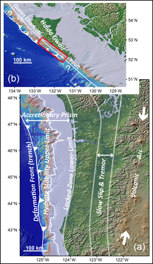
How do subduction zones transition to other types of tectonic regimes? At the northern end of the Cascadia subduction zone (Figure 2b), the plate motions change from converging toward one other with associated subduction and thrust faulting along shallowly dipping planes to moving parallel to each other, accommodated by steeply dipping strike-slip faulting, in which most of the movement is horizontal. The Queen Charlotte Fault system is this latter “transform” boundary. The 2012 M7.8 Haida Gwaii earthquake in British Columbia occurred on this system and illustrated the complexity of this transition, with surprisingly many of the characteristics of a subduction zone thrust event.
Recent studies of the Alaska subduction zone demonstrate that during great subduction zone earthquakes, as ruptures approach the seafloor, they sometimes propagate from the plate interface to secondary faults, sometimes also deforming ductile overlying sediments. Uncertainties in seafloor fault displacements remain the most significant unknown in local tsunami hazard assessments [Geist, 2002]. These hazards could be reduced with an SZO monitoring system and seafloor mapping before and after events.
How do subducting slabs and volcanism affect continental crust creation? Processes that generate magmas in subduction zones are the “factories” that create continents, based on the similarity between the compositions of continental crust and volcanic arcs. Numerous hypotheses exist about the processes by which slab materials accrete, subduct, melt, mix, and emerge at crustal depths or extrude from active volcanoes. Testing these hypotheses requires integrated studies spanning the disciplines of chemistry, petrology, fluid dynamics, geology, and seismology, with four-dimensional imaging.
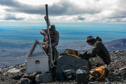
An SZO must be amphibious, and this requires new means of collecting and integrating offshore and onshore observations. Scientists need sustained marine geodetic observations to characterize subduction zone deformation processes over many time scales, from plate motions (decades) to earthquake fault slip (seconds). A geodetic component of an SZO could include high-resolution repeat seafloor mapping, pressure gauges, and novel tools like fiber-optic strain meters. These and other frontier offshore measurements are applicable to multiple scientific questions and practical applications.
A High-Impact, Societally Relevant SZO
The envisioned SZO would contribute to the scientific understanding needed to build societal resilience in the face of natural hazards. It would also serve as an international educational resource. For example, recording earthquake ground motions using densely spaced networks would enable us to properly calibrate the simulations that underlie seismic hazard assessments and building codes (Figure 1).
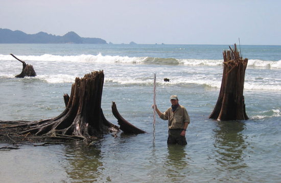
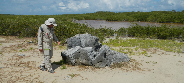
An SZO should be built collaboratively with those responsible for hazard mitigation and response. Perhaps most important, it could offer opportunities to involve citizens in research, through educating the public and making them stakeholders. For example, local scientists, students, and interested citizenry could be engaged to make biological and survey observations before and after events and to document coastal uplift and subsidence, tsunami inundation, or storm surge impacts (Figure 3). Such engagement could extend understanding of the effects of major natural events in places where we lack prior baselines, and it would fit naturally into educational programs that teach by doing.
A Path Toward an SZO
We must lead, advocate for, and contribute to proposals to governmental and private sector institutions to support, design, and build a subduction zone observatory.
Moving an SZO from concept to reality will require coordination within and among academic and hazards assessment communities. Individually and as members of professional entities, we must lead, advocate for, and contribute to proposals to governmental and private sector institutions to support, design, and build an SZO. If the Earth science community collaboratively pursues creative strategies, developing an SZO may simultaneously serve to enrich observational tools, improve hazard models, and enhance our basic understanding of one of Earth’s most dynamic environments.
References
Bilham, R. (2009), The seismic future of cities, Bull. Earthquake Eng., 7, 839–887, doi:10.1007/s10518-009-9147-0.
Frankel, A. (2013), Rupture history of the 2011 M9 Tohoku Japan earthquake determined from strong-motion and high-rate GPS recordings: Subevents radiating energy in different frequency bands, Bull. Seismol. Soc. Am., 103, 1290–1306.
Geist, E. L. (2002), Complex earthquake rupture and local tsunamis, J. Geophys. Res., 107(B5), 2086, doi:10.1029/2000JB000139.
Kato, A., K. Obara, T. Igarishi, H. Tsuruoka, S. Nakagawa, and N. Hirata (2012), Propagation of slow slip leading up to the 2011 Mw 9.0 Tohoku-Oki earthquake, Science, 335, 705–708.
Sawai, Y., Y. Namegaya, Y. Okamura, K. Satake, and M. Shishikura (2012), Challenges of anticipating the 2011 Tohoku earthquake and tsunami using coastal geology, Geophys. Res. Lett., 39, L21309, doi:10.1029/2012GL053692.
—Joan Gomberg, U.S. Geological Survey, Seattle, Wash.; and Department of Earth and Space Sciences, University of Washington, Seattle; email: [email protected]; Paul Bodin and Jody Bourgeois, Department of Earth and Space Sciences, University of Washington, Seattle; Susan Cashman, Department of Geology, Humboldt State University, Arcata, Calif.; Darrel Cowan, Ken Creager, Brendan Crowell, and Alison Duvall, Department of Earth and Space Sciences, University of Washington, Seattle; Arthur Frankel, U.S. Geological Survey, Seattle, Wash.; and Department of Earth and Space Sciences, University of Washington, Seattle; Frank Gonzalez and Heidi Houston, Department of Earth and Space Sciences, University of Washington, Seattle; Paul Johnson, School of Oceanography, University of Washington, Seattle; Harvey Kelsey, Department of Geology, Humboldt State University, Arcata, Calif.; Una Miller and Emily Roland, School of Oceanography, University of Washington, Seattle; David Schmidt, Department of Earth and Space Sciences, University of Washington, Seattle; Lydia Staisch, U.S. Geological Survey, Seattle, Wash.; and Department of Earth and Space Sciences, University of Washington, Seattle; John Vidale, Department of Earth and Space Sciences, University of Washington, Seattle; William Wilcock, School of Oceanography, University of Washington, Seattle; and Erin Wirth, Department of Earth and Space Sciences, University of Washington, Seattle
Citation:
Gomberg, J.,Bodin, P.,Bourgeois, J.,Cashman, S.,Cowan, D.,Creager, K.,Crowell, B.,Duvall, A.,Frankel, A.,Gonzalez, F.,Houston, H.,Johnson, P.,Kelsey, H.,Miller, U.,Roland, E.,Schmidt, D.,Staisch, L.,Vidale, J.,Wilcock, W., and Wirth, E. (2016), Planning for a subduction zone observatory, Eos, 97, https://doi.org/10.1029/2016EO052635. Published on 20 May 2016.
Text © 2016. The authors. CC BY-NC 3.0
Except where otherwise noted, images are subject to copyright. Any reuse without express permission from the copyright owner is prohibited.