Research & Developments is a blog for brief updates that provide context for the flurry of news that impacts science and scientists today.
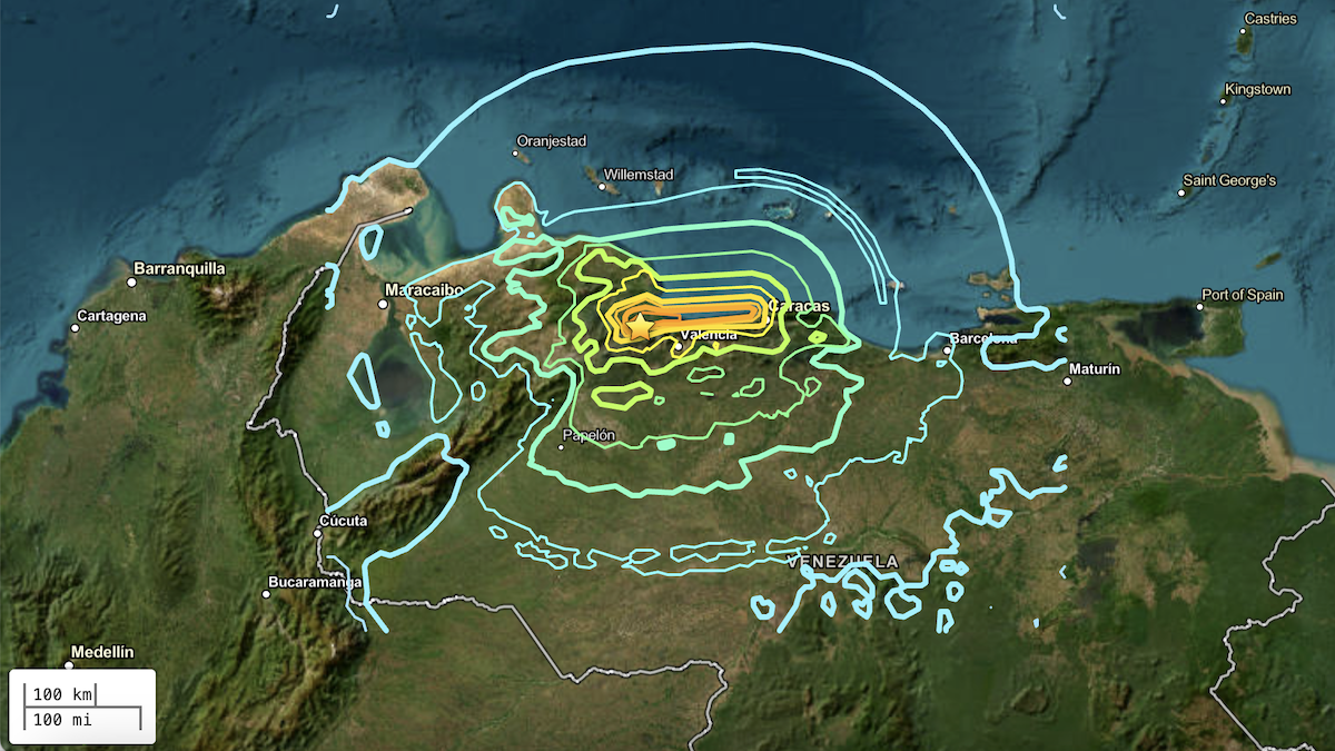
Two powerful earthquakes hit Venezuela within less than a minute on the evening of 24 June, causing widespread damage to buildings, likely spurring landslides, and killing at least 164 people, though the full extent of the damage is still being assessed.
The doublet earthquake consisted of a magnitude 7.2 foreshock followed by a magnitude 7.5 mainshock that struck just 39 seconds later. Both earthquakes’ epicenters were located near Yumare, Venezuela, about 300 kilometers (186 miles) from the country’s capital of Caracas, where millions of people live. According to the U.S. Geological Survey (USGS), many residents of this populous region live in structures made from unreinforced brick masonry and adobe blocks that are not earthquake resistant.
The recent doublet earthquakes occurred at a shallow depth of 10 kilometers (about 6 miles), which likely contributed to the intensity of the shaking.
The USGS has warned that aftershocks could continue to affect the area for days. The agency estimated that within the next week, there is a 99% chance of a magnitude 4 or greater aftershock, a 98% chance of a magnitude 5 or greater aftershock, and a 43% chance of a magnitude 6 or greater aftershock.
Franck Audemard, a structural geologist at the Universidad Central de Venezuela, told colleagues at the Earthquake Insights blog that he’d felt three aftershocks in eastern Caracas as of Wednesday night.
Historic Seismicity
This isn’t the first time in recent history that the region has experienced powerful quakes. A complex network of faults underlies northern Venezuela where the Caribbean and South American tectonic plates meet.
At the plate boundary there exists a strike-slip fault, where sections of rock slide horizontally, parallel to the fault line. This fault, known as the Oca-Ancónor El Pilar fault, moves roughly east-west along Venezuela’s northern coast at approximately 20 millimeters per year. It also creates a junction with the Bonocó fault, which runs northeast-southwest beneath northwestern Venezuela. Both of the recent earthquakes occurred at that juncture, likely along the east-west Oca-Alcón/El Pilar fault, according to Earthquake Insights.
Related
• From Earthquake Insights: Catastrophic M7.5 Earthquake Strikes Northern Venezuela
• From The Landslide Blog: Landslides and liquefaction from the 24 June 2026 “double tap” earthquakes in Venezuela
Large earthquakes have occurred at or near this juncture before. In 1900, a magnitude 7.7 earthquake struck near Caracas, and there have been seven earthquakes with magnitudes greater than 6 over the past century. But the recent earthquakes are the largest to affect the region since the 1900 event.
—Grace van Deelen (@gvd.bsky.social), Staff Writer
These updates are made possible through information from the scientific community. Do you have a story about science or scientists? Send us a tip at [email protected].
