Source: Water Resources Research
Mapping all of the world’s rivers, creeks, and streams is a daunting task, particularly in places like the Arctic, where accurate topographic data are hard to obtain. Scientists now have created a new map of global rivers based on a largely automated computer algorithm that can accurately predict where rivers flow—a tool that could help project future flooding as Earth’s climate changes.
Many different factors affect the flow of water over land, including terrain steepness, watershed size, and human-built structures like canals. Scientists have previously used topographic data collected by spacecraft such as NASA’s Shuttle Radar Topography Mission to generate detailed, 3-D models of Earth’s surface, but these maps sometimes distort the slope of local terrain due to observation errors.
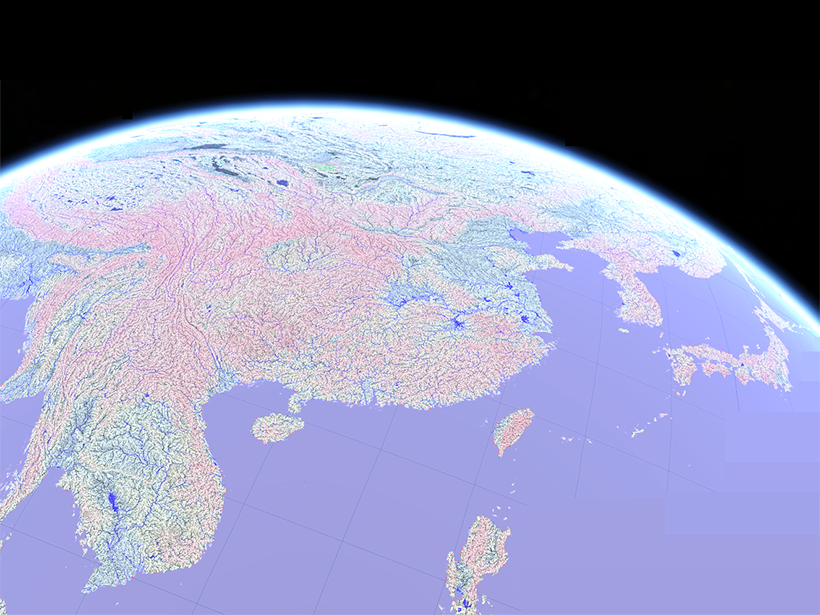
In the new study, Yamazaki et al. used an updated version of a popular topographic data set called the Multi-Error-Removed Improved-Terrain Digital Elevation Model (MERIT DEM), which was published in 2017 by members of the same team, to develop a computer algorithm that predicts where rivers flow with very little human guidance. The new, publicly available hydrographic data set, called MERIT Hydro, reveals rivers at high resolution in approximately 90- × 90-meter gridded pixels, includes the Arctic region, and is less prone to errors caused by tree canopies or inaccurate elevation than existing global hydrographic maps, the authors write. Compared with existing maps, the synthetic hydrographic maps made remarkably accurate predictions of where rivers, such as China’s Pearl River and the Ob River in Russia, should be, the team reported.
To further refine the map, the team also included global Landsat data, as well as data from the crowdsourced mapping database OpenStreetMap, which the researchers searched using tags such as “waterway,” “river,” “stream,” “brook,” and “wadi.” On the basis of this combined data set, the algorithm integrated information on small streams not captured by current satellite images. The OpenStreetMap data also allowed the researchers to generate maps of human-made stream networks, like irrigation canals, that could be flood prone.
A remaining challenge for more accurate river mapping is in arid regions such as the Danakil Desert in Ethiopia, where streams are often intermittent and ephemeral, the researchers noted.
The team writes that it hopes other scientists will build upon and improve the free, open-source MERIT Hydro program, noting that it could be used in predicting flood risks and analyzing ecosystem biodiversity and carbon emissions. (Water Resources Research, https://doi.org/10.1029/2019WR024873, 2019)
—Emily Underwood, Freelance Writer
Citation:
Underwood, E. (2019), A more accurate global river map, Eos, 100, https://doi.org/10.1029/2019EO128033. Published on 12 July 2019.
Text © 2019. The authors. CC BY-NC-ND 3.0
Except where otherwise noted, images are subject to copyright. Any reuse without express permission from the copyright owner is prohibited.