Source: Geophysical Research Letters
Previous studies have reported that global sea level is, on average, rising and that the rate of increase has accelerated since about 1990. However, these studies often disagree on the pace at which this change is occurring.
The reason may be due in part to the focus on average global sea level despite the fact that the various contributors to this acceleration—such as variations in ocean circulation, differences in salinity and temperature, and the melting of glaciers or ice sheets—frequently vary by location.
To get a better handle on the relative importance of the spatial variability of sea level change along North America’s East Coast, Davis and Vinogradova performed a two-step analysis. The team first analyzed a series of long-term annual tidal gauge records to estimate the acceleration of sea level rise from 1955 to 2014, a time span that enabled a more accurate determination of the pace of acceleration.

Next, the team tried to account for the observed changes by developing a new model that simulates the combined effects of four separate contributors to sea level acceleration, all of which vary geographically. These contributions involve melting of the Antarctic and Greenland ice sheets, ocean dynamic processes, and atmospheric surface pressure variations.
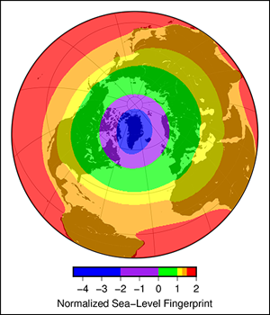
The results indicate that although there is almost no geographic variability in sea level acceleration along the East Coast due to the melting of the Antarctic Ice Sheet, the acceleration due to the melting Greenland Ice Sheet varies substantially. South of roughly 40°N latitude, the contribution from melting Greenland ice comprises a significant portion of the observed acceleration in sea level. North of this parallel, the contribution from physical ocean processes dominates. In short (and perhaps counterintuitively), mass loss from the Greenland Ice Sheet affects sea level rise on coasts farther afield because of the elastic loading of Earth and changes to its gravity field.
According to the researchers, the results of this study bolster confidence that the recent acceleration in sea level rise observed along the East Coast is indeed occurring and improve our understanding of its causes, a crucial step toward improving the accuracy of future sea level rise predictions in this highly populated and economically important region. (Geophysical Research Letters, https://doi.org/10.1002/2017GL072845, 2017)
—Terri Cook, Freelance Writer
Citation:
Cook, T. (2017), Accounting for accelerated East Coast sea level rise, Eos, 98, https://doi.org/10.1029/2017EO076381. Published on 23 June 2017.
Text © 2017. The authors. CC BY-NC-ND 3.0
Except where otherwise noted, images are subject to copyright. Any reuse without express permission from the copyright owner is prohibited.

