
Source: Paleoceanography
The United Kingdom was once a lush oasis. That can be read from sediments within the Kimmeridge Clay Formation, which were deposited around 160 to 145 million years ago on Dorset’s “Jurassic Coast.” A favorite stomping ground for fossil hunters and the source rock for North Sea oil, the formation is rich in organic matter, which suggests that it likely formed when global greenhouse conditions were at least 4 times higher than present levels.
Normally, organic matter disappears rapidly after an organism dies, as the nutrients are consumed by other life forms and the carbon decays. However, when the seas are starved of oxygen, which occurs when plankton numbers swell owing to increasing levels of carbon dioxide, then organic matter is preserved. An abundance of so-called black shales, or organic-rich muds, within the Kimmeridge Clay Formation points to this past.
Here Armstrong et al. used those black shales to build new climate simulations that better approximate the climate toward the end of the Jurassic period. The model simulated 1422 years of time that suggested a radically different Intertropical Convergence Zone—the region where the Northern and Southern Hemisphere trade winds meet—than the one today. The convergence of these trade winds produces a global belt of clouds near the equator and is responsible for most of the precipitation on Earth.
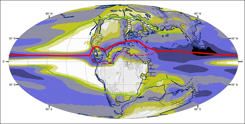
Today the Intertropical Convergence Zone in the Atlantic strays, at most, 12° away from the equator. However, 145 million years ago, when the continents were still much closer together, the model showed that the zone split, like a fork in the road, where the Pacific Ocean met the western coast of the American continents. The zone was driven apart by the proto-Appalachian mountain range to the north and the North African mountains to the south. The northern fork, which was much stronger than the southern one, extended as far as about 30° north, passing over the United Kingdom and the location of the Kimmeridge Clay Formation.
Not only were the researchers able to verify that the United Kingdom was once a tropical oasis, but they were also able to simulate and map the climate 145 million years ago—research that will help scientists better understand how Earth will react to anthropogenic warming today and in the future. (Paleoceanography, doi:10.1002/2015PA002911, 2016)
—Shannon Hall, Freelance Writer
Citation:
Hall, S. (2016), Simulating the climate 145 million years ago, Eos, 97, https://doi.org/10.1029/2016EO060569. Published on 10 October 2016.
Text © 2016. The authors. CC BY-NC-ND 3.0
Except where otherwise noted, images are subject to copyright. Any reuse without express permission from the copyright owner is prohibited.