Source: Journal of Geophysical Research: Solid Earth
Mainland China sits atop one of the most tectonically active regions of the world—the eastern Eurasian plate. To the east, the Pacific and Philippine Sea plates crash into Eurasia. And to the south, the Indian plate collides with the continent, building both the Himalaya and Tien Shan mountain ranges and breaking the lithosphere beneath continental China into tectonic blocks. Ruptures can occur along the boundaries of these blocks, resulting in large earthquakes that occur relatively frequently in the region, putting infrastructure and human lives at risk.
The threat to humans adds a layer of urgency to research on crustal deformation in the region: Understanding hazards is the first critical step to mitigating them.
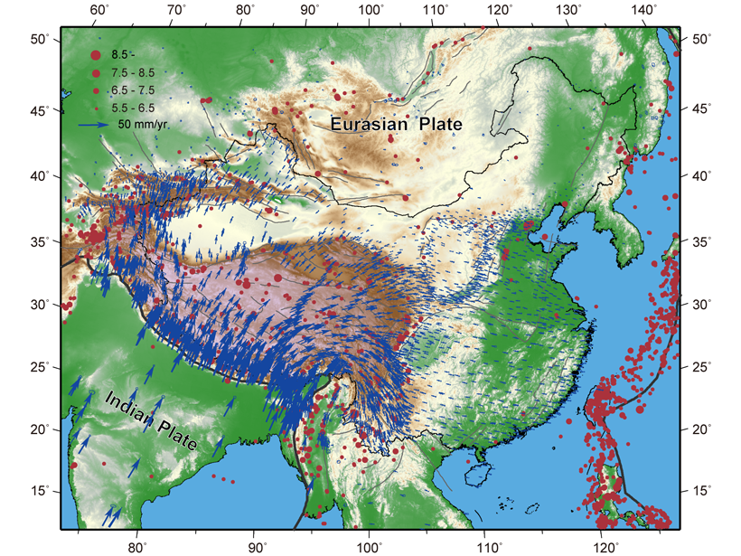
In recent years, space-based technologies like GPS have revolutionized research on the deformation of Earth’s crust, but as the technology improves and coverage expands, GPS-based studies must be updated. In a new study, Wang and Shen present the largest data set to date of GPS-derived velocity measurements describing the movement of continental China’s tectonic blocks. The GPS data were sourced from the Crustal Movement Observation Network of China and from regional GPS networks, which covered thousands of sites and date back 2 decades.
The team applied an algorithm to the GPS data set to obtain velocities with high spatial resolution. The authors accounted for the effects of large earthquakes on the deformation field by modeling coseismic and postseismic displacements of the tremors. The team used the GPS velocities to determine strain rates in the crust, which can be used to identify deformation sources and seismic hazards.
The authors find that deformation rates vary across eastern China, with the highest seismicity and deformation rate occurring in the North China Block. Deformation in the Tibetan Plateau and Tien Shan is largely continuous. The study confirms an eastward stretching of the plateau, which spreads at rates of up to roughly 20 millimeters per year between the Jiali and Ganzi-Yushu faults. Moreover, the researchers find evidence for a long-hypothesized but little-documented westward stretching of the plateau, which occurs at up to 6 millimeters per year in the Hindu Kush region. Altogether, the study provides the most robust and comprehensive analysis of crustal deformation in China to date. (Journal of Geophysical Research: Solid Earth, https://doi.org/10.1029/2019JB018774, 2020)
—Kate Wheeling, Science Writer
Citation:
Wheeling, K. (2020), Space-based data expand understanding of crustal deformation, Eos, 101, https://doi.org/10.1029/2020EO141926. Published on 27 March 2020.
Text © 2020. AGU. CC BY-NC-ND 3.0
Except where otherwise noted, images are subject to copyright. Any reuse without express permission from the copyright owner is prohibited.