Source: Geophysical Research Letters
Pine Island Glacier and its nearby twin, Thwaites Glacier, sit at the outer edge of the West Antarctic Ice Sheet. Like corks in a bottle, the two glaciers block ice flow and keep nearly 10% of the ice sheet from draining into the sea.
Studies have suggested that the West Antarctic Ice Sheet is particularly unstable and could collapse within the next 100 years. The collapse could lead to a sea level rise of nearly 10 feet (3 meters), which would engulf major U.S. cities such as New York and Miami and displace 150 million people living on coasts worldwide.
A nearly 225-square-mile (588-square-kilometer) iceberg—nearly the size of Chicago—broke off from Pine Island Glacier in 2015, but it wasn’t until researchers were testing some new image-processing software that they noticed something strange in Landsat 8 satellite images taken before the event.
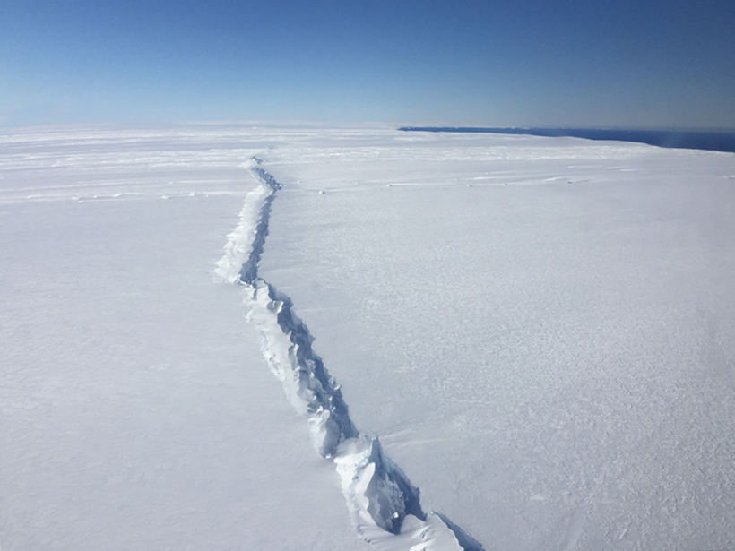
In the images, Jeong et al. saw a rift open in the surface of the ice shelf nearly 20 miles (32 kilometers) inland in 2013. The rift grew over 2 years until it set the iceberg adrift over 12 days in late July and early August 2015. During this period, another, similar rift opened 6 miles (10 kilometers) farther inland of the first.
Rifts usually form at the sides of an ice shelf where the ice is thin and subject to shearing that rips it apart. But this particular rift originated in the center of Pine Island Glacier’s ice shelf and propagated out to the margins.
This implies that something weakened the center of the ice shelf. The most likely explanation is that a crevasse melted out at the bedrock level, driven by a warming ocean, according to the researchers.
Another clue that the center of the ice shelf is weak is that the rift opened in the bottom of a “valley” in the ice shelf where the ice had thinned compared to the surrounding ice shelf. The valley is likely a sign of something researchers have long suspected: Ocean water can intrude far inland and remain unseen because the bottom of the West Antarctic Ice Sheet lies below sea level.
The origin of the rift would have gone unseen, too, except that the images that the researchers analyzed happened to be taken when the Sun was low in the sky. Long shadows cast across the ice drew the team’s attention to the valley that had formed there.
Although this is the first time researchers have witnessed a deep subsurface rift opening within Antarctic ice, they have seen similar breakups in the Greenland Ice Sheet, in spots where ocean water has seeped inland along the bedrock and begun to melt the ice from underneath. The satellite images provide the first strong evidence that these large Antarctic ice shelves respond to changes at their ocean edge in a way similar to that observed in Greenland.
The researchers note that this kind of rifting behavior provides another mechanism for rapid retreat of these glaciers, adding to the probability that there may be a significant collapse of the West Antarctic Ice Sheet in the next century. They point out that there are many similar valleys farther up the glacier. If these sites are prone to rifting, we could potentially see more accelerated ice loss in Antarctica. (Geophysical Research Letters, doi:10.1002/2016GL071360, 2016)
—Lauren Lipuma, Contributing Writer
Citation:
Lipuma, L. (2017), West Antarctic ice shelf breaking up from the inside out, Eos, 98, https://doi.org/10.1029/2017EO064743. Published on 04 January 2017.
Text © 2017. The authors. CC BY-NC-ND 3.0
Except where otherwise noted, images are subject to copyright. Any reuse without express permission from the copyright owner is prohibited.