Source: Journal of Geophysical Research: Atmospheres
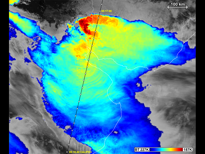
When a severe thunderstorm struck over Argentina on 23 December 2009, satellite instruments captured data-rich images of some interesting cloud layers above the storm. In particular, scientists struggled to explain the processes behind the development of gull wing–shaped cirrus clouds—thin, wispy layers of ice crystals that typically form at altitudes above 6000 meters—above the storm.
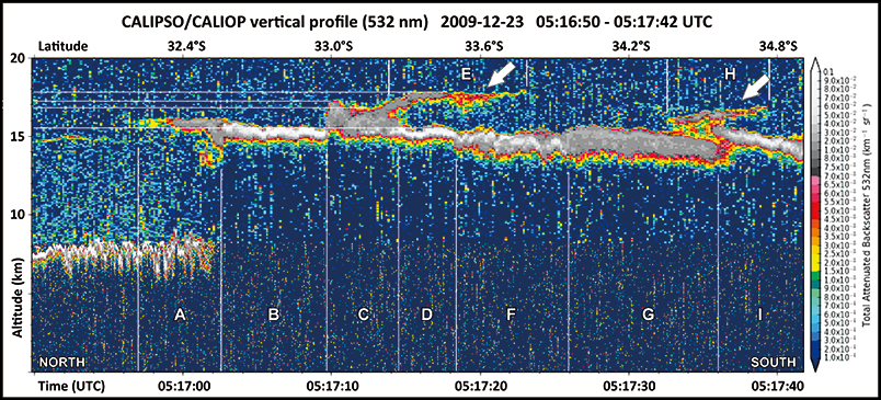
Wang et al. assessed satellite images and model simulations in an effort to determine the mechanisms behind the distinctive formation. The scientists looked at data from the Cloud-Aerosol Lidar with Orthogonal Polarization (CALIOP) instrument on board NASA’s Cloud-Aerosol Lidar and Infrared Pathfinder Satellite Observation (CALIPSO) satellite, which, by measuring how laser pulses reflect off surfaces below, is able to detect the cirrus clouds’ small, optically thin particles above the top of the thunderstorm. The team also used complementary data from NASA’s CloudSat satellite, which is equipped with the longer-wavelength cloud profiling radar (CPR) to penetrate the optically thick storm top. In combination, the satellites offer a more complete picture of the storm and its cirrus layer.
Fortunately for the researchers, a similar supercell storm occurred on 2 August 1981 in the U.S. Midwest, allowing them to compare the satellite data with the results of a model simulation based on the 1981 storm. They simulated the data using a double-moment cloud model, the Wisconsin Dynamic and Microphysical Model (WISCDYMM-II), which predicts the mixing ratio and concentration of water substances to simulate the dynamics and thermodynamics of storms.
Their results indicate that gull wing cirrus clouds occur when internal gravity waves break, pushing moisture into the stratosphere. Internal gravity waves in the atmosphere behave like waves in a pond after a pebble plops in but generally derive from atmospheric disturbances like wind shear or thunderstorms and can propagate vertically. In this case, the cirrus clouds mirrored the gull wing shape created by the the rippling gravity wave.
According to the researchers, these clouds indicate that gravity waves are capable of carrying storm materials much higher than expected. They also stress the need for a global survey of the time and spatial distribution of internal gravity waves driven by deep convection. Because water vapor is a potent greenhouse gas, studying how moisture behaves in the atmosphere will be crucial to understanding our global climate, the authors note. (Journal of Geophysical Research: Atmospheres, doi:10.1002/2015JD024111, 2016)
—Lily Strelich, Freelance Writer
Citation:
Strelich, L. (2016), When thunderstorms have wings, Eos, 97, https://doi.org/10.1029/2016EO054323. Published on 21 June 2016.
Text © 2016. The authors. CC BY-NC-ND 3.0
Except where otherwise noted, images are subject to copyright. Any reuse without express permission from the copyright owner is prohibited.