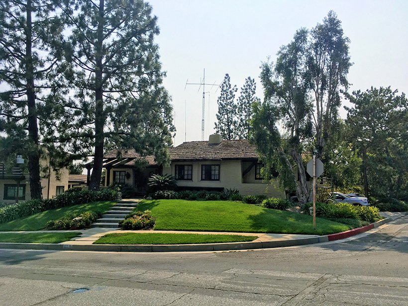
If you’ve ever seen tall antennas rising from everyday residences in your community and wondered what they are for, it could be that those homes belong to ham radio enthusiasts who enjoy communicating with each other over the airwaves. In addition to having fun with their radios and finding camaraderie, many ham radio operators are also prepared to help neighbors and authorities communicate during disasters. One such group of radio enthusiasts is poised now to serve yet another important role: They will be contributing to a more robust delivery mechanism for critical seismic intensity reports after major earthquakes through the U.S. Geological Survey’s (USGS) Did You Feel It? (DYFI) system.
Twenty Years, Millions of Reports
DYFI is a popular way for the public to help document macroseismic shaking intensity—if your answer to “Did you feel it?” is yes, it was macroseismic shaking—and contribute to earthquake science. The magnitude 5.1 earthquake that hit rural North Carolina on 9 August 2020, for example, resulted in more than 100,000 responses submitted to the DYFI system from people residing in more than 15 states.
In addition to the scientific value of Did You Feel It? (DYFI) intensity reports, studies have shown that this type of civic engagement by the public improves awareness of natural hazards.
DYFI involves a user answering a questionnaire about their experience and observations—from which USGS determines the shaking intensity at that person’s location—and has been in operation for 2 decades (1999–2020) in the United States and for nearly 15 years globally. In that period, USGS has amassed more than 5 million individual DYFI intensity reports, spanning wide ranges of intensities and felt distances. In addition to the scientific value of this collection, studies have shown that this type of civic engagement by the public improves awareness of natural hazards [Celsi et al., 2005]. For example, DYFI engagement can help clarify the difference between earthquake intensity (the effects and strength of shaking at a specific location) and magnitude (related to the area and distance of slip on a fault).
DYFI is also used to help constrain USGS ShakeMap, an important tool for situational awareness and emergency management widely used to depict an earthquake’s shaking distribution and its likely effect on communities. For instance, the U.S. Federal Emergency Management Agency (FEMA) uses ShakeMap (and thus DYFI) to estimate losses immediately following damaging earthquakes in the United States to guide and expedite state and national disaster declarations.
Macroseismic intensity data collected through the DYFI system have proven to be accurate time and time again. At lower intensity levels, answers to the online questionnaire allow scientists to quantify the fraction of observers that felt an earthquake and where they felt it. At higher intensities, objective observations—such as whether objects fell off shelves—are prime indicators of absolute shaking levels. Other indices, such as qualitative felt levels (e.g., not felt, weak, mild, moderate, strong, violent), are categorized, as is often done in social science surveys, so that consistent numerical scores can be assigned to such perceptions [e.g., Goltz et al., 2020].
DYFI responses sometimes exceed 70 submissions per second, and typically, about 90% of DYFI reports are acquired within 60 minutes of an earthquake.
Scores of scientific papers rely on DYFI data to study earthquake shaking [e.g., Atkinson and Wald, 2007; Quitoriano and Wald, 2020, and references therein]. The reliability of these studies is due in part to the high quality of DYFI data and in part because DYFI can fill gaps where instrumental data are lacking but residents have access to cell phones and the Internet. In fact, DYFI data are often more accurate than seismometers for assessing damage because they provide actual reports (say, of chimney damage), whereas data from seismic instruments require inference to determine the likelihood of such damage. Naturally, the more DYFI reports that come in, the more robust intensity assignments become because many observations can be better analyzed statistically.
Unlike social media sourcing, which can provide useful first-person accounts during disasters, DYFI reports provide immediate, specific, and quantifiable intensity values deemed authoritative by the U.S. government. Critically, social media content requires careful curation, especially when large volumes of indiscriminate content are produced during a crisis situation. Twitter and online posts are informative but are more difficult to parse and use quantitatively or in an official capacity [e.g., Earle et al., 2011].
By contrast, DYFI, as a targeted questionnaire aimed at answering specific questions about shaking and damage, can be automatically processed and sent to ShakeMap to convey shaking and potential impacts. Remarkably, rates of DYFI responses sometimes exceed 70 submissions per second, and typically, about 90% of DYFI reports are acquired within 60 minutes of an earthquake.
Sampling the “Donut Hole”
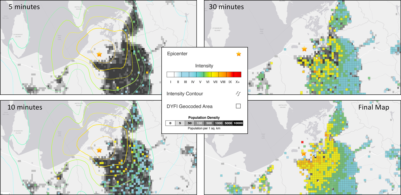
A potential problem with the DYFI system is that public access to it may be compromised as a result of strong earthquake shaking. Those affected may experience electrical power outages and limited Internet and cellular access, or they may have other immediate priorities, such as checking on those around them. USGS and other global seismic network operators have witnessed felt report “donut holes” in areas of strong shaking due to loss of Internet communication [Bossu et al., 2018], most recently during the M5.7 earthquake that hit near Salt Lake City in March 2020 (Figure 1). Alternative pathways are thus needed to gather important ground truth shaking data with minimal delay. To this end, we have recently come up with a plan B.
We now expect to sample the donut hole with the help of amateur radio groups worldwide. These groups, which already provide emergency communications capabilities to government agencies, hospitals, and other critical users during emergencies and disasters, can mobilize a significant number of licensed radio operators after a strong earthquake, especially near large population centers, ensuring a baseline level of macroseismic intensity reporting even in heavily affected areas.
To take advantage of this capability, USGS has partnered with Winlink, a radio email platform with more than 28,000 users worldwide, and with members of the Amateur Radio Emergency Service (ARES). In June 2020, Winlink experts adapted the USGS DYFI questionnaire to their software platform, and this version is now available to all licensed amateur radio operators. During a major earthquake, Winlink users can send their responses via radio to faraway receiving stations if their local Internet connectivity is compromised. These unaffected, out-of-area stations, or gateways, can then forward data via the Internet to USGS for immediate analysis.
Disaster Response, Past and Future
Amateur radio provides robustness and redundancy in the event of major communications failures.
Amateur radio provides robustness and redundancy in the event of major communications failures, such as those experienced during the devastating 2017 Puebla, Mexico, earthquake and during Hurricanes Katrina, Irma, and Maria. During these events, Twitter and other social media platforms were unavailable locally. But amateur radio operators in the affected areas sent email via radio without local telecommunications infrastructure, often over hundreds or thousands of kilometers to unaffected gateways.
The ARES system is built to operate under such dire conditions: ARES responders are preregistered, have precise location information, and have verifiable identities. They also have training in other duties during emergency situations, such as facilitating communications among hospitals to help triage incoming patients and share resources, so they are more likely to submit high-quality data during an emergency.
The donut hole observed after the 2020 Salt Lake City earthquake (which was actually shaped more like a croissant) was small in scale, and although residents inside that area lost electrical power, the effects of the shaking were limited overall, and only light damage was reported [e.g., Kleber et al., 2021]. In contrast, effects will be far heavier over much larger areas during a major event.
The United States has not yet experienced a large earthquake domestically in the age of social media and has not experienced an event with devastating consequences for roughly a century (e.g., the direct metropolitan hits by the 1906 magnitude 7.8 Great San Francisco earthquake and the 1933 magnitude 6.3 Long Beach earthquake, which greatly affected Los Angeles). In such events in the future, scientists and emergency planners anticipate large-scale, complex, and unpredictable losses in communications. Amateur radio operators can bridge gaps and provide reliable on-the-ground observations from affected areas in a timely manner when other means of communications are offline.
Send in the COWs
Amateur radio is also uniquely flexible when it comes to choosing communications paths. In addition to their more traditional very high frequency (VHF) and high-frequency (HF; i.e., radio frequency) networks, operators have also built local high-speed data-voice (mesh) networks, which can interface with satellite-connected cells on wheels (COWs).
The Amateur Radio Emergency Service recently provided its services to the Monterey Park, Calif., Fire Department during the 2019 ShakeOut earthquake scenario exercise.
Communications companies use COWs at sporting events to provide additional network capacity, but they can be used similarly during disasters, as was demonstrated during the 2017 Thomas Fire and the 2018 Camp Fire, both in California. Other organizations, like FEMA and the Salvation Army, have their own COWs.
ARES has leveraged mesh networks to provide local Voice over Internet Protocol (VoIP) and video feeds in addition to Winlink (which works on these networks just as well). Most recently, ARES provided these services for the Monterey Park Fire Department in California during the 2019 ShakeOut earthquake scenario exercise. However, email and voice communications amateur radio frequencies on VHF and HF are more than sufficient for most situations, and DYFI for Winlink has been designed to be sent via VHF, HF, and mesh.
Standing By to Help
To develop backup plan B for DYFI, Winlink worked with USGS to implement the DYFI questionnaire with a DYFI-compatible ARES form. The questionnaire is now available to all ARES users, and the ARES/Winlink/DYFI connection has been widely tested in earthquake exercises and recent real events. The ARES/DYFI reports fit seamlessly with standard entries submitted via the Internet to the DYFI system.
ARES has promoted the new global radio email DYFI protocol through various media and has created a training video for ARES users. The organization has also set up training sessions and exercises among various radio operator communities in California, Washington, Arizona, Hawaii, and Mexico to test and promote the new form.
Internet-based access to DYFI as well as social media platforms may be compromised after a major seismic event. But the widely dispersed members of ARES are now standing by to help in the case of consequential earthquakes anywhere in the world. In such an event, those antennas towering above your neighbor’s home may just be a lifeline that helps emergency personnel come to the rescue.
Acknowledgments
The development of this Winlink DYFI form was made possible through a collaboration between USGS, the Winlink Development Team, and ARES LAX (Amateur Radio Emergency Service, Los Angeles). Any use of trade, firm, or product names is for descriptive purposes only and does not imply endorsement by the U.S. government.
References
Atkinson, G. M., and D. J. Wald (2007), “Did You Feel It?” intensity data: A surprisingly good measure of earthquake ground motion, Seismol. Res. Lett., 78, 362–368, https://doi.org/10.1785/gssrl.78.3.362.
Bossu, R., et al. (2018), Felt reports for rapid mapping of global earthquake damage: The doughnut effect?, Seismol. Res. Lett., 89, 138–144, https://doi.org/10.1785/0220170129.
Celsi, R., M. Wolfinbarger, and D. J. Wald (2005), The effects of earthquake measurement concepts and magnitude anchoring on individuals’ perceptions of earthquake risk, Earthquake Spectra, 21(4), 987–1,008, https://doi.org/10.1193/1.2099047.
Earle, P. S., D. C. Bowden, and M. Guy (2011), Twitter earthquake detection: Earthquake monitoring in a social world, Ann. Geophys., 54(6), 708–715, https://doi.org/10.4401/ag-5364.
Goltz, J. D., et al. (2020), Earthquake ground motion and human behavior: Using DYFI data to assess behavioral response to earthquakes, Earthquake Spectra, 36(3), 1,231–1,253, https://doi.org/10.1177/8755293019899958.
Kleber, E. J., et al. (2021), Geologic setting, ground effects, and proposed structural model for the 18 March 2020 Mw 5.7 Magna, Utah, earthquake, Seismol. Res. Lett., https://doi.org/10.1785/0220200331.
Quitoriano, V., and D. J. Wald (2020), USGS “Did You Feel It?”—Science and lessons from 20 years of citizen science-based macroseismology, Frontiers Earth Sci., 8, 120, https://doi.org/10.3389/feart.2020.00120.
Author Information
David J. Wald ([email protected]), U.S. Geological Survey, Golden, Colo.; Vincent Quitoriano, U.S. Geological Survey, San Diego, Calif.; and Oliver Dully, Amateur Radio Emergency Service, Pasadena, Calif.
Citation:
Wald, D. J.,Quitoriano, V., and Dully, O. (2021), Amateur radio operators help fill earthquake donut holes, Eos, 102, https://doi.org/10.1029/2021EO155013. Published on 22 February 2021.
Text not subject to copyright.
Except where otherwise noted, images are subject to copyright. Any reuse without express permission from the copyright owner is prohibited.