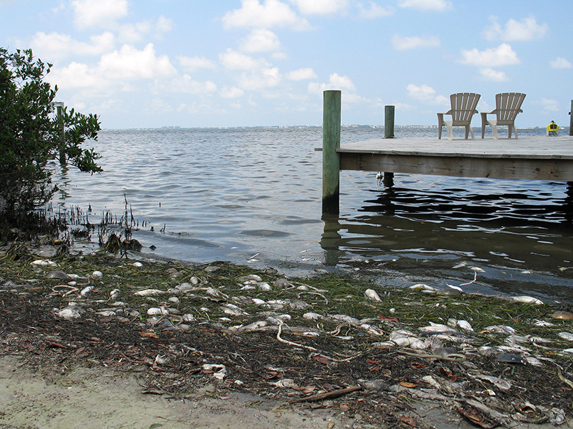
The world population was estimated at more than 7 billion people as of 2015, and roughly half of them live within 100 kilometers of a coastline [United Nations Environment Program, 2007]. Human population growth and climate change have put increasing pressure on coastal ecosystems. To ensure that humans can adapt to changes in these ecologically and economically important ecosystems, it is essential that we understand the factors that affect their water quality, ecological processes, and biogeochemical cycles.
The waters of coastal ecosystems are also complex because of their proximity to land—and by extension to the humans who inhabit the coastlines.
Coastal ocean ecosystems are more complex than open-ocean ecosystems because currents, tides, surface winds, and light drive short-term variability in chemical and biological processes, including phytoplankton growth and migration. The waters of coastal ecosystems are also complex because of their proximity to land—and by extension to the humans who inhabit the coastlines. This proximity subjects coastal ecosystems to variations in materials carried in river and groundwater flow, along with varying stress from human activities.
The value of coastal ecosystems and the pressures on them motivated, in part, the National Research Council [2007] to recommend in their Earth science decadal survey that NASA develop a satellite mission to monitor coastal stressors. In particular, the National Research Council recommended the Geostationary Coastal and Air Pollution Events (GEO-CAPE) satellite mission, which at the time was in early planning stages and was formally initiated in 2008. In addition to focusing on pollution events, GEO-CAPE would observe dynamic coastal ocean processes and variability in atmospheric composition across the United States.
Atmospheric objectives are described by Fishman et al. [2012]. Here we describe the coastal ecosystem part of the mission, which would investigate science questions centered on short-term biogeochemical processes, exchanges between land and ocean, the effects of climate change and human activity, the effects of airborne materials, and episodic pollution events and coastal hazards. By imaging the same regions repeatedly throughout the day, GEO-CAPE would offer an unprecedented look at these short-term phenomena.
The GEO-CAPE Mission
In 2008, two science working groups that focused separately on the ocean and the atmosphere convened to address land, ocean, and atmospheric processes and their interactions across terrestrial and aquatic interfaces. Members of these working groups, who were chosen from university experts and NASA personnel, began to formulate the specifics of GEO-CAPE.
GEO-CAPE has preformulation status. This means that NASA is funding efforts to create robust mission plans and instrument designs but is waiting on these plans and designs before setting a launch date, pending future funding. The original science working groups have defined scientific questions and continue to advise NASA on the spatial, spectral, temporal, and radiometric attributes for the GEO-CAPE mission.
Critically, GEO-CAPE would conduct remote sensing from a geostationary orbit, which would provide the necessary perspective for repeated observations of geographic regions of interest throughout the day. This orbit is a key factor in how GEO-CAPE would be different from the present suite of low Earth orbit ocean color satellites.
To reduce mission risk and cost, the working groups have endorsed the concept of phased implementation, or separate launches, of the ocean and atmospheric Earth-observing instruments, using hosting on commercial satellites. Although GEO-CAPE has an unspecified launch date, NASA has invested nearly $20 million to advance the science and technology of the mission. GEO-CAPE would be a two- or three-instrument payload mission with a distributed architecture to reduce risk and cost.
GEO-CAPE’s Ocean Color Sensor
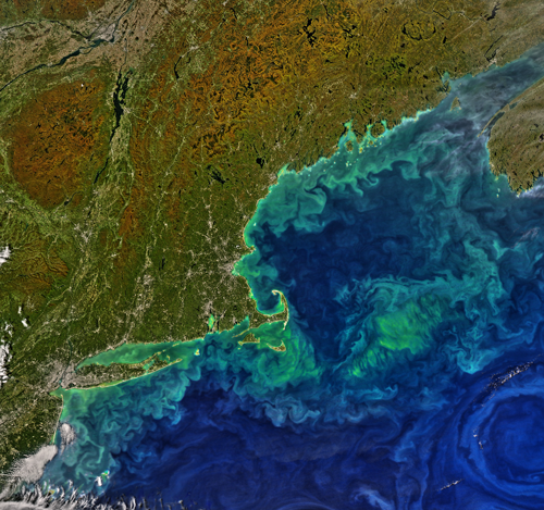
Ocean color information can aid in identifying algal blooms, colored dissolved materials, particle loads, and oil spills. It can also provide information on land use and coastal features and reveal changes in response to storms and other disruptive phenomena. Thus, GEO-CAPE would track phytoplankton, water quality, and biogeochemical parameters across northern and southern latitudes in the Western Hemisphere.
To achieve its scientific goals, the GEO-CAPE team developed the concept for an ocean color sensor uniquely designed to capture the evolution of algal blooms and monitor phytoplankton physiology, growth rates, and shifts in phytoplankton community composition. The sensor would also resolve coastal features, fronts, eddies, and upwelling and help to estimate biogeochemical fluxes and land-ocean-atmosphere exchanges at subdiurnal and multiday scales. The sensor would feature a hyperspectral ocean color radiometer that senses energy emanating from the coastal ocean in the ultraviolet, visible, and near- and shortwave-infrared spectral ranges.
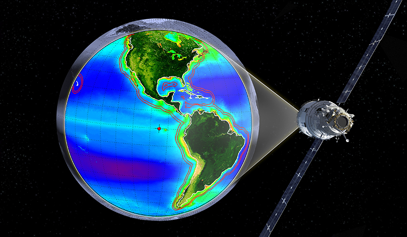
Geostationary orbit would keep the sensor at a fixed location approximately 36,000 kilometers above the Earth (Figure 1). This would allow frequent imaging within its fixed field of view of North and South America’s vast coastal regions and the Laurentian Great Lakes, providing frequent measurements that would revolutionize scientific understanding of coastal dynamics and dramatically increase the societal value of coastal observations from space.
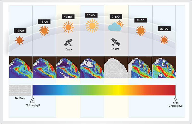
Current ocean color sensors on polar orbiters can make measurements of the coastal ocean only once every 1–2 days. Because of cloud cover and other limitations, valid ocean color retrievals over coastal waters occur weekly, on average, which is inadequate to quantify coastal ocean dynamics. GEO-CAPE’s high-frequency measurements (every 1 to 3 hours) would resolve rapidly changing conditions in coastal waters, making it possible to monitor and quantify ecosystem processes and to reduce measurement uncertainties (Figure 2).
By focusing on coastal environments, GEO-CAPE is poised to advance not only ocean science but also terrestrial ecosystem science, which would greatly increase the number of cloud-free observations of diurnal and seasonal changes in coastal vegetation. This improvement would enable new applications for studying agricultural productivity and stress, tidal inundation, disturbance of natural ecosystems, and responses to ephemeral phenomena such as storm events.
In addition, the spectral range and spatial resolution achievable with the sensor would provide data on atmospheric aerosols and potentially trace gases for studies of coastal emissions. These data would allow GEO-CAPE to study interdisciplinary science topics, including biogeochemical cycling in coastal ecosystems, carbon stocks and fluxes from coastal wetlands, coral reef health, coupled coastal air and water quality, the role of upwelling and bioaerosols in meteorology, and effects of anthropogenic disturbances in aquatic environments.
Enhanced Applications
Humans benefit from coastal ecosystems economically and in their quality of life [Wheeler et al., 2012]. To sustain healthy coastal systems, economic prosperity, and quality of life, we will need the ability to monitor change, assess ecological conditions, and disseminate information to the people who need it most.
The GEO-CAPE Ocean Working Group and NASA’s Applied Science Program work closely with the satellite user community, including the National Oceanographic and Atmospheric Administration, the U.S. Environmental Protection Agency, the U.S. Navy, the U.S. Army Corps of Engineers, the Bureau of Ocean Energy Management, and the Gulf of Mexico Fishery Management Council. We have compiled metrics to assess user data needs and measurement requirements for specific applications concepts.
Proposed applications include tracking harmful algal blooms, managing fisheries, assessing water quality, quantifying large oil spill thickness and extent, and improving disaster response.
Following this assessment, proposed applications include tracking harmful algal blooms; managing fisheries; assessing water quality, surface currents, and underwater visibility; improving search and rescue and navigation; monitoring coastal and estuarine acidification; quantifying large oil spill thickness and extent; and improving carbon modeling, environmental forecasting, benthic habitat monitoring, and disaster response.
The ability of GEO-CAPE to monitor anthropogenic emissions and smoke plumes from fires on regional scales throughout the day would offer considerable potential for quantifying changes in coastal air quality, smoke plume evolution, and fire emissions, which have direct and significant effects on atmospheric and biogeochemical cycles, the Earth’s radiation budget, and human lives. Access to information on other important abrupt disturbances—snow and ice melt, river ice damming and spring flush, storm impacts, and coastal flooding—would also aid in resource monitoring and relief distribution. Improved temporal, spatial, and spectral resolution would contribute to coastal land monitoring, including rapid assessments of storm damage to coastal ecosystems, agriculture, human habitation, and businesses.
Recent GEO-CAPE Ocean Activities
GEO-CAPE is on track to join the global constellation of geostationary atmospheric chemistry and coastal ocean color sensors. The working group has carried out several engineering studies and field measurements over the past 5 years to ensure appropriate instrument designs that meet science requirements while maintaining reasonable cost and risk profiles of the GEO-CAPE ocean color sensor.
GEO-CAPE is on track to join the global constellation of geostationary atmospheric chemistry and coastal ocean color sensors.
Satellite stability is a major challenge faced by a remote sensing instrument positioned far above Earth’s surface. The GEO-CAPE instrument must be capable of capturing high-resolution (~250-meter resolution) imagery each hour. To test stability and performance, engineering studies focused on how to keep the instrument stable enough that it can accomplish this task. These studies concluded that spacecraft disturbances affecting the ocean color instrument could be resolved using existing technologies. Oceanographic cruises in the Chesapeake Bay (July 2011) and the northern Gulf of Mexico (September 2013) obtained comprehensive high temporal, spectral, and spatial resolution data sets to capture patterns and scales of variability in coastal water ecosystems. These data sets are needed to evaluate the temporal, spatial, and spectral resolution requirements of the sensor.
Another field experiment (May–June 2016) was designed to collect additional measurements in the field of view of the Korean Geostationary Ocean Color Imager (GOCI), a pathfinder geostationary ocean color satellite currently in orbit. This collaborative field study with Korean scientists focused on diurnal dynamics of dissolved and suspended organic and inorganic materials, with special attention given to ocean color radiometry. These data would be used to evaluate what can be resolved with hourly data in complex coastal environments in preparation for algorithm development for GEO-CAPE.
A Leap Ahead for Coastal Science
With its unique imaging capabilities and vantage point, the GEO-CAPE ocean color sensor would do for coastal science and applications what the Geostationary Operational Environmental Satellite system (GOES) has done for weather prediction. GOES satellites, the most widely used environmental satellites in the world, have led to improved forecasts that save lives, preserve property, and benefit agriculture and have spawned new commercial ventures.
In a similar fashion, a quality geostationary ocean color satellite positioned over the Western Hemisphere would revolutionize the science of coastal processes, allow for more precise ecosystem modeling, and deliver products and information needed for societal health, coastal protection, businesses, and efficient use of Earth’s resources.
Acknowledgments
We gratefully acknowledge the efforts of the GEO-CAPE Oceans, Atmospheric, and Interdisciplinary science working groups. The views expressed in this paper are those of the authors and do not represent the views or policies of the U.S. Environmental Protection Agency or NASA.
References
Fishman, J., et al. (2012), The United States’ next generation of atmospheric composition and coastal ecosystem measurements: NASA’s Geostationary Coastal and Air Pollution Events (GEO-CAPE) mission, Bull. Am. Meteorol. Soc., 93(10), 1547–1566, doi:10.1175/BAMS-D-11-00201.1.
National Research Council (2007), Earth Science and Applications from Space: National Imperatives for the Next Decade and Beyond, Natl. Acad. Press, Washington, D. C.
United Nations Environment Program (2007), United Nations Environment Program annual report, Nairobi.
Wheeler, B. W., M. White, W. Stahl-Timmins, and M. H. Depledge (2012), Does living by the coast improve health and wellbeing?, Health Place, 18, 1198–1201.
Author Information
Joseph Salisbury (email: [email protected]), Ocean Processes Analysis Laboratory, University of New Hampshire, Durham; Curtiss Davis, Oregon State University, Corvallis; Angela Erb, School for the Environment, University of Massachusetts, Boston; Chuanmin Hu, University of South Florida, St. Petersburg; Charles Gatebe, Universities Space Research Association, NASA Goddard Space Flight Center, Greenbelt, Md.; Carolyn Jordan, National Institute of Aerospace, Hampton, Va.; Zhongping Lee, School for the Environment, University of Massachusetts, Boston; Antonio Mannino, Ocean Ecology Laboratory, NASA Goddard Space Flight Center, Greenbelt, Md.; Colleen B. Mouw, Department of Geological and Mining Engineering and Sciences, Michigan Technological University, Houghton; Crystal Schaaf, School for the Environment, University of Massachusetts, Boston; Blake A. Schaeffer, Office of Research and Development, U.S. Environmental Protection Agency, Washington, D. C.; and Maria Tzortziou, Department of Earth and Atmospheric Sciences, City University of New York, N.Y.
Citation:
Salisbury, J.,Davis, C.,Erb, A.,Hu, C.,Gatebe, C.,Jordan, C.,Lee, Z.,Mannino, A.,Mouw, C. B.,Schaaf, C.,Schaeffer, B. A., and Tzortziou, M. (2016), Coastal observations from a new vantage point, Eos, 97, https://doi.org/10.1029/2016EO062707. Published on 14 November 2016.
Text © 2016. The authors. CC BY-NC-ND 3.0
Except where otherwise noted, images are subject to copyright. Any reuse without express permission from the copyright owner is prohibited.