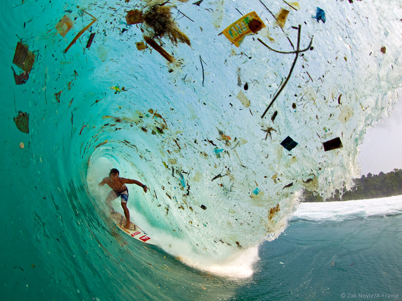
Marine debris has become a huge global problem, and neither governments nor scientific communities are prepared to deal with it. Eighty percent of artificial debris is long-living plastic, which is found nearly everywhere, even in the remote Arctic and Southern Oceans and on the deep ocean floor.
An estimated 8 million tons of plastic debris are added to the ocean annually, but at-sea and on-shore observations find only a tiny fraction of the expected accumulation.
Many fundamental questions about long-lived plastic remain unanswered. For example, an estimated 8 million tons of plastic debris are added to the ocean annually, but at-sea and on-shore observations find only a tiny fraction of the expected accumulation.
Why are observed trends in debris growth much smaller than one would expect from the exponential increase in production? What are the sources, pathways, sinks, balance, lifecycles, and impacts of marine debris? How do the large plastic items break into tiny fragments (microplastics) commonly found in marine mammals, birds, turtles, and fish? There is no observation system in place to answer these and other questions.
To this end, scientists gathered at a workshop in January 2016 at the University of Hawai‘i at Mānoa in Honolulu with the goal of jump-starting development of such a system that could sense marine debris from space. Participants included researchers, citizen scientists, engineers, and cleanup experts from academic institutions, government and nongovernment organizations, and industry. They represented the United States, Japan, The Netherlands, and the United Nations Environment Programme.
No single sensor or platform can “see” all debris varieties; the observational system must consist of sensors specialized for various types of debris in different environments
The diverse group concluded that no single sensor or platform can “see” all debris varieties, and therefore the observational system must consist of different sensors, each specialized for various types of debris in different environments. Thus, traditional optical imagery can be used for the largest debris in selected cloud-free areas; synthetic aperture radar imagery and interferometry is suited for all-weather detections and drift measurements; imaging spectroscopy can detect low concentrations of subpixel-size plastic particles; and Raman spectroscopy, which penetrates below the surface, is useful for measuring debris sunk in shallow seas or suspended in the upper ocean.
Because these technologies are used already for other tasks, meeting participants suggested that they be adapted for marine debris observations pending laboratory and suborbital experiments. They added that suborbital missions could also become a part of the future observing system.
Calibration, validation, and coordination of remote observations will require standardized in situ reports and improved marine debris drift models, attendees noted. Such standardization and improvements are currently hampered by lack of satellite and in situ measurements of surface currents or their accurate parameterizations.
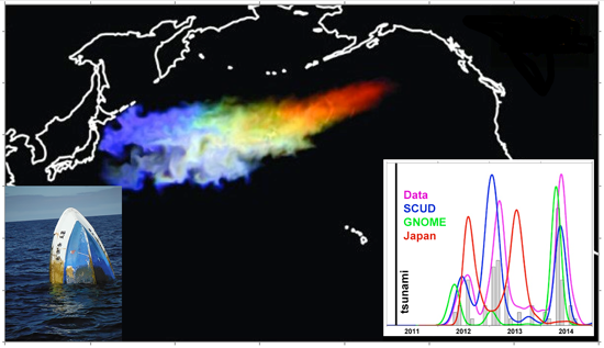
Meeting participants agreed that such a future observing system will help scientists to monitor changes. It could also help policymakers optimize government actions to cope with the general marine debris problem; respond to the aftermath of such major disasters as debris from tsunamis in Indonesia (2004) and Japan (2011); guide such search-and-rescue operations as the one for Malaysia Airlines Flight 370; and identify such new threats to the ecosystem as invasive species transport by debris. Marine debris observations will, furthermore, improve understanding of surface velocities, an important component of the global ocean circulation.
The workshop was funded by the NASA Physical Oceanography Program. Based on meeting results, a white paper was submitted to the Decadal Survey for Earth Science and Applications from Space. Future plans include establishment of a set of focused working groups.
—Nikolai Maximenko, International Pacific Research Center, School of Ocean & Earth Science & Technology, University of Hawaii, Honolulu, Hawaii; email: [email protected]; and Yi Chao and Delwyn Moller, Remote Sensing Solutions, Monrovia, Calif.
Citation:
Maximenko, N.,Chao, Y., and Moller, D. (2016), Developing a remote sensing system to track marine debris, Eos, 97, https://doi.org/10.1029/2016EO061605. Published on 25 October 2016.
Text © 2016. The authors. CC BY-NC-ND 3.0
Except where otherwise noted, images are subject to copyright. Any reuse without express permission from the copyright owner is prohibited.