Last March, nearly 100 geoscientists from state, federal, academic, and private sector institutions in the United States and Canada gathered on the University of Minnesota campus. They presented current research on and discussed issues related to the latest developments in geologic mapping. They also discussed the synthesis of geological and geophysical information into 3-D models of the North American continent on scales varying from urban to continental.
The geoscientists were concerned with mapping capabilities, from surficial materials to Precambrian basement, from young tectonic environments to well-established cratons, from water and mineral resources to natural hazards to basic science and education.
Geologic mapping is an essential service, part of a spectrum of activities that benefit society—from research and monitoring to modeling and resource management.
In his opening plenary, Harvey Thorleifson of the University of Minnesota and the Minnesota Geological Survey briefly reviewed the history of 2-D geologic mapping from paper maps to Internet-accessible databases. He summarized scientific literature that highlighted enhanced data collection through digital capture of field data and the application of geoinformatics and 3-D methods to create maps. These advances have enabled the creation of models that contribute greatly to the science and planning of energy, minerals, water, hazards, and infrastructure design. These models are made possible by improved 3-D mapping that is well coordinated with spatial data infrastructure and well supported by global initiatives. Thorleifson suggested that geologic mapping is an essential service, part of a spectrum of activities that benefit society—from research and monitoring to modeling and resource management.
Other presenters gave examples of the process to develop 3-D geological maps on various scales and the applications and benefits of this mapping:
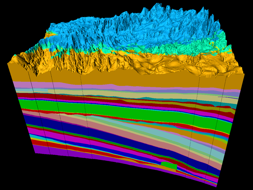
- Kelsey MacCormack of the Alberta Geological Survey presented work on a 3-D geologic model of Alberta that is part of an effort to create a single source of geological information for the benefit of its diverse stakeholder groups (Figure 1).
- Don Sweetkind of the U.S. Geological Survey presented examples of regional groundwater systems, which require a regionally integrated 3-D geologic framework.
- Dick Berg of the Illinois State Geological Survey presented work on 3-D geologic mapping for urban areas, emphasizing the need to protect our local food and water supplies, as well as to help inform subsurface infrastructure.

Attendees recognized the benefits of 3-D geologic mapping and the role that our interconnected electronic world can play to realize and maximize these benefits. They agreed that developing 3-D geologic products that are relevant, accessible, consistent, and readily updatable requires strong coordination among state, federal, academic, and industry partners, as well as a deep appreciation of the needs of potential users.
Attendees were invigorated by the workshop and felt that the Geologic Mapping Forum should continue every 1–2 years and complement the annual Digital Mapping Techniques workshops held each year in late spring. A full workshop summary is available here.
This meeting was hosted by the Minnesota Geological Survey.
—O. S. Boyd (email: [email protected]), U.S. Geological Survey, Golden, Colo.; and L. H. Thorleifson, Minnesota Geological Survey, Minneapolis
Citation:
Boyd, O. S.,Thorleifson, L. H. (2018), Geology in 3-D and the evolving future of Earth science, Eos, 99, https://doi.org/10.1029/2018EO104857. Published on 24 August 2018.
Text not subject to copyright.
Except where otherwise noted, images are subject to copyright. Any reuse without express permission from the copyright owner is prohibited.