
Earth’s magnetic field is far from uniform, and it is constantly changing. Localized, up-to-the-minute information on magnetic field strength contributes to our scientific understanding of our planet and its processes. This information also provides a foundation for numerical models that are vitally important for day-to-day operations in several critical industries.
Navigation data from magnetic models aid directional drilling for oil and gas, for example, which can involve steering a wellbore many kilometers underground. Indeed, many wellbores can be drilled from a single platform, and avoiding wellbore collisions, which might result in blowouts, is a prime safety consideration. Ensuring such accidents do not occur demands high accuracy and precision from magnetic navigation data.
In this era of satellite global magnetic surveys, geomagnetic data from ground-based magnetic observatories—the earliest of which were established in the 1830s—remain a valuable resource.
Geomagnetic data are also a key component of models that simulate how space weather affects ground-based technologies, such as electrical power transmission systems. Temporal changes in the magnetic field caused by space weather create, through Faraday’s law of induction, electrical currents that can damage high-voltage transformers and create voltage instabilities in systems, potentially leading to blackouts.
In this era of satellite global magnetic surveys and precise position and heading data from global navigation satellite systems, geomagnetic data from ground-based magnetic observatories—the earliest of which were established in the 1830s in Europe—remain a valuable resource. Geomagnetic observatory measurements are key data for research into the deep Earth, supporting mathematical modeling of magnetic field changes and of properties and processes in Earth’s core and lithosphere. Permanent geomagnetic observatories provide a clear record of temporal change in the magnetic field at fixed locations around the globe. In contrast, satellite surveys of magnetism must be untangled to separate simultaneous spatial and temporal changes recorded on a moving platform.
In 1991, a global network of digital magnetic observatories called INTERMAGNET (International Real-Time Magnetic Observatory Network) was established to develop and encourage adoption of modern standards in measuring, recording, and transmitting magnetic observatory data. INTERMAGNET is the product of collaboration between nationally funded geomagnetic institutes acting for mutual benefit. Here we describe developments that INTERMAGNET has introduced in recent years to continue to serve geomagnetic data consumers.
A Worldwide Network of Observatories
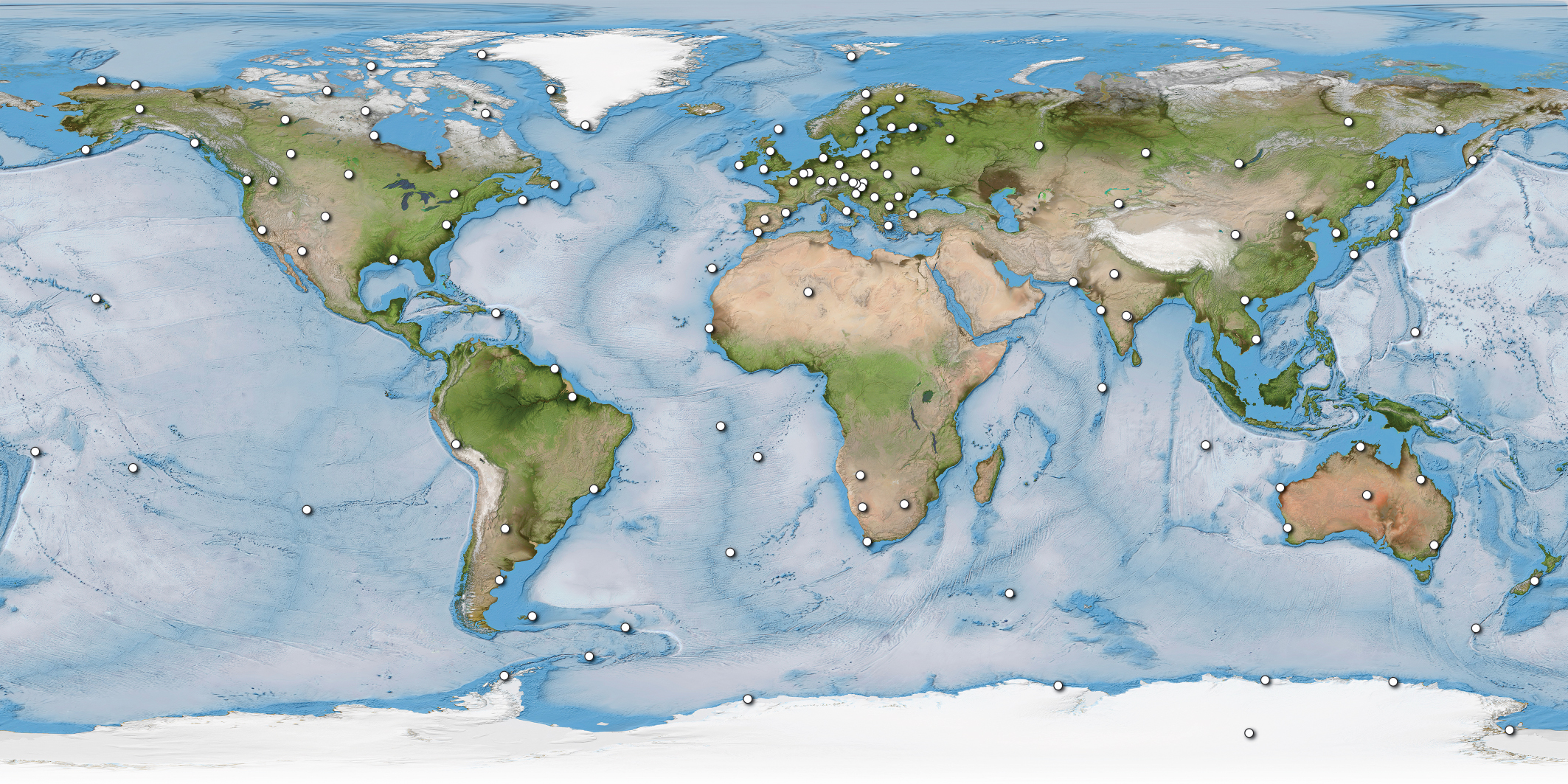
INTERMAGNET supports free data exchange between nations and the creation of geomagnetic data products by scientists and others. It also advises institutes on establishing new magnetic observatories and on upgrading and maintaining existing facilities. The program has now been operating for more than 30 years and, as of 2019, provides access to geomagnetic data from 129 magnetic observatories around the world (Figure 1).
INTERMAGNET continues to adapt to meet the demands of modern user communities in academia, government, and industry.
INTERMAGNET’s roots lie in a pilot data exchange scheme dating to 1987 that used satellite links to facilitate rapid data communication between the U.S. Geological Survey (USGS) and the British Geological Survey (BGS). INTERMAGNET was founded soon after by representatives of USGS, BGS, Institut de Physique du Globe de Paris, and the Geological Survey of Canada. In 1991–1992, the first Geomagnetic Information Node (GIN) allowing data access was established, and the first data CD-ROM was published. This CD-ROM contained what is known in INTERMAGNET as the “definitive” (unchanging, or final) data product of readings reported at a 1-minute sampling interval at 41 magnetic observatories in 1991. Annual releases of definitive data have continued since then through a network of GINs and the INTERMAGNET website, as well as via distributed CD-ROMs, DVDs, USB memory devices, and publication of digital object identifiers (DOIs).
Today, INTERMAGNET continues to adapt to meet the demands of modern user communities in academia, government, and industry. Demand for space weather monitoring data that are nearer to real time and sampled at higher rates than in the past is a major driver for this adaptation, whereas innovations in computing and communications technology are facilitating easier, faster, and more productive data exchange.
Data Types and Delivery Mechanisms Evolve
In its early years, INTERMAGNET’s standard data product was its definitive 1-minute sampled vector data describing the strength and direction of Earth’s magnetic field for given locations. These data are independently checked, validated, and released on an annual basis [Love and Chulliat, 2013]. In 2015 INTERMAGNET ended the annual distribution of definitive data on physical media like discs or USB devices, replacing these with the online INTERMAGNET Reference Data Set (IRDS). The IRDS is updated annually and continues to represent INTERMAGNET’s most complete and quality-checked observatory data set for any year. The IRDS is referenced by year (e.g., IRDS2020), and in addition to containing all definitive data for the given year, it includes data from all previous years along with any corrections that observatories have made to data from previous years.
It takes several years to certify definitive data, the well-vetted data that become part of INTERMAGNET’s permanent record; the most recent definitive data set available is from 2016. In 2013, to address an increasing need for more up-to-date information, INTERMAGNET introduced the Quasi-Definitive Data (QDD) product to provide data more rapidly, using provisional instrument baselines to correct raw data [Peltier and Chulliat, 2010]. The INTERMAGNET specification states that QDD should be available continuously with a lag of no more than 90 days from the time of raw data measurement and that 98% of the differences between measurements in the QDD and the definitive data monthly mean values should be less than 5 nanoteslas (Figure 2). QDD are intended to support modern field-modeling activities, in which fully calibrated satellite data are often promptly available. For example, QDD provide extra constraints for models of secular variation (slow change) of the magnetic field generated by Earth’s core.

One-second data will be of interest in space weather monitoring and mitigation applications, reflecting important timescales over which space weather processes can operate.
In response to developments in instrumentation and the requirements of the research community, INTERMAGNET has set a quality standard for a new 1-second sampled, absolute (i.e., with baseline correction) data product, alongside the standard for 1-minute data. One-second data will be of interest to space weather researchers and in space weather monitoring and mitigation applications, reflecting important timescales over which space weather processes can operate. We have issued an open call to the observatory community to supply 1-second data through INTERMAGNET. The new INTERMAGNET 1-second standard not only demands a faster sampling rate but also sets high demands on noise suppression, absolute level control, and the frequency response of instruments. One-second data from 2014 onward are currently available from 36 INTERMAGNET observatories.
Enhanced Support Services
In recent years, INTERMAGNET has developed and updated its services to streamline and improve the experience of data users. For example, the program has been creating a Web service and comprehensive metadata schema to allow for machine-to-machine access to INTERMAGNET data, according to the definitions laid out in the metadata.
The Creative Commons CC-BY-NC 4.0 license, which is widely understood, machine readable, and available in multiple languages, is now the default license for data available from INTERMAGNET, allowing products to be developed from the basic data while protecting against unauthorized commercial use. (However, because all rights and recognition lie with data providers, not INTERMAGNET itself, some INTERMAGNET contributing institutes may have less restrictive licenses attached to their data.)
INTERMAGNET published its first DOI for the 2013 definitive data DVD and also published DOIs for the 2014 and 2015 data sets. The program will also be publishing all data from 2015 onward with DOIs, which should guarantee for researchers the identical reproducibility of an INTERMAGNET data set.
INTERMAGNET marked the last delivery of definitive data on a physical medium by producing a 25-year celebration USB for the 2015 data, which included all definitive data produced since 1991. From the 2016 definitive data set forward, data will be delivered only online. The DOI system should allow better citation of data, clearer acknowledgment for data providers, better discovery and online access to data, more reuse and reproducibility of data, and a complete set of metadata to uniquely identify data.
INTERMAGNET also develops and hosts software for community use. This growing collection of source code can be found on the INTERMAGNET GitHub and on the INTERMAGNET website and includes routines and toolboxes in Python, Mathematica, Matlab, IDL (Interactive Data Language), and Java for reading and writing in the INTERMAGNET common data format (CDF). For example, there are codes to work with 1-minute definitive data in IAGA-2002 format (established by the International Association of Geomagnetism and Aeronomy), to convert magnetic data among many different formats (e.g., IAGA-2002, WDC format, and several INTERMAGNET formats), and to analyze observatory data. This repository is open for deposition of other source code that could be useful to the geomagnetic science community, and we encourage contributions.
The Future of INTERMAGNET
The past 5 years have seen major changes at INTERMAGNET. As these changes “bed in,” we are already anticipating where the collaboration is headed next.
Many magnetic observatories operate in excellent low electromagnetic noise environments, and some host additional types of geophysical instruments. Among these are permanent geoelectric or telluric field measurement systems (which record electromagnetic fields that diffuse through Earth), which are emerging as a key monitoring need in the space weather community. There is, therefore, a developing idea that INTERMAGNET could help create better international standards for other observatory geophysical measurements and data reporting beyond only geomagnetic data.
We are especially interested in developing partnerships with groups located in parts of the world underrepresented within the network, including Africa, Asia, and South and Central America.
Collaborations between INTERMAGNET and other geophysical networks and agencies will also likely continue to grow, to the benefit of end users, such as the World Meteorological Organization and national and international agencies concerned with space weather. Because data quality and reliability are prime concerns for end users, INTERMAGNET’s longevity, visibility, and innovation maintain the program’s value.
INTERMAGNET encourages institutes and observatories to join the collaboration. We are especially interested in developing partnerships with groups located in parts of the world underrepresented within the network, including Africa, Asia, and South and Central America. INTERMAGNET’s technical manual, which recently received a comprehensive revision, describes how to join the collaboration, as well as the standards for data measurement, processing, formatting, and data submission. (If you are interested, please also contact the authors for more details.)
With a growing geomagnetic monitoring community and with its ongoing innovations, INTERMAGNET is well positioned to continue to play invaluable roles in efforts to understand Earth’s ever-shifting magnetism and in the applications that make use of this understanding.
Acknowledgments
The authors thank David Boteler, Gauthier Hulot, Kristen Lewis, and Chris Turbitt for their critical reading of an early manuscript. We also thank Craig Woodward (British Geological Survey) and Andrew Lewis (Geoscience Australia) for preparing Figures 1 and 2, respectively. INTERMAGNET thanks all institutes and observatory scientists who have contributed to the success of the network over nearly 30 years. Development of INTERMAGNET’s new Web service and comprehensive metadata schema has been partly supported by the European Plate Observing System project (funded by the European Union’s Horizon 2020 research and innovation program under grant agreement 676564). A.W.P.T. is the chair of the Executive Council of INTERMAGNET, and S.M.F. chairs its Operations Committee.
References
Love, J. J., and A. Chulliat (2013), An international network of magnetic observatories, Eos Trans. AGU, 94(42), 373–374, https://doi.org/10.1002/2013EO420001.
Peltier, A., and A. Chulliat (2010), On the feasibility of promptly producing quasi-definitive magnetic observatory data, Earth Planets Space, 62, e5–e8, https://doi.org/10.5047/eps.2010.02.002.
Author Information
Alan W. P. Thomson ([email protected]) and Simon M. Flower, British Geological Survey, Edinburgh, U.K.
Citation:
Thomson, A. W. P., S. M. Flower (2021), Modernizing a global magnetic partnership, Eos, 102, https://doi.org/10.1029/2021EO156569. Published on 31 March 2021.
Text subject to Crown copyright.
Except where otherwise noted, images are subject to copyright. Any reuse without express permission from the copyright owner is prohibited.