
Methane is a potent greenhouse gas, second to carbon dioxide in its overall influence on anthropogenic warming at Earth’s surface, so scientists are keen to keep a close eye on emissions of the gas, both natural and anthropogenic. Thorough records of methane emissions from the landscape allow researchers to better understand processes that contribute emissions, forecast changes in ecosystems, validate models of land–atmosphere exchanges, and estimate regional and continental methane budgets. But collecting such records from a variety of environments over broad spatial and temporal scales is a massive endeavor. Aiding in this task is the National Ecological Observatory Network (NEON).
The National Ecological Observatory Network’s capabilities and data can aid scientists in answering pressing questions about how our environment functions and how it is changing.
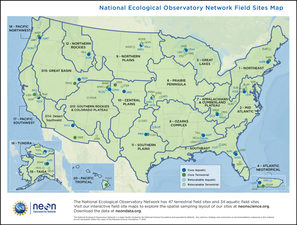
NEON, which comprises numerous sites distributed across the United States and Puerto Rico, will have its newly implemented and community-championed methane concentration data online and openly available by summer 2022. The addition of methane concentration measurements at NEON’s 47 terrestrial sites—spanning the observatory’s 20 designated ecoclimatic domains—will support and facilitate new research investigating greenhouse gas emissions and budgets across the observatory.
Improving understanding of methane emissions across the country is just one example of how NEON’s capabilities and data can aid scientists in answering pressing questions about how our environment functions and how it is changing. Incorporating feedback from the research community is fundamental to NEON’s role in promoting successful science, as is keeping the community updated on developments and pathways for using the observatory. With this in mind, we describe here the available tools and ways to use NEON and invite you to leverage the observatory in your research.
What Is NEON?
NEON is a continental-scale observation facility designed to enable characterization and quantification of complex and rapidly changing ecological processes as well as forecasting of future conditions. The observatory network began construction in 2012 and entered its operational phase in 2019. Today the network includes 47 field sites distributed throughout the major terrestrial ecosystems of the United States and Puerto Rico, plus 34 freshwater aquatic sites located in streams, lakes, and rivers (Figure 1).
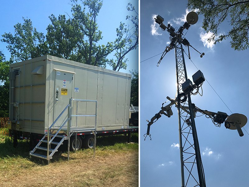
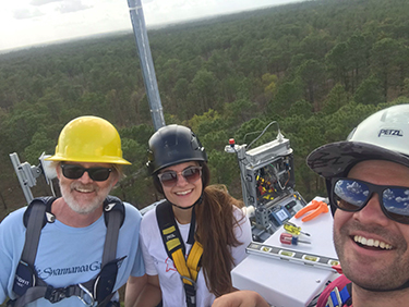
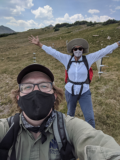
Throughout the network, NEON instruments and staff collect environmental data to characterize trajectories of change in plants, animals, soils, nutrients, freshwater, and the atmosphere. This information composes NEON’s catalog of 181 open-access data products that can be freely downloaded via the NEON Data Portal. Identifying and implementing standardized infrastructure and instrumentation capable of collecting data across a variety of field environments—as well as methodologies that allow for direct comparisons of data among all sites—was a demanding undertaking. For example, installing an array of soil sensors in ecosystems ranging from deserts to tundra required significant engineering flexibility and site-specific expertise. Also challenging were designing and constructing a cyberinfrastructure framework capable of ingesting, processing, formatting, and serving all of NEON’s data and associated metadata in a scalable manner.
NEON also provides an expansive collection of physical specimens and samples that are available to the research community for analysis. Each year, NEON catalogs more than 100,000 individual specimens and samples of soils, vegetation, microbes, insects and other invertebrates, and tissue (e.g., blood, hair, DNA) from fish and other vertebrates into searchable and publicly available archives at the NEON Biorepository Data Portal.
Other archives to which NEON contributes include the Megapit Soil Archive (soils collected and characterized from each NEON site during their initial construction), the NEON Initial Characterization Soils Archive (soils collected during initial operations in partnership with the Natural Resources Conservation Service), and tick samples in the U.S. National Tick Collection at Georgia Southern University.
Leveraging Assignable Assets
The scientific community can use and supplement the observatory’s resources through the Assignable Assets (AA) program. This program allows researchers to leverage the combination of NEON’s robust and diverse standardized observations with the flexibility and creativity of community-led research to advance and innovate in their work (see sidebar).
Resources available via the AA program include specialized equipment and boots-on-the-ground research support at NEON sites. For example, the AA program maintains a fleet of five Mobile Deployment Platforms (MDPs), which are fully instrumented (they largely use the same sensors as NEON’s fixed sites) and can be deployed in environments across the network, provided there is sufficient road access.
Collaborating with NEON
The AA program serves as the entry point to collaborations with NEON, and projects are initiated by filing a formal request through NEON’s website. NEON evaluates not the scientific merit of projects but, rather, the feasibility of completing them while maintaining the efficacy of core NEON measurements.
The AA program is “cost-recoverable,” meaning NEON requires reimbursement for costs (e.g., labor) associated with approved projects. As such, we request that principal investigators (PIs) work with the NEON AA team to ensure the feasibility of their project and to fine-tune expected costs for inclusion in proposals to funding agencies.
The level of coordination and planning needed for proposed AA projects scales with the complexity of the request. A simple request, such as a researcher or educational group asking to arrange a site tour or an introduction to NEON staff at a domain support facility, is typically accommodated within 2 weeks. A moderately complex request could involve, for example, a PI asking to deploy simple temperature monitors (iButtons) and collect soil or sediment samples at a few sites over one or two field seasons. In this case, we would encourage the researcher to engage the AA program at least 6 weeks prior to any proposal deadlines to ensure feasibility, evaluate costs, and, if needed, secure a letter of support to include in funding proposals.
For even more substantial requests involving, for example, deployment of an MDP, addition of specialized sensors to multiple NEON towers, or an extensive multisite and multiyear field sampling campaign, PIs should begin coordination and planning with the AA program several months prior to any proposal submission deadline. This extended timeline is necessary, as PIs must work closely with the observatory to iterate deployment details (e.g., locations, dates, and timelines); facilitation of permits and permissions; schedules; and access to infrastructure, power, and communications.
An MDP allows scientists to incorporate standardized NEON measurement systems—atmospheric, terrestrial, and aquatic—into planned or ongoing research projects at stand-alone sites or sites within other research networks, such as the Long-Term Agroecosystem Research Network, Long Term Ecological Research (LTER) Network, AmeriFlux, or the Critical Zone Collaborative Network. MDPs use data processing algorithms and quality assurance/quality control criteria identical to the instruments at NEON field sites. MDPs thus help tie external research sites into the NEON network and can expand data synthesis, hypothesis testing, and the applicability of research findings to larger regional or even continental scales.
MDPs can also serve as test beds for new technologies. This summer, NEON will deploy an MDP to Ohio State University as part of a proof-of-concept artificial intelligence (AI) and cyberinfrastructure project that will serve as the basis for an adaptive AI system for in-the-field environmental sensing.
NEON also has three Airborne Observation Platforms (AOPs), each comprising a sophisticated remote sensing package deployed on a Twin Otter aircraft. These payloads include a high-resolution digital camera; lidar instrumentation to provide 3D structural information about the landscape; and an imaging spectrometer to allow identification of plant species and communities, map vegetation health, and provide data on canopy chemical constituents.
For example, in work supported by the National Science Foundation (NSF) in conjunction with the University of Colorado (CU) Boulder, an AOP was used to map postfire burns at several sites where fire emissions had been previously observed during the CU Boulder Biomass Burning Fluxes of Trace Gases and Aerosols campaign. This research aimed to relate wildfire emission characteristics to ecosystem parameters to improve the prediction of environmental and human health impacts from wildfires. AOP data provided information on total area burned and allowed partners from the U.S. Forest Service to calculate biomass lost.
Through the AA program, scientists can request an MDP or flight time with the AOP, request samples, coordinate visits to NEON field sites to conduct their own sampling campaigns, and deploy their own instruments to existing NEON infrastructure [e.g., Kramer and Chadwick, 2018; Chlus et al., 2020; Dangal and Sanderman, 2020; Hall et al., 2020; Zhang et al., 2021]. NEON’s field science staff and 18 domain support facilities are additional resources and can help principal investigators (PIs) with logistics, sample collection and processing, and sensor deployment [e.g., Blair et al., 2020; Chadwick et al., 2020; Chaudhary et al., 2020; Heckman et al., 2020; Seyednasrollah et al., 2021].
Targets of Opportunity
Events like floods, fires, hurricanes, and earthquakes, or perturbations such as dramatic predator population shifts, can drive rapid ecological change and often present time-sensitive “targets of opportunity” for research [Whitman et al., 2021]. These disturbances often occur without warning and outside the boundaries of NEON sites. NEON’s mobile sensing systems offer the capacity to investigate targets of opportunity, and the AA program is equipped to expedite review of time-sensitive requests to help PIs take advantage of these fleeting research opportunities.In 2016, for example, the Chimney Tops 2 Fire burned 4,167 hectares of Great Smoky Mountains National Park, including the NEON site contained within the park’s boundaries. Leveraging rapid response funding from NSF, researchers worked with the NEON AA program to access the site immediately following the fire and collect samples for a study of pyrogenic carbon mobility [Matosziuk et al., 2020].
Evolving to Meet Community Needs
As NEON evolves over its planned 30-year life span, the observatory is working to increase the discoverability and accessibility of its core data products and infrastructure, while also building new inroads for assimilating and responding to community feedback. Sustaining core functionality while evaluating evolving scientific priorities, new methodologies, and advances in instrumentation and computing will be a continual challenge over the life span of the observatory. Creating channels for bidirectional communication with the community is, and will continue to be, critical to NEON’s ability to balance its resources with community priorities and shifting technologies, and we look forward to growing these conversations and collaborations over time.
To that end, NEON consults with a diverse set of 180 scientists and educators from across academia, government, and industry who make up more than 20 technical working groups (TWGs) and advise NEON on wide-ranging technical issues. TWG recommendations that involve changes to the scope or science requirements of NEON, or significant potential enhancements of it, are vetted with help from a community-based advisory body. These collaborative pathways allow for communication among NSF, NEON, and the scientific community and enable appropriate evolution of NEON to maintain its value in facilitating forefront science and education.
In addition, frequent workshops, presentations, facility tours, and other events—whether instigated within NEON or by members of the external research community—provide opportunities to optimize NEON. For example, over 2 days in 2019, the first NEON Science Summit, organized by CU Boulder, brought together 170 participants to explore major questions that can be addressed at continental scales using NEON data. NEON scientists and other staff provided guidance on data products and captured community feedback to enhance the delivery of NEON data, including, for example, through the creation of concise user guides for NEON data products.
With exciting developments on the horizon such as the NSF Center for Advancement and Synthesis of Open Environmental Data and Sciences, which will coordinate open data assets at NEON, LTER, and other programs to speed the research discovery process, we anticipate many new ways that NEON’s data and samples will be used across the community. We encourage researchers to explore opportunities to become involved with NEON, engage with our staff at meetings, and, most important, provide feedback to help us best meet the research community’s evolving needs.
Acknowledgments
NEON is sponsored by NSF and operated under cooperative agreement by Battelle. This material is based in part upon work supported by NSF through the NEON program. ORCID numbers for the authors are 0000-0002-1962-3561 (SanClements) and 0000-0002-8455-3213 (Mabee).
References
Blair, J., et al. (2020), Robust and simplified machine learning identification of pitfall trap‐collected ground beetles at the continental scale, Ecol. Evol., 10(23), 13,143–13,153, https://doi.org/10.1002/ece3.6905.
Chadwick, K. D., et al. (2020), Integrating airborne remote sensing and field campaigns for ecology and Earth system science, Methods Ecol. Evol., 11(11), 1,492–1,508, https://doi.org/10.1111/2041-210X.13463.
Chaudhary, V. B., et al. (2020), Trait‐based aerial dispersal of arbuscular mycorrhizal fungi, New Phytol., 228(1), 238–252, https://doi.org/10.1111/nph.16667.
Chlus, A., E. L. Kruger, and P. A. Townsend (2020), Mapping three-dimensional variation in leaf mass per area with imaging spectroscopy and lidar in a temperate broadleaf forest, Remote Sens. Environ., 250, 112043, https://doi.org/10.1016/j.rse.2020.112043.
Dangal, S. R. S., and J. Sanderman (2020), Is standardization necessary for sharing of a large mid-infrared soil spectral library?, Sensors, 20(23), 6729, https://doi.org/10.3390/s20236729.
Hall, S. J., et al. (2020), Molecular trade-offs in soil organic carbon composition at continental scale, Nat. Geosci., 13(10), 687–692, https://doi.org/10.1038/s41561-020-0634-x.
Heckman, K. A., et al. (2020), Divergent controls on carbon concentration and persistence between forests and grasslands of the conterminous US, Biogeochemistry, https://doi.org/10.1007/s10533-020-00725-z.
Kramer, M. G., and O. A. Chadwick (2018), Climate-driven thresholds in reactive mineral retention of soil carbon at the global scale, Nat. Clim. Change, 8(12), 1,104–1,108, https://doi.org/10.1038/s41558-018-0341-4.
Matosziuk, L. M., et al. (2020), Short-term effects of recent fire on the production and translocation of pyrogenic carbon in Great Smoky Mountains National Park, Frontiers For. Global Change, 3, 6 pp., https://doi.org/10.3389/ffgc.2020.00006.
Seyednasrollah, B., et al. (2021), Seasonal variation in the canopy color of temperate evergreen conifer forests, New Phytol., 229(5), 2,586–2,600, https://doi.org/10.1111/nph.17046.
Whitman, T., et al. (2021), Microbial community shifts reflect losses of native soil carbon with pyrogenic and fresh organic matter additions and are greatest in low-carbon soils, Appl. Environ. Microbiol., 87(8), e02555-20, https://doi.org/10.1128/AEM.02555-20.
Zhang, Y., A. E. Hartemink, and J. Huang (2021), Spectral signatures of soil horizons and soil orders: An exploratory study of 270 soil profiles, Geoderma, 389, 114961, https://doi.org/10.1016/j.geoderma.2021.114961.
Author Information
Michael SanClements ([email protected]) and Paula Mabee, National Ecological Observatory Network, Battelle, Boulder, Colo.
Citation:
SanClements, M., P. Mabee (2021), NEON lights a path for sustained ecological observations, Eos, 102, https://doi.org/10.1029/2021EO160240. Published on 28 June 2021.
Text © 2021. The authors. CC BY-NC-ND 3.0
Except where otherwise noted, images are subject to copyright. Any reuse without express permission from the copyright owner is prohibited.