
Soaring 4750 meters above the Kamchatka Peninsula near the western shore of the Bering Sea, the Klyuchevskoy volcano is one of the most active in the world. Many international flights connecting North America and Asia fly over the peninsula, where a group of active volcanoes, including Klyuchevskoy, occasionally fills the air with ash and dust. What drives the unusually high volcanic activity here? Do these volcanoes feed from the same large pool of magma?
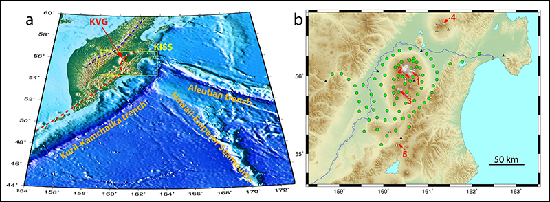
The Klyuchevskoy volcanic group (KVG), a part of the Kuril-Kamchatka volcanic belt, is located in a subduction zone where the Pacific oceanic plate plunges beneath the tectonic plate that carries the peninsula (Figure 1a). The strength and variety of volcanic activity in the region make it a natural laboratory to study where magma sits and how it moves in a subduction zone.
Previous surveys have been limited to the area around Klyuchevskoy. That changed in 2015–2016, when an international collaboration conducted the first geophysical survey of the entire KVG. The effort was named the Klyuchevskoy Investigation—Seismic Structure of an Extraordinary Volcanic System (KISS) experiment.
Instruments recorded the full sequence of events that preceded the most recent eruption of Klyuchevskoy last April.
Data from KISS’s instrument network offer an unprecedented look at one of Earth’s most active volcanic regions and could reveal whether the underlying magma reservoirs are connected by one large volcanic supercomplex. The instruments also provided a real-time record of an unfolding eruption: They recorded the full sequence of events that preceded the most recent eruption of Klyuchevskoy last April.
The Klyuchevskoy Volcanic Group
Over the past 10,000 years, the Klyuchevskoy volcano has produced an average of 1 cubic meter of erupted rocks every second [Fedotov et al., 1987]. This eruption rate is much higher than that of most volcanoes associated with subduction and is comparable to the growth of the Hawaiian volcanic chain, often considered one of the most vigorous volcanic systems of modern Earth.
Besides Klyuchevskoy, the KVG contains 12 other large volcanoes. Two of them, Bezymianny and Tolbachik, have been very active in the past few decades. Two other active volcanoes, Shiveluch and Kizimen, are located only 60 kilometers north and south, respectively, of KVG (Figure 1b).
A whole spectrum of eruptive styles is present in the KVG, ranging from steady Hawaiian-type eruptions, as seen during the two most recent eruptions of Tolbachik, to the strongly explosive eruptions of Bezymianny in 1956, which were among the world’s largest eruptions in the 20th century. (The name “Bezymianny” means “unnamed” in Russian: Until the 1956 eruption, the volcano was considered to be extinct, so no one bothered to give it a name.)
The region’s exceptional volcanic activity is related to the unique tectonic setting of the KVG, located at the sharp corner between the Kuril-Kamchatka and Aleutian trenches. This corner is where the Hawaiian-Emperor seamount chain, the underwater mountain range that stretches down to Hawaii, is subducted, and the KVG is perched above the edge of the subducted slab (Figure 1a).
Geodynamic models that attempt to explain the voluminous volcanism in the KVG are complex and include many factors. They include the release of fluids from the thick, highly hydrated Hawaiian-Emperor crust [Dorendorf et al., 2000], the mantle flow around the corner of the Pacific Plate [Yogodzinski et al., 2001], and the recent detachment of a portion of the slab due to a recent eastward jump of the subduction zone beneath Kamchatka [Levin et al., 2002]. The large variability of lavas and eruption styles reflects the complexity of the feeding system of magma sources and reservoirs in both the upper mantle and the crust.
A Unique Natural Laboratory
Because of its strong and variable activity, the KVG is a unique natural laboratory for studying volcanism in a subduction zone. Understanding how this zone functions requires detailed knowledge about the configuration of the subducted oceanic plates and about the distribution of magma conduits and reservoirs within the mantle wedge and the crust. A particularly important question is whether the individual KVG volcanoes are fed from independent magma sources or form a single interconnected magmatic supersystem.
Gathering information about the deep KVG structure requires the use of geophysical methods. Past seismological studies [Koulakov et al., 2011] have revealed possible pathways of melts ascending from the subducting slab and a multilevel system of magma reservoirs in the crust. However, the structures that these studies illuminated are mainly restricted to a few tens of kilometers surrounding the Klyuchevskoy volcano, where most existing permanent seismic stations are located (Figure 1b). A full understanding of the behavior of the KVG magmatic system requires an investigation of subsurface structures at a much larger scale.
The KISS Project
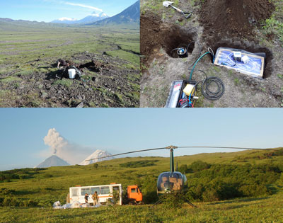
To undertake such a large-scale seismological investigation of the KVG, we formed a consortium of institutions from Russia, France, and Germany and designed the KISS experiment. We operated a temporary network of 83 seismographs between August 2015 and July 2016.
The experiment took place in difficult terrain; helicopters and off-road trucks were needed to transport the equipment and field crews to the installation sites (Figure 2). An eruption-triggered mudflow destroyed one site, and a few others were wrecked by bears. Despite the harsh environment, the team recovered data from 77 instruments (Figure 1b).
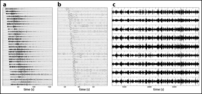
Initial inspection of seismograms indicates that the network successfully recorded many tectonic and volcanic earthquakes and volcanic tremors (Figure 3). The collected data set, combined with records from permanent seismic stations, will be used to study various types of earthquakes associated with the volcanic and magmatic activity and to image the crust and upper mantle with multiscale seismic tomography.
These results will help us understand why exceptionally large amounts of melts are generated in the upper mantle at the Kamchatka-Aleutian subduction corner and how these magmas are transformed during the ascent through the crust, producing the vigorous and very variable volcanism we see at the surface.
Monitoring the KVG for Hazardous Eruptions
Volcanic eruptions regularly affect a few small settlements located near the KVG, and they pose a significant threat to aviation because many international flights that connect North America and Asia pass over Kamchatka. Large explosive eruptions such as those of Bezymianny in 1956 and Shiveluch in 1964, when about 1 cubic kilometer of erupted material was ejected, might be particularly dangerous.
Moreover, Kamchatka has a well-established record of even larger caldera-forming eruptions in the Holocene [Braitseva et al., 1995], with the largest of them forcibly ejecting about 150 cubic kilometers of rock fragments (tephra).
Considering that at present more than half of Kamchatka volcanic magmas are generated below the KVG, we cannot ignore the possibility of a future extreme explosive event in this region. We expect that the results of the KISS experiment will help us to evaluate such extreme event scenarios by improving our knowledge of the size of the KVG crustal magmatic reservoirs, along with the volume of potentially explosive magmas that they might contain.
When the Klyuchevskoy volcano rumbled back to life and erupted in April 2016, the KISS network recorded the full sequence of reactivation leading up to the eruption. We will use this data set to improve our knowledge of how the rise of magma and the preeruptive buildup of pressure are expressed in the continuous seismic signals. The data will also help refine the routine monitoring of the KVG and other nearby volcanoes performed by the Kamchatka Branch of Russia’s Geophysical Survey and by the Kamchatka Volcanic Eruption Response Team, which is operated by the Institute of Volcanology and Seismology.
Acknowledgments
The KISS experiment was supported by the Russian Science Foundation (grant 14-47-00002), the French project “Labex UnivEarth,” and the Université Sorbonne Paris Cité project “VolcanoDynamics.” Sixty seismographs were provided by Geophysical Instrument Pool Potsdam (GIPP) from the Helmholtz Center Potsdam-GFZ German Research Centre for Geosciences, and 23 were provided by the partner institutions from the Russian Academy of Sciences: the Institute of Volcanology and Seismology, the Trofimuk Institute of Petroleum Geology and Geophysics, and the Kamchatka Branch of the Geophysical Survey. KISS data are stored in the GFZ Seismological Data Archive operated by the GEOFON program and will be openly available after a 3-year embargo period. We are grateful to Sergey Abramenkov, Benjamin Heit, Pavel Kuznetsov, Ekaterina Kukarina, Roman Kulakov, Alexey Kotlyarov, Valeriy Gladkov, Petr Voropaev, Dmitry Droznin, Sergey Senyukov, and Vitaly Bliznetsov, who participated in the fieldwork. Special thanks are owed to Sergey Chirkov for providing field photographs and to the truck driver, Igor Uteshev, as well as to the helicopter pilot, Gennady Kroshkin.
References
Braitseva, O. A., et al. (1995), The ages of calderas, large explosive craters and active volcanoes in the Kuril–Kamchatka region, Bull. Volcanol., 57, 383–402.
Dorendorf, F., U. Wiechert, and G. Wörner (2000), Hydrated sub-arc mantle: A source for the Kluchevskoy volcano, Kamchatka/Russia, Earth Planet. Sci. Lett., 175, 69–86, https://doi.org/10.1016/S0012-821X(99)00288-5.
Fedotov, S. A., A. P. Khrenov, and N. A. Jarinov (1987), Klyuchevskoy volcano, its activity in 1932–1986 and possible development [in Russian], Volcanol. Seismol., 4, 3–16. [Volcanol. Seismol., Engl. transl., 9, 501–521, 1990.]
Koulakov, I., et al. (2011), Feeding volcanoes of the Kluchevskoy group from the results of local earthquake tomography, Geophys. Res. Lett., 38, L09305, https://doi.org/10.1029/2011GL046957.
Levin, V., et al. (2002), Seismic evidence for catastrophic slab loss beneath Kamchatka, Nature, 418, 763–767, https://doi.org/10.1038/nature00973.
Yogodzinski, G. M., et al. (2001), Geochemical evidence for the melting of subducting oceanic lithosphere at plate edges, Nature, 409, 500–504, https://doi.org/10.1038/35054039.
Author Information
Nikolai M. Shapiro (email: [email protected]), Institut de Physique du Globe de Paris, France; Christoph Sens-Schönfelder, Birger G. Lühr, and Michael Weber, GFZ German Research Centre for Geosciences, Potsdam, Germany; Ilyas Abkadyrov and Evegeny I. Gordeev, Institute of Volcanology and Seismology, Far East Branch of Russian Academy of Sciences, Petropavlovsk-Kamchatsky, Russia; Ivan Koulakov and Andrey Jakovlev, Trofimuk Institute of Petroleum Geology and Geophysics, Siberian Branch of Russian Academy of Sciences and Novosibirsk State University, Novosibirsk, Russia; and Yulia A. Kugaenko and Vadim A. Saltykov, Kamchatka Branch of the Geophysical Survey, Russian Academy of Sciences, Petropavlovsk-Kamchatsky, Russia
Citation:
Shapiro, N. M.,Sens-Schönfelder, C.,Lühr, B. G.,Weber, M.,Abkadyrov, I.,Gordeev, E. I.,Koulakov, I.,Jakovlev, A.,Kugaenko, Y. A., and Saltykov, V. A. (2017), Understanding Kamchatka’s extraordinary volcano cluster, Eos, 98, https://doi.org/10.1029/2017EO071351. Published on 01 May 2017.
Text © 2017. The authors. CC BY 3.0
Except where otherwise noted, images are subject to copyright. Any reuse without express permission from the copyright owner is prohibited.