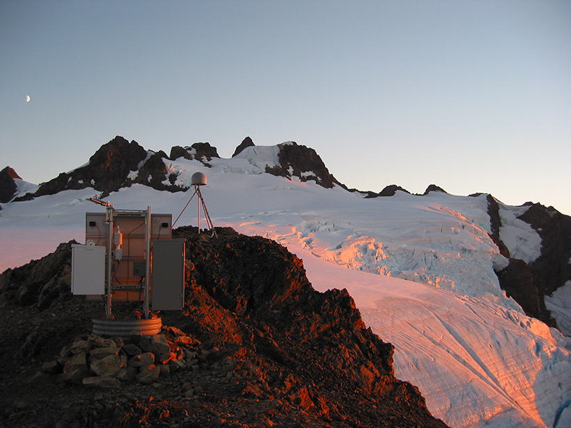
• About
  • Special Reports
  • Topics
    • Climate
    • Earth Science
    • Oceans
    • Space & Planets
    • Health & Ecosystems
    • Culture & Policy
    • Education & Careers
    • Opinions
  • Projects
    • Postcards From the Field
    • ENGAGE
    • Editors’ Highlights
    • Editors’ Vox
    • Eos en Español
    • Eos 简体中文版
    • Print Archive: 2015–2025
  • Policy Tracker
  • Blogs
    • Research & Developments
    • The Landslide Blog
  • Newsletter
  • Submit to Eos
  • AGU.org
  • Career Center
  • Join AGU
  • Give to AGU
  • About
  • Special Reports
  • Topics
    • Climate
    • Earth Science
    • Oceans
    • Space & Planets
    • Health & Ecosystems
    • Culture & Policy
    • Education & Careers
    • Opinions
  • Projects
    • Postcards From the Field
    • ENGAGE
    • Editors’ Highlights
    • Editors’ Vox
    • Eos en Español
    • Eos 简体中文版
    • Print Archive: 2015–2025
  • Policy Tracker
  • Blogs
    • Research & Developments
    • The Landslide Blog
  • Newsletter
  • Submit to Eos
Skip to content
  • AGU.org
  • Career Center
  • Join AGU
  • Give to AGU
Eos

Eos

Science News by AGU

Support Eos
Sign Up for Newsletter
  • About
  • Special Reports
  • Topics
    • Climate
    • Earth Science
    • Oceans
    • Space & Planets
    • Health & Ecosystems
    • Culture & Policy
    • Education & Careers
    • Opinions
  • Projects
    • Postcards From the Field
    • ENGAGE
    • Editors’ Highlights
    • Editors’ Vox
    • Eos en Español
    • Eos 简体中文版
    • Print Archive: 2015–2025
  • Policy Tracker
  • Blogs
    • Research & Developments
    • The Landslide Blog
  • Newsletter
  • Submit to Eos

cool tools

A collapsed portion of freeway after the Loma Prieta earthquake
Posted inNews

California Launches Nation’s First Earthquake Early Warning System

Jenessa Duncombe, Staff Writer by Jenessa Duncombe 24 October 20196 October 2021

The country’s first publicly available, statewide warning system could give California residents crucial seconds to duck and cover before a quake.

Screenshot of the control panel of the CAT-HI tool
Posted inEditors' Highlights

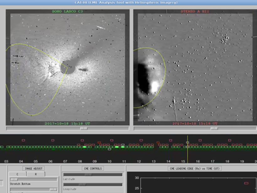
Looking Away from the Sun: Improved Tracking of Solar Storms

by Michael A. Hapgood 17 September 201913 October 2021

A new tool for tracking coronal mass ejections away from the Sun opens a path toward more accurate warnings for operators who have to cope with adverse space weather.

Black-and-white illustration of Captain Ahab on the deck of a ship
Posted inGeoFIZZ

Was Ahab Truly “Lord of the Level Loadstone”?

by D. Dorritie 4 September 201930 September 2021

Herman Melville’s bicentennial provides a good excuse to examine how well the Pequod’s monomaniacal mariner knew his geomagnetic magic.

Science buildings and living quarters on Fletcher’s Ice Island in 1967
Posted inNews

Scientists Rescue Historical Data Taken on Floating Ice Island

Jenessa Duncombe, Staff Writer by Jenessa Duncombe 27 August 20198 November 2021

A never-before-published data set from the Cold War could help scientists unravel the mysterious western Arctic Ocean.

Map of continental USA showing horizontal distribution of the mean of the logarithmic eddy dissipation rate in the troposphere
Posted inEditors' Highlights

Radiosondes Measure Atmospheric Turbulence Over North America

by William J. Randel 16 August 201925 July 2022

Analyses of high-resolution radiosonde balloon measurements have provided a novel climatology of atmospheric turbulence parameters in the troposphere and lower stratosphere.

A vertical-lift bridge spanning a river
Posted inNews

This Bridge Monitors the Environment and Harnesses Tidal Energy

Rachel Crowell, Science Writer by Rachel Crowell 7 August 20199 May 2022

The “smart” Memorial Bridge spanning the Piscataqua is outfitted with a tidal turbine and more than 40 sensors.

Photo of a man in a lab coat holding a soil core
Posted inNews

New Tool Reveals That Soils Are Teeming with Active Microbes

Sarah Derouin, Science Writer by Sarah Derouin 6 August 201931 January 2023

BONCAT, a new type of amino acid tagging, highlights and categorizes active soil microbes in situ.

Plots of average wave electric field power spectral densities on the nightside
Posted inEditors' Highlights

Human-made Emissions Modify Electron Space Environment

by Viviane Pierrard 2 August 20198 August 2022

Very Low Frequency transmitters used for communications with submarines modify the dynamics of energetic electrons in the inner radiation belt and the slot region.

Wispy cirrus clouds hover high above an open farm field.
Posted inResearch Spotlights

A Better Way to Measure Cloud Composition

by E. Underwood 30 July 201925 July 2022

An enhanced satellite remote sensing suite accurately measures ice particles, temperature, and water vapor.

A river and snowy mountains on a sunny day
Posted inNews

Bringing Climate Projections Down to Size for Water Managers

Kimberly M. S. Cartier, News Writing and Production Intern for Eos.org by Kimberly M. S. Cartier 26 July 20193 April 2023

Hydrologists are creating watershed-scale projections for water resources managers and tools that managers can use to plan for the effects of climate change.

Posts pagination

Newer posts 1 … 23 24 25 26 27 … 37 Older posts
Over a dark blue-green square appear the words Special Report: The State of the Science 1 Year On.

Features from AGU Publications

Research Spotlights

How Internal Waves Transport Energy Thousands of Miles Across the Ocean

26 March 202626 March 2026
Editors' Highlights

What’s Under the Water Matters

27 March 202626 March 2026
Editors' Vox

The Future of Earth’s Future

24 March 202624 March 2026
Eos logo at left; AGU logo at right

About Eos
ENGAGE
Awards
Contact

Advertise
Submit
Career Center
Sitemap

© 2026 American Geophysical Union. All rights reserved Powered by Newspack