
Considering Earth’s interacting systems could pull the planet back into a stable operating space.
Earth science

Posted inNews
Hurricane Harvey Filled Houston with Sediment
The storm’s record-setting rains moved an equally impressive amount of sediment and elevated the risk and expense of absorbing all that muck.

Posted inEditors' Highlights
Illuminating the Complex Structural Fabric Beneath the European Alps
A new study investigates the dynamics of the complex continental collision that formed the European Alps and reveals how structural alignments change with depth.

Posted inNews
Plants Worldwide Reach a Stomata Stalemate
Research unveiled a surprising plateau in plants’ ability to absorb carbon through stomata, which could mean more carbon left in the atmosphere.

Posted inEditors' Highlights
Earthquakes Have Preparatory Stage Years Before Rupture
Tidally induced seismicity increased locally before the 2019 Ridgecrest earthquake, suggesting that fault sensitivity to stress increases in the years immediately before large earthquakes.
Posted inEditors' Highlights
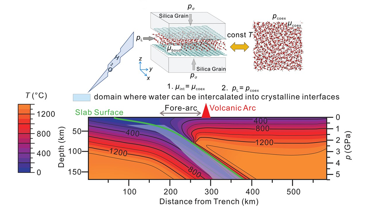
Fluid Release from Subducted Slabs Without Percolation Flow
A new study demonstrates the absorption mechanism of H2O release out of subducting slabs, making the previous hypothesis of dehydration embrittlement unnecessary.

Posted inNews
Low-Tech, Energy-Free Tool Collects and Cleans Fog Water
A new fog harvester could benefit communities that lack access to clean freshwater.

Posted inNews
Flowing Crust Pushes Faults on Their Backs
Puzzlingly shallow faults in western Türkiye are likely getting a boost from below.

Posted inResearch Spotlights
Radar Tracks Unfortunate Creatures Trapped in Tropical Cyclones
Cyclones can sweep up birds and insects and transport them great distances.

Posted inENGAGE, News
Protein Powder Makes Ice Crystals Flower
Dust from Alaska is particularly effective at forming ice crystals because it contains biological components, researchers believe. The finding has implications for cloud physics and our planet’s climate.