• About
  • Sections
  • Topics
    • Climate
    • Earth Science
    • Oceans
    • Space & Planets
    • Health & Ecosystems
    • Culture & Policy
    • Education & Careers
    • Opinions
  • Projects
    • ENGAGE
    • Editors’ Highlights
    • Editors’ Vox
    • Eos en Español
    • Eos 简体中文版
    • Print Archive
  • Blogs
    • Research & Developments
    • The Landslide Blog
  • Newsletter
  • Submit to Eos
  • AGU.org
  • Career Center
  • Join AGU
  • Give to AGU
  • About
  • Sections
  • Topics
    • Climate
    • Earth Science
    • Oceans
    • Space & Planets
    • Health & Ecosystems
    • Culture & Policy
    • Education & Careers
    • Opinions
  • Projects
    • ENGAGE
    • Editors’ Highlights
    • Editors’ Vox
    • Eos en Español
    • Eos 简体中文版
    • Print Archive
  • Blogs
    • Research & Developments
    • The Landslide Blog
  • Newsletter
  • Submit to Eos
Skip to content
  • AGU.org
  • Career Center
  • Join AGU
  • Give to AGU
Eos

Eos

Science News by AGU

Support Eos
Sign Up for Newsletter
  • About
  • Sections
  • Topics
    • Climate
    • Earth Science
    • Oceans
    • Space & Planets
    • Health & Ecosystems
    • Culture & Policy
    • Education & Careers
    • Opinions
  • Projects
    • ENGAGE
    • Editors’ Highlights
    • Editors’ Vox
    • Eos en Español
    • Eos 简体中文版
    • Print Archive
  • Blogs
    • Research & Developments
    • The Landslide Blog
  • Newsletter
  • Submit to Eos

El Salvador

Satellite image of a city between a volcano and a lake
Posted inNews

Eruption in El Salvador Was One of the Holocene’s Largest

Katherine Kornei, Science Writer by Katherine Kornei 5 June 201922 August 2023

Roughly 1,500 years ago, the Tierra Blanca Joven eruption blanketed Central America in ash and likely displaced Maya settlements, new research shows.

After a 2012 landslide in Finca Loma Linda, Guatemala, 46 people were forced to evacuate to an emergency shelter.
Posted inScience Updates

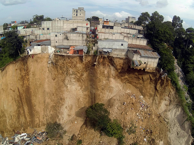
An Early Warning System for Landslide Danger

by A. J. Posner and K. P. Georgakakos 3 November 20166 January 2023

Advances in satellite imaging, mapping, and rainfall estimations have made it possible to implement a regional real-time assessment of landslide hazard threats across Central America.

A view of a Washington, D.C., skyline from the Potomac River at night. The Lincoln Memorial (at left) and the Washington Monument (at right) are lit against a purple sky. Over the water of the Potomac appear the text “#AGU24 coverage from Eos.”

Features from AGU Publications

Research Spotlights

How Greenland’s Glacial Troughs Influence Ocean Circulation

29 May 202529 May 2025
Editors' Highlights

Seasonal Iron Cycle and Production in the Subantarctic Southern Ocean

29 May 202529 May 2025
Editors' Vox

Keeping Soil Healthy: Why It Matters and How Science Can Help

29 May 202529 May 2025
Eos logo at left; AGU logo at right

About Eos
ENGAGE
Awards
Contact

Advertise
Submit
Career Center
Sitemap

© 2025 American Geophysical Union. All rights reserved Powered by Newspack