• About
  • Special Reports
  • Topics
    • Climate
    • Earth Science
    • Oceans
    • Space & Planets
    • Health & Ecosystems
    • Culture & Policy
    • Education & Careers
    • Opinions
  • Projects
    • Postcards From the Field
    • ENGAGE
    • Editors’ Highlights
    • Editors’ Vox
    • Eos en Español
    • Eos 简体中文版
    • Print Archive: 2015–2025
  • Policy Tracker
  • Blogs
    • Research & Developments
    • The Landslide Blog
  • Newsletter
  • Submit to Eos
  • AGU.org
  • Career Center
  • Join AGU
  • Give to AGU
  • About
  • Special Reports
  • Topics
    • Climate
    • Earth Science
    • Oceans
    • Space & Planets
    • Health & Ecosystems
    • Culture & Policy
    • Education & Careers
    • Opinions
  • Projects
    • Postcards From the Field
    • ENGAGE
    • Editors’ Highlights
    • Editors’ Vox
    • Eos en Español
    • Eos 简体中文版
    • Print Archive: 2015–2025
  • Policy Tracker
  • Blogs
    • Research & Developments
    • The Landslide Blog
  • Newsletter
  • Submit to Eos
Skip to content
  • AGU.org
  • Career Center
  • Join AGU
  • Give to AGU
Eos

Eos

Science News by AGU

Support Eos
Sign Up for Newsletter
  • About
  • Special Reports
  • Topics
    • Climate
    • Earth Science
    • Oceans
    • Space & Planets
    • Health & Ecosystems
    • Culture & Policy
    • Education & Careers
    • Opinions
  • Projects
    • Postcards From the Field
    • ENGAGE
    • Editors’ Highlights
    • Editors’ Vox
    • Eos en Español
    • Eos 简体中文版
    • Print Archive: 2015–2025
  • Policy Tracker
  • Blogs
    • Research & Developments
    • The Landslide Blog
  • Newsletter
  • Submit to Eos

freshwater

Graph showing range of water levels in the Great Lakes and the potential benefit from risk management strategies including insurance and dredging
Posted inEditors' Highlights

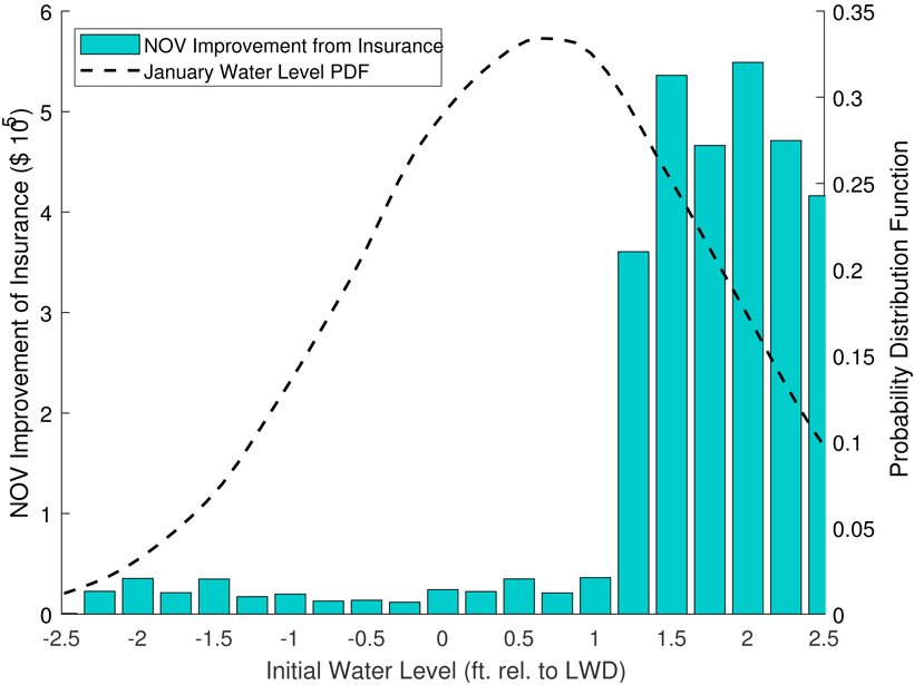
New Analysis Helps Manage Risks to Shipping in the Great Lakes

by Jim Hall 11 May 202018 October 2022

Modeling of mysteriously fluctuating water levels in the Great Lakes has helped to optimize the prices of shipping insurance contracts along with investments in dredging navigation channels.

The Tigris River near Diyarbakir, Turkey
Posted inResearch Spotlights

Shaping Water Management with Planetary Boundaries

Aaron Sidder, freelance science writer by Aaron Sidder 20 April 202018 April 2023

A new study uses the planetary boundaries concept to formulate an approach to water management that considers both global and local limits to water cycle modifications.

Aerial view of a scene of the Alps near the border of France and Italy showing snowy mountains and lakes
Posted inResearch Spotlights

A Graceful Way to Study Daily Water Storage on Land

by David Shultz 17 April 202029 September 2021

A new analysis technique could help scientists improve the temporal resolution of satellite gravity data and see trends in terrestrial water storage and movement in near real time.

An aerial view of an agricultural landscape
Posted inResearch Spotlights

Mapping Nutrient Inputs in the Great Lakes Basin

Aaron Sidder, freelance science writer by Aaron Sidder 25 March 202024 February 2023

A new tool links nitrogen and phosphorus applications to land use classifications to better understand where and how much of the nutrients enter watersheds in the U.S. Great Lakes Basin.

Figure showing whether assemblages containing quartz, talc, and carbonate can be produced from an oxidized hydrous rocky core under plausible conditions for Enceladus.
Posted inEditors' Highlights

The Freshest Mineral Water in the Solar System

by A. Dombard 24 March 202022 December 2021

The water-rich plumes erupting from Saturn’s moon Enceladus show the chemical signs of water-rock interactions deep within the moon, further implicating Enceladus as a potential habitat for life.

Posted inNews

Rastreando Los Misteriosos Manantiales Del Gran Cañón

Mary Caperton Morton, Science Writer by Mary Caperton Morton 20 March 202016 July 2025

Mejorar los modelos ayudará a proteger una fuente crucial de agua potable para ambos bordes del Parque Nacional del Gran Cañón.

A pipeline stretches across a flowing river in a small canyon.
Posted inNews

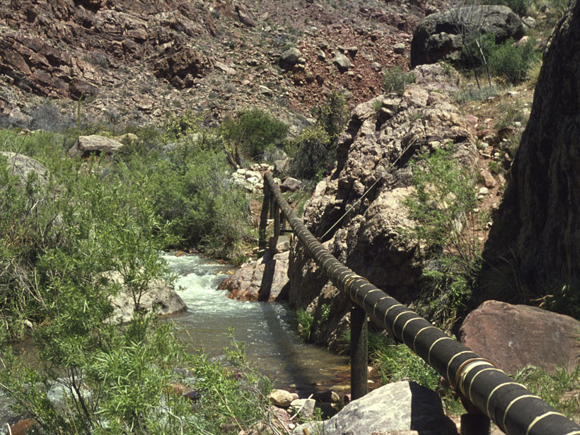
Tracking the Grand Canyon’s Mysterious Springs

Mary Caperton Morton, Science Writer by Mary Caperton Morton 24 February 202016 July 2025

Improved modeling will help protect a crucial drinking water source for both rims of Grand Canyon National Park.

A stream running through a forest
Posted inNews

The Shape of Watersheds

Hannah Thomasy, Science Writer by Hannah Thomasy 21 January 20201 March 2023

Streams in flatter watersheds have carbon cycles more sensitive to temperature increases.

Four charts showing optimal habitats in the floodplain for different stream insects.
Posted inEditors' Highlights

Hydropower and Bugs

by E. Wohl 16 December 201928 February 2023

Alpine hydropower plants commonly flush sediment that accumulates at intakes, but the associated rapid rise in discharge, turbidity, and streambed instability put aquatic insects at risk.

Pools of bright blue water amid ice
Posted inNews

Freshwater Pools Show Antarctica Is More Vulnerable Than We Thought

Kimberly M. S. Cartier, News Writing and Production Intern for Eos.org by Kimberly M. S. Cartier 4 October 201927 March 2023

East Antarctica’s lakes cluster in patterns similar to those on Greenland’s ice sheet, which is melting rapidly.

Posts pagination

Newer posts 1 … 8 9 10 11 12 … 14 Older posts
Over a dark blue-green square appear the words Special Report: The State of the Science 1 Year On.

Features from AGU Publications

Research Spotlights

Mangroves May Be Losing Their Grip on Carbon Storage as Sea Levels Rise

5 June 20263 June 2026
Editors' Highlights

Pre-Existing Structure and Stress Shape Geothermal-Induced Seismicity

2 June 20261 June 2026
Editors' Vox

Small-Scale Indian Ocean Dynamics Underpin Marine Ecology and Climate

4 June 20263 June 2026
Eos logo at left; AGU logo at right

About Eos
ENGAGE
Awards
Contact

Advertise
Submit
Career Center
Sitemap

© 2026 American Geophysical Union. All rights reserved Powered by Newspack