
El USGS (servicio geológico de los EE.UU.) acaba de sacar un diagrama del ciclo del agua completamente renovado, con los humanos como protagonistas.
imagery

Posted inENGAGE, News
Not Your Childhood Water Cycle
The USGS just debuted a complete remaking of the water cycle diagram—with humans as headliners.

Posted inENGAGE, News
Seafloor Reveals a Period of Rapid Retreat for Thwaites Glacier
New high-resolution seafloor imagery shows a series of delicate ridges produced by the glacier’s front as it bobbed daily with the tides, revealing a recent period of rapid retreat.New high-resolution seafloor imagery shows a series of delicate ridges produced by the glacier’s front as it bobbed daily with the tides, revealing a recent period of rapid retreat.

Posted inFeatures
Jacqueline Campbell: Studying Oceans from Above
Planetary scientist studies oceans with a combination of laboratory work and satellite imagery.

Posted inNews
The First Look at Our New Astronomy Paradigm
Five galaxies, two nebulae, an exoplanet, and the early universe—JWST’s first images provide a cross section of the science yet to come.

Posted inNews
Vehículos robóticos exploran campos de batalla de la Segunda Guerra Mundial en el océano
El Proyecto Recover usa vehículos autónomos submarinos para identificar, acceder, y captar imágenes de sitios difíciles de alcanzar con restos de la Segunda Guerra Mundial, cerca de las Islas Marianas del Norte.
Posted inEditors' Highlights
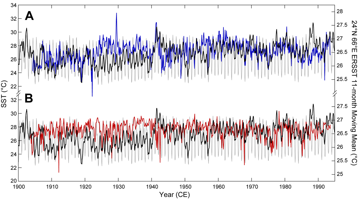
Unlocking Ultra-High-Resolution Paleothermometry from Sediments
Mass spectrometric imaging techniques used to extract micron-scale organic paleothermometry signatures from Arabian Sea sediments show that they skillfully reflect observations.

Posted inNews
Diagnosing Neptune’s Chilly Summer
A pandemic project analyzing a trove of infrared images revealed an unexplained phenomenon taking place in Neptune’s atmosphere.

Posted inNews
Robotic Vehicles Explore World War II Era Ocean Battlefields
Project Recover used autonomous underwater vehicles to identify, access, and image hard-to-reach World War II wreckage sites near the Northern Mariana Islands.

Posted inResearch Spotlights
Testing a Machine Learning Approach to Geophysical Inversion
Variational autoencoders can be leveraged to provide an effective method of inversion that is both accurate and computationally efficient.