• About
  • Sections
  • Topics
    • Climate
    • Earth Science
    • Oceans
    • Space & Planets
    • Health & Ecosystems
    • Culture & Policy
    • Education & Careers
    • Opinions
  • Projects
    • ENGAGE
    • Editors’ Highlights
    • Editors’ Vox
    • Eos en Español
    • Eos 简体中文版
    • Print Archive
  • Blogs
    • Research & Developments
    • The Landslide Blog
  • Newsletter
  • Submit to Eos
  • AGU.org
  • Career Center
  • Join AGU
  • Give to AGU
  • About
  • Sections
  • Topics
    • Climate
    • Earth Science
    • Oceans
    • Space & Planets
    • Health & Ecosystems
    • Culture & Policy
    • Education & Careers
    • Opinions
  • Projects
    • ENGAGE
    • Editors’ Highlights
    • Editors’ Vox
    • Eos en Español
    • Eos 简体中文版
    • Print Archive
  • Blogs
    • Research & Developments
    • The Landslide Blog
  • Newsletter
  • Submit to Eos
Skip to content
  • AGU.org
  • Career Center
  • Join AGU
  • Give to AGU
Eos

Eos

Science News by AGU

Support Eos
Sign Up for Newsletter
  • About
  • Sections
  • Topics
    • Climate
    • Earth Science
    • Oceans
    • Space & Planets
    • Health & Ecosystems
    • Culture & Policy
    • Education & Careers
    • Opinions
  • Projects
    • ENGAGE
    • Editors’ Highlights
    • Editors’ Vox
    • Eos en Español
    • Eos 简体中文版
    • Print Archive
  • Blogs
    • Research & Developments
    • The Landslide Blog
  • Newsletter
  • Submit to Eos

imagery

Study of three glaciers in Greenland
Posted inEditors' Highlights

Small Seismic Signals Tell a Story of Iceberg Calving

by Olga Sergienko 8 August 20198 December 2022

Seismic signals detected hundreds of kilometers away from Greenland glaciers reveal the calving style and iceberg size.

Black-and-orange illustration of a black hole and accretion disk
Posted inNews

New Proof That Accretion Disks Align with Their Black Holes

Rachel Crowell, Science Writer by Rachel Crowell 10 July 201924 May 2022

In the most detailed and highest-resolution black hole simulation to date, an international team of researchers showed the Bardeen-Petterson effect for the first time.

Satellite image of a fire in Northern California
Posted inNews

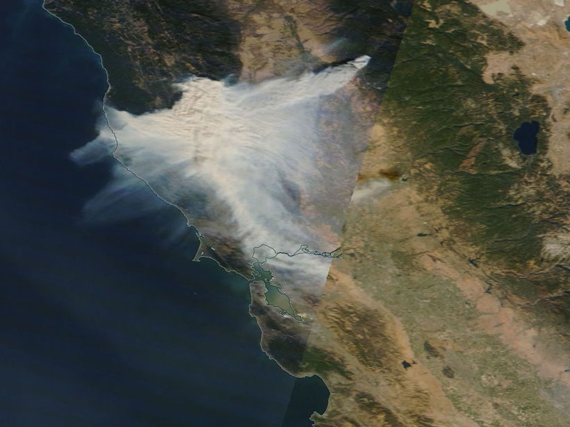
New Eyes on Wildfires

Jon Kelvey, Science Writer by Jon Kelvey 30 April 20195 September 2023

Onboard machine learning and compact thermal imaging could turn satellites into real-time fire management tools to help officials on the ground.

Posted inEditors' Highlights

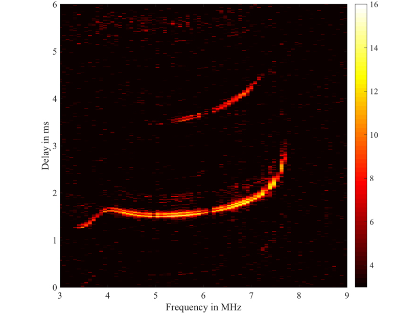
High Resolution Imaging of Ionosphere by Lightning

by V. Pasko 14 December 20185 July 2022

The three-dimensional distribution of electron density in the Earth’s ionosphere could be obtained using the broadband radiation of naturally occurring lightning discharges.

Researchers discuss the potential for machine learning applications in space science
Posted inScience Updates

Space Weather in the Machine Learning Era

by Enrico Camporeale, S. Wing and J. Johnson 6 July 2018

Space Weather: A Multi-disciplinary Approach; Leiden, Netherlands, 25–29 September 2017

NASA's TWINS (Two Wide-angle Imaging Neutral-atom Spectrometers) Mission
Posted inEditors' Vox

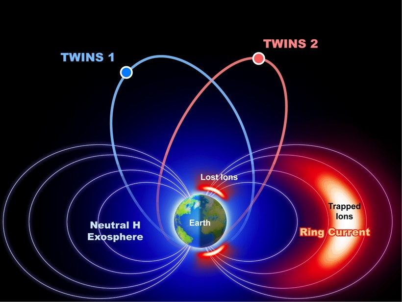
The Big Picture in Geospace

by J. Goldstein 28 March 20184 May 2022

A NASA stereo-imaging mission called TWINS continues to push the boundaries of what we know about the region of space close to Earth.

Frequent saltwater incursions make this area inhospitable, but certain microbes thrive in those conditions, creating extensive microbial mats that gradually turn into calcite and dolomite rock.
Posted inNews

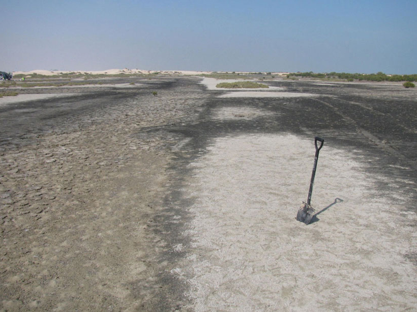
Images Suggest a Viral Role in Some Rock Formation

Bas den Hond, Science Writer by Bas den Hond 26 March 201822 February 2022

Viruses might have helped transform dense bacterial colonies into a type of sedimentary rock that is frequently associated with underground oil reserves.

Posted inEditors' Highlights

The Many Magmatic Modifications to the African Continent

by J. Geissman 9 January 20185 October 2022

How the very slow moving African Continent, with a lithosphere of quite varied age elements and thickness, has responded to ongoing asthenospheric modification.

Researchers validate a new imaging method to characterize coal fractures
Posted inResearch Spotlights

Testing a New Tool That Illuminates Tiny Fractures in Coal

Sarah Stanley, Science Writer by Sarah Stanley 4 January 201815 March 2022

A computational model outperforms a widely used microcomputed tomography imaging method in characterizing coal fractures.

AGU Explorer, first-prize-winning app featuring a map that breaks down Fall Meeting data by location.
Posted inAGU News

AGU’s Developer Contest Unlocks Scientific Research

Chris McEntee, executive director and CEO of AGU by Chris McEntee 21 November 20179 December 2022

Announcing its Open API Challenge winners, the American Geophysical Union explores what open data mean for science.

Posts pagination

Newer posts 1 2 3 4 5 6 Older posts
A view of a Washington, D.C., skyline from the Potomac River at night. The Lincoln Memorial (at left) and the Washington Monument (at right) are lit against a purple sky. Over the water of the Potomac appear the text “#AGU24 coverage from Eos.”

Features from AGU Publications

Research Spotlights

Simplicity May Be the Key to Understanding Soil Moisture

23 May 202523 May 2025
Editors' Highlights

Creep Cavitation May Lead to Earthquake Nucleation

22 May 202521 May 2025
Editors' Vox

Decoding Crop Evapotranspiration

6 May 20256 May 2025
Eos logo at left; AGU logo at right

About Eos
ENGAGE
Awards
Contact

Advertise
Submit
Career Center
Sitemap

© 2025 American Geophysical Union. All rights reserved Powered by Newspack