• About
  • Sections
  • Topics
    • Climate
    • Earth Science
    • Oceans
    • Space & Planets
    • Health & Ecosystems
    • Culture & Policy
    • Education & Careers
    • Opinions
  • Projects
    • ENGAGE
    • Editors’ Highlights
    • Editors’ Vox
    • Eos en Español
    • Eos 简体中文版
    • Print Archive
  • Science Policy Tracker
  • Blogs
    • Research & Developments
    • The Landslide Blog
  • Newsletter
  • Submit to Eos
  • AGU.org
  • Career Center
  • Join AGU
  • Give to AGU
  • About
  • Sections
  • Topics
    • Climate
    • Earth Science
    • Oceans
    • Space & Planets
    • Health & Ecosystems
    • Culture & Policy
    • Education & Careers
    • Opinions
  • Projects
    • ENGAGE
    • Editors’ Highlights
    • Editors’ Vox
    • Eos en Español
    • Eos 简体中文版
    • Print Archive
  • Science Policy Tracker
  • Blogs
    • Research & Developments
    • The Landslide Blog
  • Newsletter
  • Submit to Eos
Skip to content
  • AGU.org
  • Career Center
  • Join AGU
  • Give to AGU
Eos

Eos

Science News by AGU

Support Eos
Sign Up for Newsletter
  • About
  • Sections
  • Topics
    • Climate
    • Earth Science
    • Oceans
    • Space & Planets
    • Health & Ecosystems
    • Culture & Policy
    • Education & Careers
    • Opinions
  • Projects
    • ENGAGE
    • Editors’ Highlights
    • Editors’ Vox
    • Eos en Español
    • Eos 简体中文版
    • Print Archive
  • Science Policy Tracker
  • Blogs
    • Research & Developments
    • The Landslide Blog
  • Newsletter
  • Submit to Eos

landscape & topography

Sinkholes forced the closure of Ein Gedi, an Israeli tourist resort on the shore of the Dead Sea, in 2016
Posted inNews

Subsurface Imaging Sheds Light on Dead Sea Sinkholes

Katherine Kornei, Science Writer by Katherine Kornei 12 October 201824 August 2023

Using seismic waves, researchers study sediment layering near the Dead Sea to reveal how the area’s numerous sinkholes form.

Researchers create a new model to characterize landslide hazards in real time
Posted inResearch Spotlights

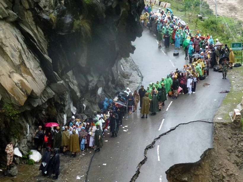
A Near-Real-Time Tool to Characterize Global Landslide Hazards

by Terri Cook 10 May 201818 October 2022

By fusing susceptibility information with precipitation data, a new model generates “nowcasts” to predict the potential for rainfall-triggered landslides in steep terrain between 50°N and 50°S.

Researchers improve climate models by including Himalayan topography and land-atmosphere interactions.
Posted inResearch Spotlights

A Better Way to Predict the Indian Monsoon

by E. Underwood 4 May 201815 February 2023

A new study finds that including Himalayan topography and land-atmosphere interactions improves climate models.

Researchers study the Prairie-Pothole Region of North America to assess water resource management across the continent.
Posted inResearch Spotlights

Prairies, Potholes, and Public Policy

by S. Witman 15 March 201824 January 2024

Studying the Prairie-Pothole Region of North America could help improve water resource management across the continent.

Posted inEditors' Vox

A Landscape Shaped by Wind

by Z. Dong 8 March 201824 February 2022

High-altitude aeolian research on the Tibetan Plateau offers insights into the past, present, and future.

Posted inEditors' Highlights

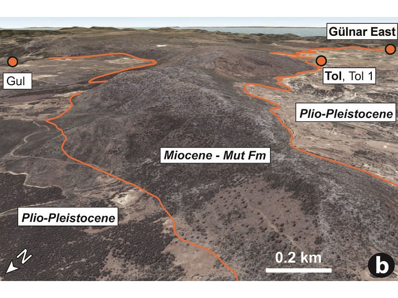
Tracking Deep-Earth Processes from Rapid Topographic Changes

by T. Schildgen 23 February 201818 April 2022

Rapid elevation-rise in Turkey, tracked by marine sediments that now sit at 1.5 km in elevation, is linked to deep-Earth processes that can explain short-lived, extreme rates of topographic change.

Researchers compare observations and modeling to track the growth of drumlins beneath a surge-type glacier
Posted inResearch Spotlights

A New Model of Drumlin Formation

by Terri Cook 8 February 201823 March 2023

Observations from the surge-type glacier Múlajökull in Iceland underpin new modeling results that suggest the glacier’s drumlins grow during quiet intervals of normal flow between glacial surges.

Wheat fields painting
Posted inGeoFIZZ

A Window into the Emerging Anthropocene…Through Art

JoAnna Wendel, freelance science writer and illustrator by JoAnna Wendel 9 January 20184 October 2022

Want a snapshot of how humans have been changing their landscapes since the Industrial Revolution? Look at artwork at a local museum, one geoscientist says.

Posted inAGU News

Eric F. Wood Receives 2017 Robert E. Horton Medal

by AGU 20 December 201711 April 2023

Eric F. Wood was awarded the 2017 Robert E. Horton Medal at the American Geophysical Union Fall Meeting Honors Ceremony, held on 13 December 2017 in New Orleans, La. The medal is for “outstanding contributions to hydrology.”

A color-shaded relief image made from the 5-meter mosaic of ArcticDEM shows a portion of the Brooks Range on the North Slope of Alaska
Posted inNews

Map Provides High-Resolution Look at Nearly Entire Arctic Region

by Randy Showstack 24 October 201718 April 2023

Researchers highlight the value of the time element incorporated into imagery and having a baseline for revisiting and comparing topography.

Posts pagination

Newer posts 1 … 9 10 11 12 13 14 Older posts
A view of a Washington, D.C., skyline from the Potomac River at night. The Lincoln Memorial (at left) and the Washington Monument (at right) are lit against a purple sky. Over the water of the Potomac appear the text “#AGU24 coverage from Eos.”

Features from AGU Publications

Research Spotlights

Lab Setup Mimics Arctic Erosion

14 November 202514 November 2025
Editors' Highlights

Understanding Relative Atmospheric Roles of Anvil and In-situ Cirrus Clouds

17 November 202517 November 2025
Editors' Vox

Announcing New AGU Journal Editors-in-Chief Starting in 2026

12 November 202513 November 2025
Eos logo at left; AGU logo at right

About Eos
ENGAGE
Awards
Contact

Advertise
Submit
Career Center
Sitemap

© 2025 American Geophysical Union. All rights reserved Powered by Newspack