• About
  • Special Reports
  • Topics
    • Climate
    • Earth Science
    • Oceans
    • Space & Planets
    • Health & Ecosystems
    • Culture & Policy
    • Education & Careers
    • Opinions
  • Projects
    • Postcards From the Field
    • ENGAGE
    • Editors’ Highlights
    • Editors’ Vox
    • Eos en Español
    • Eos 简体中文版
    • Print Archive: 2015–2025
  • Policy Tracker
  • Blogs
    • Research & Developments
    • The Landslide Blog
  • Newsletter
  • Submit to Eos
  • AGU.org
  • Career Center
  • Join AGU
  • Give to AGU
  • About
  • Special Reports
  • Topics
    • Climate
    • Earth Science
    • Oceans
    • Space & Planets
    • Health & Ecosystems
    • Culture & Policy
    • Education & Careers
    • Opinions
  • Projects
    • Postcards From the Field
    • ENGAGE
    • Editors’ Highlights
    • Editors’ Vox
    • Eos en Español
    • Eos 简体中文版
    • Print Archive: 2015–2025
  • Policy Tracker
  • Blogs
    • Research & Developments
    • The Landslide Blog
  • Newsletter
  • Submit to Eos
Skip to content
  • AGU.org
  • Career Center
  • Join AGU
  • Give to AGU
Eos

Eos

Science News by AGU

Support Eos
Sign Up for Newsletter
  • About
  • Special Reports
  • Topics
    • Climate
    • Earth Science
    • Oceans
    • Space & Planets
    • Health & Ecosystems
    • Culture & Policy
    • Education & Careers
    • Opinions
  • Projects
    • Postcards From the Field
    • ENGAGE
    • Editors’ Highlights
    • Editors’ Vox
    • Eos en Español
    • Eos 简体中文版
    • Print Archive: 2015–2025
  • Policy Tracker
  • Blogs
    • Research & Developments
    • The Landslide Blog
  • Newsletter
  • Submit to Eos

landslides

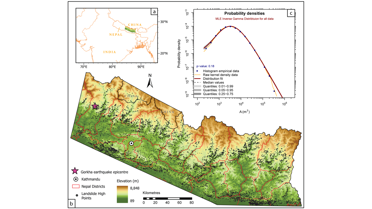
Map of the central-eastern Nepal Himalaya showing the locations of more than 12,800 landslides over a 30-year period.
Posted inEditors' Highlights

History Matters When Gauging Hillslope Susceptibility to Failure

by Matthew Brain 24 March 202212 April 2022

Using susceptibility models to forecast the potential locations of landslides is a key tool in mitigating landslide hazard, but are existing approaches appropriate in dynamic mountainous settings?

Satellite image of Anak Krakatau, Indonesia, with one slope covered in sediment.
Posted inENGAGE, News

Which Came First, the Eruption or the Landslide?

by Saima May Sidik 25 February 202227 March 2023

Anak Krakatau’s eruption was accompanied by a devastating tsunami. But was the eruption to blame?

Overhead image from rescue helicopter of damage in the path of a debris flow at the base of burned hills in Montecito, Calif.
Posted inNews

No Relief from Rain: Climate Change Fuels Compound Disasters

by Leah Campbell 17 December 202117 December 2021

Climate change is increasing the risk of fire-rain events, raising mudslide concerns in fire-prone communities.

Active layer detachments in the Brooks Range, Alaska
Posted inResearch Spotlights

Ice Lenses May Cause Many Arctic Landslides

by Morgan Rehnberg 13 August 202120 October 2021

When permafrost thaw reaches concentrations of ice underneath the surface, it may trigger local soil instability.

Aerial view of a large mudslide that flowed down a forested hillslope and into a small community
Posted inScience Updates

Satellites Support Disaster Response to Storm-Driven Landslides

by R. Emberson, D. B. Kirschbaum, T. Stanley, P. Amatya and S. Khan 9 August 202119 November 2021

Extreme precipitation can trigger deadly landslides. Satellite-based tools provide regional perspectives on landslide hazards, help assess risks in near-real time, and guide emergency responses.

The research vessel CCGS Hudson in Southwind Fjord, Baffin Island, with the iceberg that initiated a submarine landslide in the background.
Posted inNews

An Iceberg May Have Initiated a Submarine Landslide

by Andrew Chapman 20 July 20218 November 2022

A new study shows that icebergs may initiate submarine landslides when they collide with the seafloor.

Debris flows during the largest rainstorm following the 2009 Station Fire in California.
Posted inResearch Spotlights

The Wildfire One-Two: First the Burn, Then the Landslides

Aaron Sidder, freelance science writer by Aaron Sidder 22 June 202128 September 2021

Severe wildfires strip away plant cover and reduce the soil’s ability to hold water. A new study develops a model to better understand landslide risk following a burn.

Map of the study site in the northern California Coast Ranges.
Posted inEditors' Highlights

Thickness and Strength of Slow-moving Landslides Revealed

by O. Marc 22 April 20216 February 2023

Hundreds of slow-moving landslides’ deformation patterns were inverted to obtain their thickness and frictional strength, revealing that larger landslides are weaker and thinner than smaller ones.

People stand atop debris from a huge slump landslide in Uganda.
Posted inNews

Landslides Mar the “Pearl of Africa”

by H. Mafaranga 19 April 20212 August 2022

Behind Uganda’s lavish beauty, climate change has taken its toll: Death, destroyed properties, and displaced communities increase as above-normal rainfall floods the country.

Buildings cling to a soil cliff cut away by a flood.
Posted inNews

Development and Climate Change Contribute to a Himalayan Tragedy

by T. V. Padma 3 March 202112 April 2022

Infrastructure projects like roads and dams destabilize slopes and compound the effects of glacial floods and avalanches, scientists say.

Posts pagination

Newer posts 1 … 41 42 43 44 45 … 49 Older posts
Over a dark blue-green square appear the words Special Report: The State of the Science 1 Year On.

Features from AGU Publications

Research Spotlights

The Economic Costs of Solar Storms

4 September 20264 September 2026
Editors' Highlights

Unveiling Atmospheric Circulation on Mars with Magnetic Field Data 

3 September 20261 September 2026
Editors' Vox

AGU Launches New Special Collection at the Nexus of Science and Policy

3 September 20263 September 2026
Eos logo at left; AGU logo at right

About Eos
ENGAGE
Awards
Contact

Advertise
Submit
Career Center
Sitemap

© 2026 American Geophysical Union. All rights reserved Powered by Newspack