• About
  • Special Reports
  • Topics
    • Climate
    • Earth Science
    • Oceans
    • Space & Planets
    • Health & Ecosystems
    • Culture & Policy
    • Education & Careers
    • Opinions
  • Projects
    • Postcards From the Field
    • ENGAGE
    • Editors’ Highlights
    • Editors’ Vox
    • Eos en Español
    • Eos 简体中文版
    • Print Archive: 2015–2025
  • Policy Tracker
  • Blogs
    • Research & Developments
    • The Landslide Blog
  • Newsletter
  • Submit to Eos
  • AGU.org
  • Career Center
  • Join AGU
  • Give to AGU
  • About
  • Special Reports
  • Topics
    • Climate
    • Earth Science
    • Oceans
    • Space & Planets
    • Health & Ecosystems
    • Culture & Policy
    • Education & Careers
    • Opinions
  • Projects
    • Postcards From the Field
    • ENGAGE
    • Editors’ Highlights
    • Editors’ Vox
    • Eos en Español
    • Eos 简体中文版
    • Print Archive: 2015–2025
  • Policy Tracker
  • Blogs
    • Research & Developments
    • The Landslide Blog
  • Newsletter
  • Submit to Eos
Skip to content
  • AGU.org
  • Career Center
  • Join AGU
  • Give to AGU
Eos

Eos

Science News by AGU

Support Eos
Sign Up for Newsletter
  • About
  • Special Reports
  • Topics
    • Climate
    • Earth Science
    • Oceans
    • Space & Planets
    • Health & Ecosystems
    • Culture & Policy
    • Education & Careers
    • Opinions
  • Projects
    • Postcards From the Field
    • ENGAGE
    • Editors’ Highlights
    • Editors’ Vox
    • Eos en Español
    • Eos 简体中文版
    • Print Archive: 2015–2025
  • Policy Tracker
  • Blogs
    • Research & Developments
    • The Landslide Blog
  • Newsletter
  • Submit to Eos

remote sensing

Two figures from the paper that show wave measurements in the presence of sea ice using satellite remote sensing.
Posted inEditors' Highlights

Satellites Remotely Measure Ocean Waves and Sea Ice Interactions

by Ryan P. Mulligan 12 July 202215 September 2025

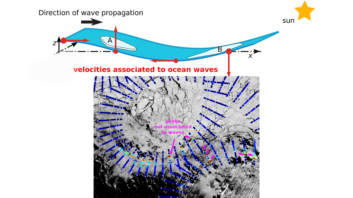
A new method for using satellite observations from multiple sensors improves measurements of ocean waves as they propagate through and interact with sea ice.

Photo of a scientist drilling into lake ice to take a sample.
Posted inEditors' Vox

A Future Without Ice Cover

by Steven Sadro and Marguerite A. Xenopoulos 11 July 202221 July 2022

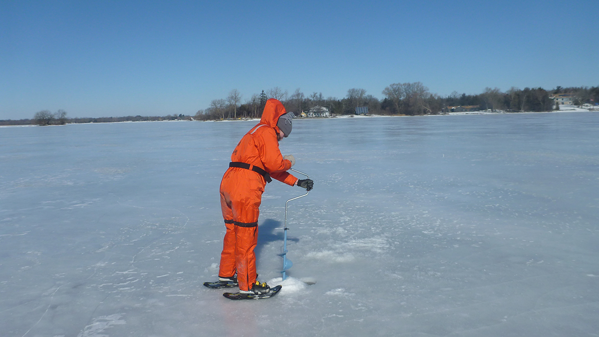
Winter is fading away, but the answers may be beneath the ice; a new collection on winter limnology tackles the unknowns.

Photograph of a volcano erupting.
Posted inEditors' Vox

Dynamics of Volcanic Processes

by Olivier Roche, Yosuke Aoki, Nikolai Bagdassarov, Michael Heap, Sigrun Hreinsdottir, Qinghua Huang, Daniel Pastor-Galán, Michael Poland, Maria Sachpazi, Fang-Zhen Teng, Gregory P. Waite, Marie Edmonds, Paul Asimow, Minghua Zhang and Graziella Caprarelli 6 July 202220 September 2022

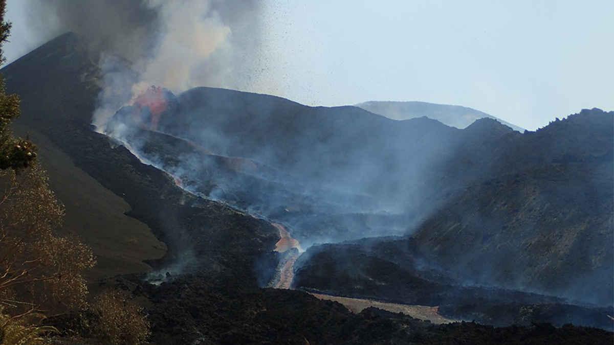
A new cross-journal special collection invites contributions on modern approaches used to investigate dynamics of volcanic processes.

Floating water hyacinths with trapped plastics.
Posted inNews

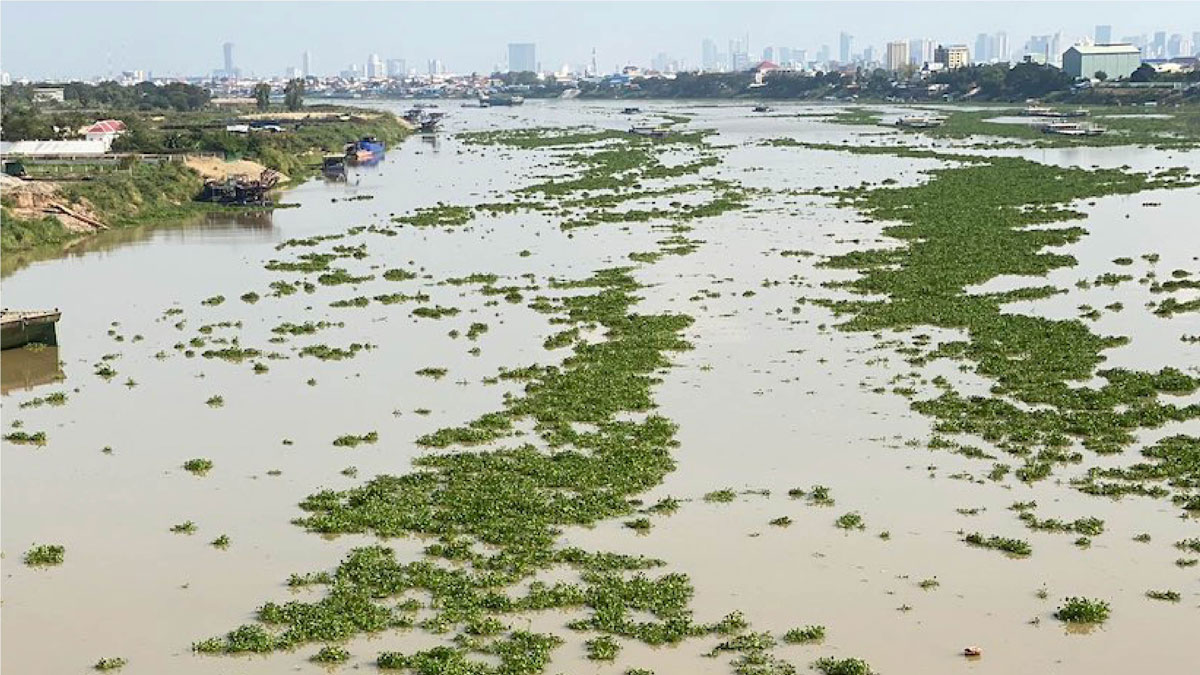
Remote Sensing Tracks Down “Plastic Plants” in Rivers

by Clarissa Wright 28 June 2022

Researchers are using remote sensing to track floating mats of plastic trapped in water hyacinth plants.

Palm swamp in Peru
Posted inNews

Peeking at Peatlands: Satellite Data Fuel New Findings

Adityarup Chakravorty, freelance science writer by Adityarup Chakravorty 15 June 202229 June 2022

Researchers are combining hard-to-get field measurements with satellite imagery to gain new insight into where peatlands are and how they work.

A team of researchers stands in front of an airplane in Antarctica.
Posted inNews

Newly Discovered Lake May Offer a Glimpse into Antarctica’s Past

by Andrew J. Wight 9 June 20229 June 2022

Scientists dive in—metaphorically—to Lake Snow Eagle, only recently revealed through ice-penetrating radar.

Niveau du lac du Nyiragongo au cours du temps.
Posted inEditors' Highlights

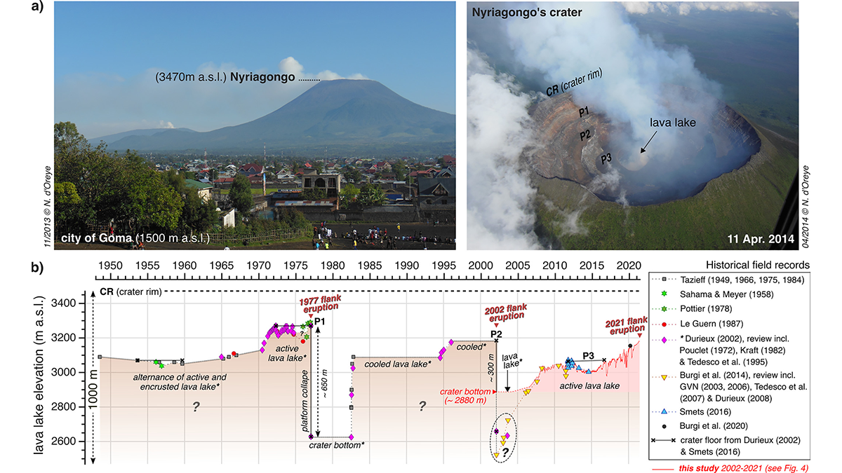
Mesurer les oscillations d’un lac de lave depuis l’espace

by Michael Poland 19 May 202221 February 2023

Les images satellite permettent de mesurer les oscillations du lac de lave du Nyiragongo (RD Congo). Ces mesures renseignent sur la dynamique du volcan et aident à anticiper ses éruptions futures.

Lava lake activity over time at the Nyiragongo volcano.
Posted inEditors' Highlights

Tracking Lava Lake Levels at an African Volcano from Space

by Michael Poland 19 May 20222 August 2022

Satellite data from Nyiragongo Volcano, Democratic Republic of Congo, track changes in summit-crater lava levels that provide a window into eruption dynamics and aid in forecasting future activity.

Colapso de la plataforma de hielo Conger
Posted inNews

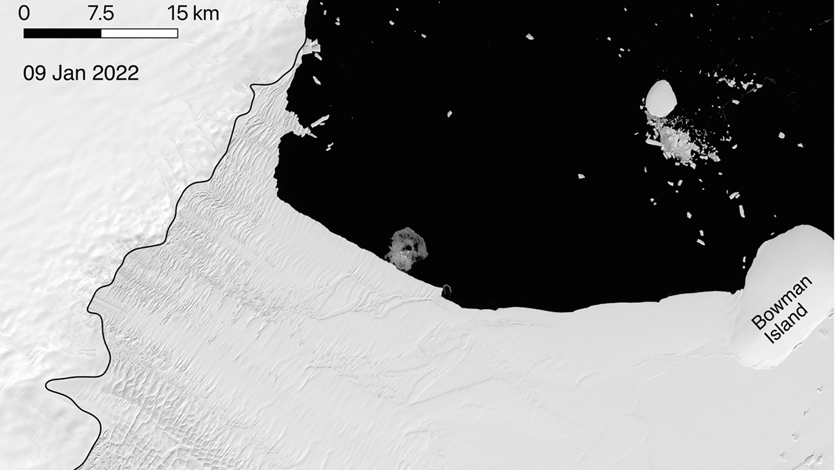
Una nueva pista sobre el colapso de la plataforma de hielo antártica

Jenessa Duncombe, Staff Writer by Jenessa Duncombe 10 May 202210 May 2022

Un tipo particular de tormenta coincidió con 13 de los 21 eventos recientes de desprendimiento en la Antártida.

Average annual water consumption in each province of China
Posted inEditors' Highlights

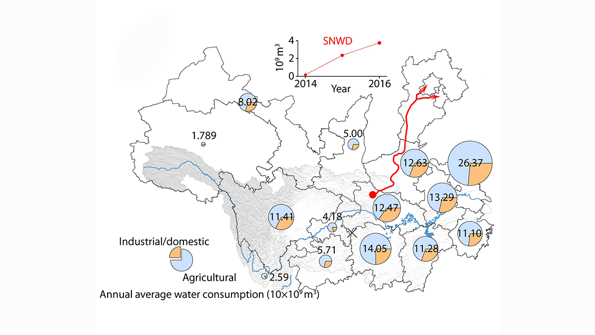
Improved Understanding of Runoff Dynamics in the Yangtze River Basin

by Le Chang 2 May 20227 September 2022

Satellite data combined with in-situ observations on terrestrial water storage change and human water consumption provides a more accurate picture of runoff dynamics at sub-basin scale.

Posts pagination

Newer posts 1 … 7 8 9 10 11 … 38 Older posts
Over a dark blue-green square appear the words Special Report: The State of the Science 1 Year On.

Features from AGU Publications

Research Spotlights

As Wildfires Increase in the West, So Does Suppression Spending

10 June 202610 June 2026
Editors' Highlights

Pre-Existing Structure and Stress Shape Geothermal-Induced Seismicity

2 June 20261 June 2026
Editors' Vox

Small-Scale Indian Ocean Dynamics Underpin Marine Ecology and Climate

4 June 20263 June 2026
Eos logo at left; AGU logo at right

About Eos
ENGAGE
Awards
Contact

Advertise
Submit
Career Center
Sitemap

© 2026 American Geophysical Union. All rights reserved Powered by Newspack