• About
  • Sections
  • Topics
    • Climate
    • Earth Science
    • Oceans
    • Space & Planets
    • Health & Ecosystems
    • Culture & Policy
    • Education & Careers
    • Opinions
  • Projects
    • Postcards From the Field
    • ENGAGE
    • Editors’ Highlights
    • Editors’ Vox
    • Eos en Español
    • Eos 简体中文版
    • Print Archive: 2015–2025
  • Science Policy Tracker
  • Blogs
    • Research & Developments
    • The Landslide Blog
  • Newsletter
  • Submit to Eos
  • AGU.org
  • Career Center
  • Join AGU
  • Give to AGU
  • About
  • Sections
  • Topics
    • Climate
    • Earth Science
    • Oceans
    • Space & Planets
    • Health & Ecosystems
    • Culture & Policy
    • Education & Careers
    • Opinions
  • Projects
    • Postcards From the Field
    • ENGAGE
    • Editors’ Highlights
    • Editors’ Vox
    • Eos en Español
    • Eos 简体中文版
    • Print Archive: 2015–2025
  • Science Policy Tracker
  • Blogs
    • Research & Developments
    • The Landslide Blog
  • Newsletter
  • Submit to Eos
Skip to content
  • AGU.org
  • Career Center
  • Join AGU
  • Give to AGU
Eos

Eos

Science News by AGU

Support Eos
Sign Up for Newsletter
  • About
  • Sections
  • Topics
    • Climate
    • Earth Science
    • Oceans
    • Space & Planets
    • Health & Ecosystems
    • Culture & Policy
    • Education & Careers
    • Opinions
  • Projects
    • Postcards From the Field
    • ENGAGE
    • Editors’ Highlights
    • Editors’ Vox
    • Eos en Español
    • Eos 简体中文版
    • Print Archive: 2015–2025
  • Science Policy Tracker
  • Blogs
    • Research & Developments
    • The Landslide Blog
  • Newsletter
  • Submit to Eos

San Francisco

Map of study area
Posted inEditors' Highlights

Radar Satellites Capture Subtle Slip Evolution on Faults

by Cécile Lasserre 30 March 202327 March 2023

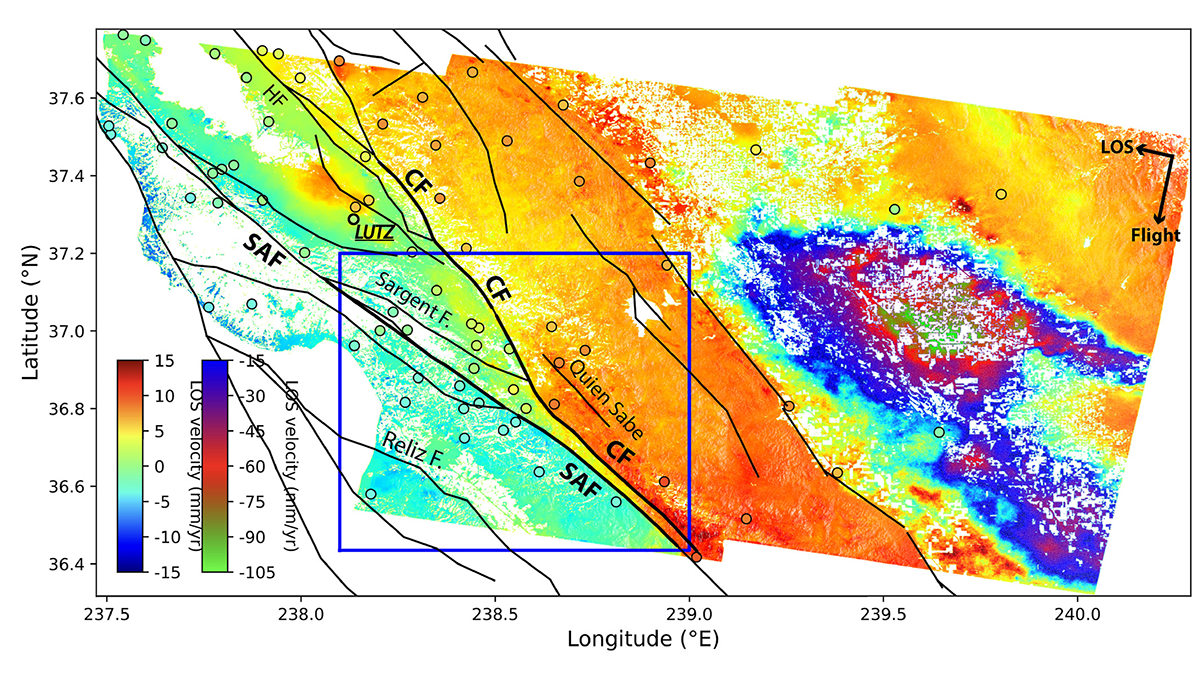
A five-year time series from radar satellite imagery tracks surface slip on major faults in the San Francisco Bay Area, capturing subtle velocity variations and controlling factors.

San Pablo Bay marsh
Posted inResearch Spotlights

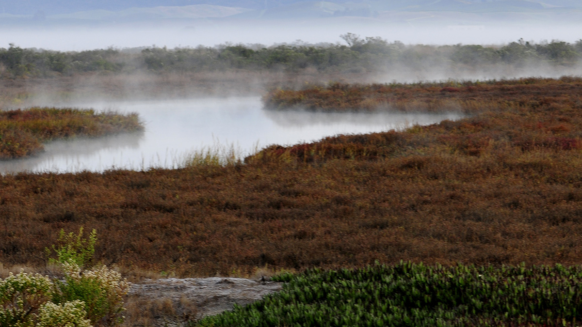
Atmospheric Rivers Help Coastal Wetlands Build Up Sediment

by Alexandra K. Scammell 13 July 202230 January 2024

Accounting for these storms and flooding can help experts predict and respond to rising sea levels.

A white-crowned sparrow sings while perched on a branch
Posted inNews

Birds Sang a New Song During the Pandemic

Katherine Kornei, Science Writer by Katherine Kornei 5 November 20208 September 2022

White-crowned sparrows in the San Francisco Bay Area sang differently during California’s COVID-19-induced shutdown, recordings have revealed.

Aerial view of Oakland, Calif.
Posted inResearch Spotlights

Modeling the Cascading Infrastructure Impacts of Climate Change

Kate Wheeling, freelance science writer by Kate Wheeling 19 October 20201 March 2023

New research highlights how interdependences among infrastructure systems like roads can complicate climate adaptation.

Ring Mountain in California
Posted inAGU News

A Streetcar for the Digital Age

by K. McCarthy 6 December 201910 November 2021

A Streetcar to Subduction for the digital age: AGU revises a classic guidebook using Google Earth.

Black-and-white photo of geologist Clyde Wahrhaftig, looking like a beatnik
Posted inNews

The Layered Legacy of Clyde Wahrhaftig

Korena Di Roma Howley, Science Writer by Korena Di Roma Howley 6 December 20193 November 2022

As the geologist’s beloved guidebook gets a digital makeover, his personal contributions to the field shed light on who he was as a scientist.

New research reveals how sea level rise threatens wastewater treatment plants.
Posted inResearch Spotlights

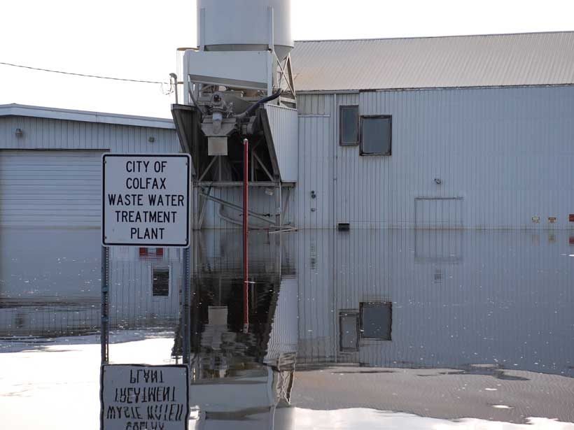
Sea Level Rise Threatens Hundreds of Wastewater Treatment Plants

by E. Underwood 4 May 201828 February 2023

Untreated sewage could affect 5 times more people than direct flooding, a new study shows.

demonstration-near-agu-fall-meeting
Posted inNews

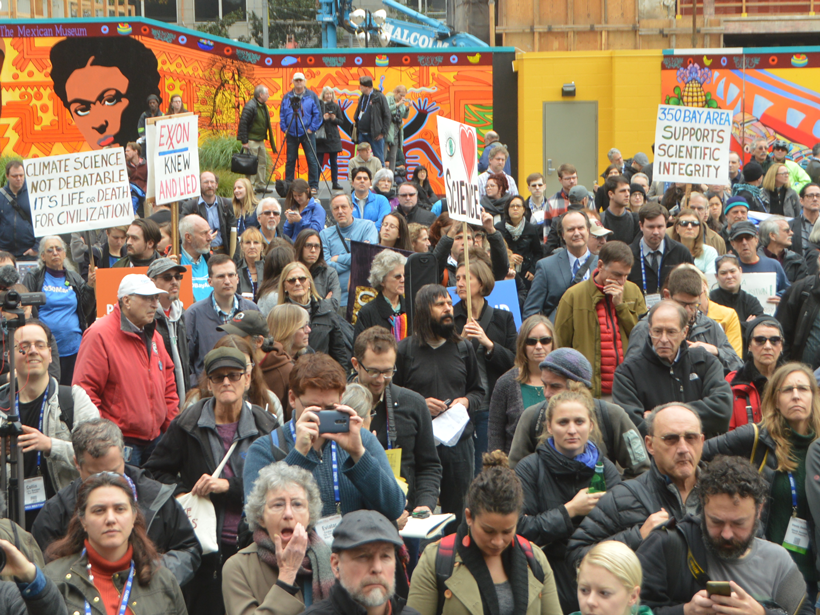
Fearful of Trump, Hundreds in San Francisco Rally for Science

by Randy Showstack 14 December 201627 March 2023

Speakers called on scientists not to remain silent in the face of what they said are threats to the Earth sciences.

A view of a bridge, with the New Orleans skyline visible in the distance between the bridge and the water. A purple tint, a teal curved line representing a river, and the text “#AGU25 coverage from Eos” overlie the photo.

Features from AGU Publications

Research Spotlights

What Could Happen to the Ocean’s Carbon If AMOC Collapses

6 January 20266 January 2026
Editors' Highlights

Frictional Properties of the Nankai Accretionary Prism

11 December 20259 December 2025
Editors' Vox

Hydrothermal Circulation and Its Impact on the Earth System

3 December 20253 December 2025
Eos logo at left; AGU logo at right

About Eos
ENGAGE
Awards
Contact

Advertise
Submit
Career Center
Sitemap

© 2026 American Geophysical Union. All rights reserved Powered by Newspack