
Scientists have developed a consensus guide of standard protocols for how best to measure oceanic primary productivity, a key component in Earth’s carbon cycle.
satellites

Posted inFeatures
Redefining “Glacial Pace”
As Earth’s climate warms, glaciers and ice sheets are retreating, cracking, and adding to sea level rise at record speeds.
Posted inEditors' Highlights
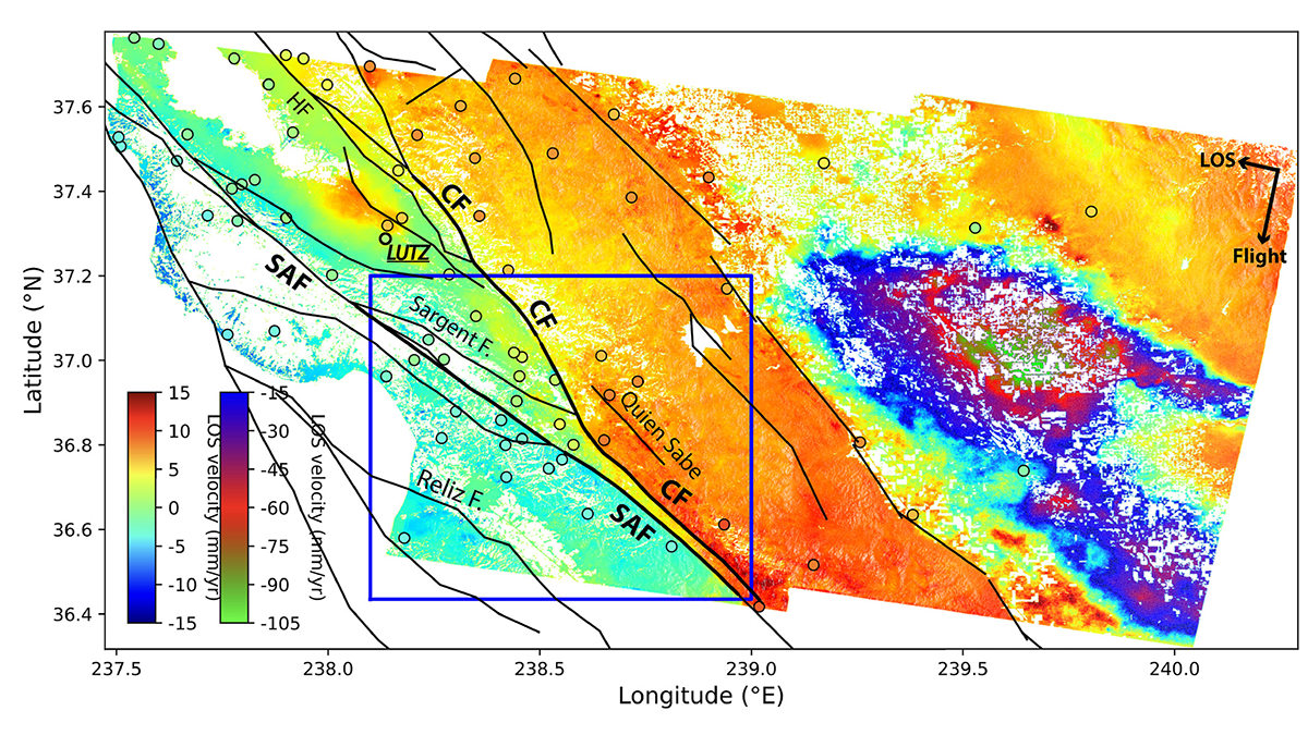
Radar Satellites Capture Subtle Slip Evolution on Faults
A five-year time series from radar satellite imagery tracks surface slip on major faults in the San Francisco Bay Area, capturing subtle velocity variations and controlling factors.

Posted inEditors' Vox
How Big Data is Helping Environmental and Climate Research
A new special collection invites papers focusing on the processing, modeling, and analysis of all types of big datasets in the Earth and space sciences, including the influence of solar forcing on Earth’s climate.
Posted inEditors' Highlights
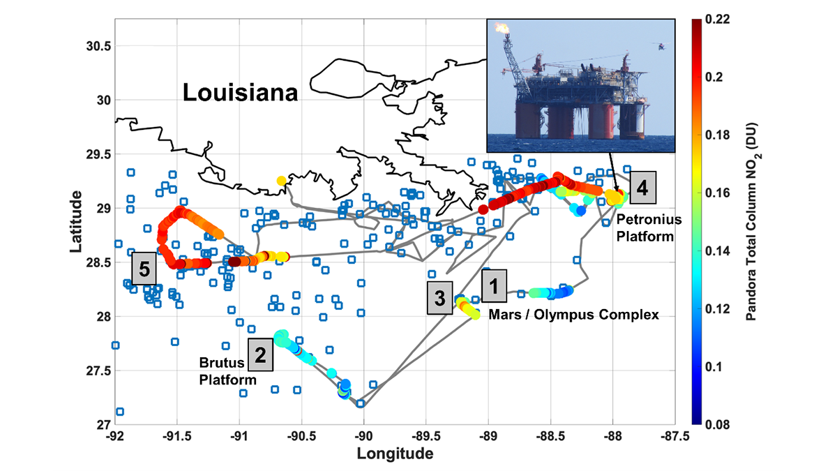
Remote Sensors See NO2 ‘Hot Spots’ from Offshore Oil Activity
Satellites can see NO2 pollution from space, but can they detect individual oil and natural gas operations, and are the measurements accurate?

Posted inEditors' Highlights
Bio-Argo Floats Reveal Phytoplankton Increase at Ocean Fronts
Bio-Argo floats and satellite altimeter data reveal that upwelling caused by confluent flow on the warm side of ocean fronts increases phytoplankton carbon and chlorophyll.

Posted inENGAGE, News
“Revolutionary” Instrument to Watch North American Skies
TEMPO, scheduled for launch this April, will monitor ozone and other pollutants during hourly daytime scans, providing data for better air quality forecasts and atmospheric models.

Posted inScience Updates
How Hail Hazards Are Changing Around the Mediterranean
A new method for studying hailstorms from space offers more consistent and more complete views of how and where hail forms, and how climate change might influence hail’s impacts in the future.
Posted inEditors' Highlights
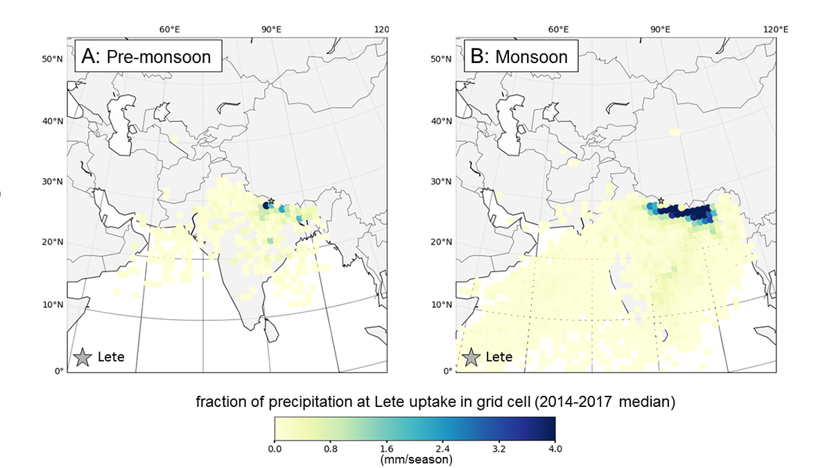
Source of Precipitation Moisture Feeding Himalayan Rivers
Isotope study showing the partitioning of moisture into snow, ice, and groundwater allows an understanding of the relative contribution to river flow to show where Himalayan river water comes from.

Posted inEditors' Vox
The International Reference Ionosphere – A Model Ionosphere
An accurate and reliable description of Earth’s ionosphere is of critical importance because of our increased reliance on satellite technology and the significant impact the ionosphere has on it.