
The Landslide Blog is written by Dave Petley, who is widely recognized as a world leader in the study and management of landslides.

On 12 November 2014, an 8.45 million cubic metre landslide occurred in a mine waste pile at the Dagushan open-pit iron mine in Anshan, China. The failure occurred in a a huge mine waste pile that was in operation between 1955 and 2007, covering an area of about 3.5 km2 and holding over 300 million cubic metres of mining waste materials.
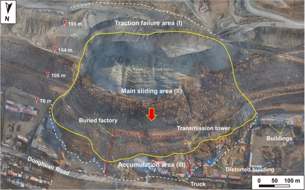
This landslide is described in a new paper that has just been published in the journal Landslides (Sun et al. 2023). The authors have investigated the mechanisms of the failure through lab testing and modelling. In the paper they include this image of the aftermath of the landslide:-
Google Earth has good imagery of the site before the landslide, collected in November 2013:-

The failure had a maximum length of 890 m and a width of 550 m. According to Sun et al. (2023) it destroyed “transport roads, railways, pipelines, and transmission towers on the waste dump slope were destroyed, and many buildings, equipment, and vehicles at the foot of the waste dump were buried”. No-one was killed or injured in the landslide.
The interesting aspect of this landslide is shown in this cross-section from Sun et al. (2023):-
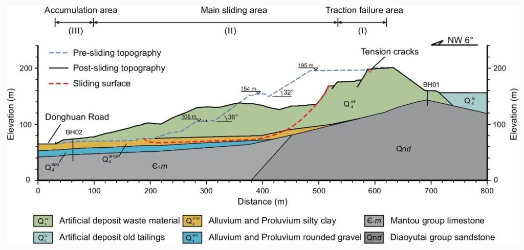
The mine waste had been deposited on a naturally occurring layer of silty clay that had a slight dip parallel to the original slope. Under saturated conditions, this layer was particularly weak. The landslide involved failure through this clay layer, creating a basal shear plane that allowed the remainder of slope to deform. The cross-section above shows the largest rear scarp of the landslide, but note that the mass further upslope had also failed. I think you can extrapolate the likely configuration of the shear plane through the clay layer as it pinched out.
The propensity for failure through weak basal layers under mine waste is easily overlooked. I am reminded of the February 2013 Hatfield – Stainforth landslide in the UK, when coal mine waste triggered failure through saturated gravels.
Failures in mine waste remain a critical issue, although there are signs that the industry is paying greater attention.
Reference
Sun, Sw., Liu, L., Yang, Z. et al. 2023. Toward a sound understanding of a large-scale landslide at a mine waste dump, Anshan, China. Landslides. https://doi.org/10.1007/s10346-023-02136-1