Overview:
A study just published in the journal Catena (Sharma et al. 2024) has generated a new landslide susceptibility map for India.
The Landslide Blog is written by Dave Petley, who is widely recognized as a world leader in the study and management of landslides.

In terms of lives lost from rainfall triggered landslides, India is the worst affected on Earth. The combination of areas of steep topography, high uplift rates, monsoon rainfall and environmental degradation yields multiple fatal landslides every year, with a high cost. If we are to bring down the global cost of landslides, India is a good place to focus.
A starting point for landslide management is a susceptibility map, which allows the most hazardous areas to be identified and the direction of resource to the right places. But generating a susceptibility map for an area the size of India is a real challenge, not least because of uneven datasets.
However, a new study just published in the journal Catena (Sharma et al. 2024) has succeeded in generating a landslide susceptibility map for all of India at a resolution of 0.001°, which is about 100 metres, a remarkable achievement.
This is the resulting landslide susceptibility map for India:-
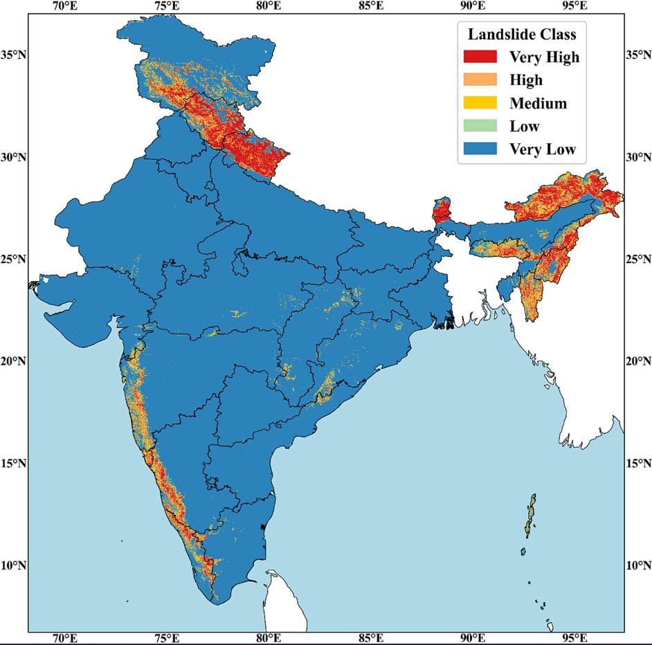
As expected, at the country scale the map shows high landslide susceptibility in the mountains of the Himalayas and associated upland areas, and high susceptibility in the southwest of the country, again associated with areas of high topography and intense monsoon rainfall. However, Sharma et al. (2024) have also identified some areas not previously considered to have high landslide susceptibility, for example in the eastern Ghats. The authors point out that fatal landslides have occurred in this region, as indicated in the dataset that underpinned the paper that Melanie Froude and I wrote about global landslide fatalities (Froude and Petley 2018).
It is worth noting that Sharma et al. (2024) have made their data available. In the paper they cite the following sources:-
“The Indian Landslide Susceptibility Map (ILSM) probability and class data is freely available from
- 1) Zenodo: https://zenodo.org/doi/10.5281/zenodo.10085271
- 2) Google Earth engine:
- var ILSM_class = ee.Image(“projects/ee-nirdeshsharmanith1/assets/ILSM”)
- •var ILSM_probability = ee.Image(“projects/ee-nirdeshsharmanith1/assets/ILSM_probability”)
- 3) Code: https://github.com/hydrosenselab/ILSM“
This study is immensely useful for both developing a new methodology that can be applied elsewhere (Nepal, Pakistan and Bhutan would be good places to start) and for producing a map that should assist landslide management in India. It is an important and useful study.
References
Froude, M.J. and Petley, D.N. 2018. Global fatal landslide occurrence from 2004 to 2016. Natural Hazards and Earth System Science, 18, 2161-2181, doi: 10.5194/nhess-18-2161-2018.
Sharma, N., Saharia, M. and Ramana, G.V. 2024. High resolution landslide susceptibility mapping using ensemble machine learning and geospatial big data,
Catena, 235, 107653. doi: https://doi.org/10.1016/j.catena.2023.107653.