A new paper in the International Journal of Applied Earth Observation and Geoinformation uses InSAR to explore the complex patterns of deformation that occur in and around large mining operations.

I have frequently discussed landslides in mining operations on this site, highlighting repeatedly the unacceptable losses that result from slope failures. In many cases, these landslides occur in mines that are unlicenced and unregulated, but major failures in tailings piles, heap leach pads and mine walls are not uncommon.
An aspect that is rarely considered is what happens to the slopes in mines the aftermath of a major failure. In a study just published in the International Journal of Applied Earth Observation and Geoinformation (Wang et al. 2026), a group of us hve used InSAR to examine this issue for ten case studies from around the world. Tyhe article is behind a paywall, but you should be able to access it here. The article has been published under a Creative Commons licence too.
In each case, we looked at the deformation at the mine site in the years leading up to the failure, and also in the period afterwards. Precursory deformation was clearly visible in each case – this illustration, from the paper, shows the movement that was detected before the landslides occurred, and continues afterwards:-
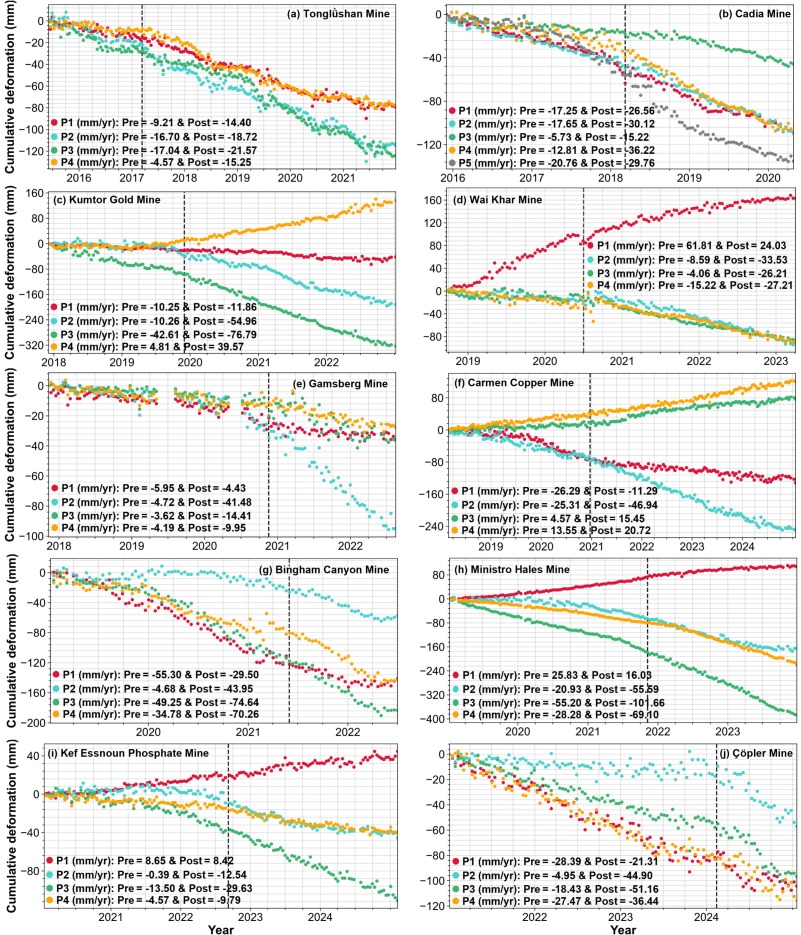
This neatly illustrates a substantial challenge in using InSAR as a tool to detect precursory deformation for major failures. I each case, the InSAR detected movement ahead of the landslide on slopes that did not fail in the key event, and this deformation continued afterwards too. This illustrates a key point – for InSAR to be useful, we need to detect and analyse movement that differentiates between ongoing creep and incipient failure. Analysing slopes that have not failed, but which are creeping, is a key part of this.
Wang et al. (2026) includes rather a nice example of the complexity of ground deformation around mining sites. This is the Cadia Mine in New South Wales, Australia. On 9 March 2018, the Cadia Mine suffered a major failure in a tailings storage facility. The figure below, from Wang et al. (2026), shows deformation at the site before and after failure:-
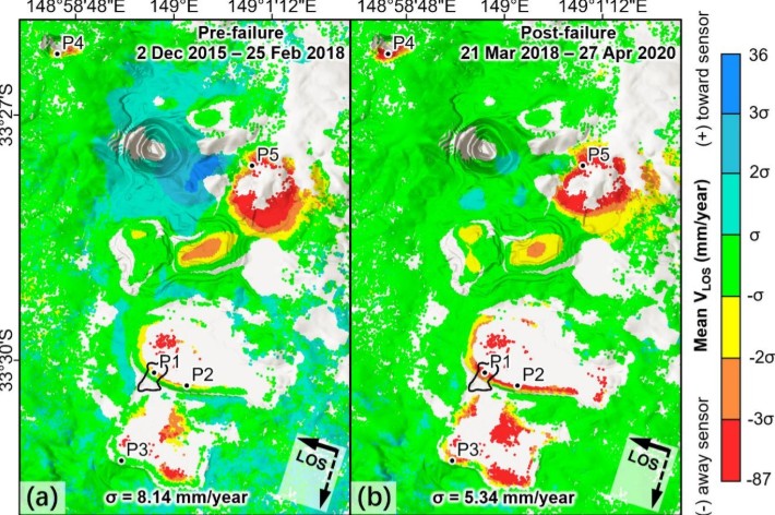
The outline of the tailings failure is shown at point P1. Note that only limited deformation was seen in this area before the tailings failure occurred, and greater levels of deformation were detected in the local area. After the failure, extensive deformation was detected in the tailings storage facility. But a greater cluster of movement was seen to the northeast (around P5 in the image). This looks dramatic, but in reality it was planned. In this area, the mining operation had adopted block caving, with break through to the surface being deliberately planned. This inevitably leads to deformation that is measurable using InSAR.
The key message from Wang et al. (2026) is cautionary – large-scale mining operations cause huge amounts of change to the environment, which will manifest as deformation in InSAR imagery. Only a small proportion of this will lead to slope failures that result in high levels of loss or damage. Reliably detecting the precursory deformation associated with these particular events remains a major challenge.
Reference
Wang, P., Sopaci, E., Petley, D., Deng, H and Tanyaş, H. 2026. Monitoring pre- and post-failure InSAR-derived deformation in surface mining complexes. International Journal of Applied Earth Observation and Geoinformation, 148, 105217.
https://doi.org/10.1016/j.jag.2026.105217.