A major slope failure killed many people, possibly over 300, in an area of unlicenced mining of the mineral Coltan.

On 19 June 2025, a very significant landslide occurred at the Rubaya mining site in Masisi territory, North Kivu, which is located in the eastern part of the Democratic Republic of the Congo (DRC). The landslide, which reportedly affected a place called Bibatama, killed at least 21 people, but in all probability many more people died. Local news site Mines.cd reports over 300 fatalities.
The Rubaya mining area is a large, unlicenced and unregulated shallow excavation for the extraction of Coltan (known industrially as tantalite), an ore from which niobium and tantalum are extracted. The primary use of tantalum is in mobile phones, but it is also used in computer hard drives and road vehicle electronics.
These types of disastrous mining landslides in less developed countries rarely attract much interest (imagine what would have happened if this event had occurred in Canada or Australia), so I decided to see whether I could find anything out about it. I must note that landslides at this site are common – for example, about 100 people were killed in a landslide in 2013.
The Rubaya mining area is well covered in Google Earth – this is an image from 2021. The marker gives the general location – we’ll come back to this spot below:-

Zoom in and you find a landscape scarred by shallow workings and landslides:-

The Rubaya mining area has a very challenging history. In recent years, possession has alternated between the military and various militias, who have run the site as a protection racket. Since April 2024, the site has been controlled by the March 23 Movement (M23), a rebel group with a long history of human rights violations.
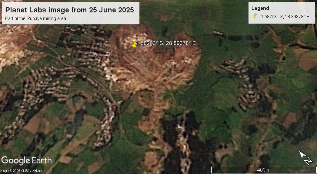
I have been trying to use Planet Labs images to try to identify the location of the 19 June 2025 landslide. I think the most likely location is in the mining area located at [-1.58203, 28.89378]:-

This mining area has expanded rapidly in recent years. The 2021 Google Earth image shows that it has been subject to a number of landslides.
I have downloaded a Planet Labs image from 14 June 2025 – five days before the landslide, and I have draped onto the Google Earth DEM. Of course, the Planet Labs imagery has a lower spatial resolution than the Google Earth imagery:-

The image shows a higher level of mining activity than was the case in 2021, and possibly some further landslides. By comparison, the image below was captured on 25 June 2025, after the landslide:-

And here is a slider to allow the images to be compared:-


I think the landslide is visible on the left side of the mining area. A series of shallow workings have been destroyed, and the track and runout zone of the landslidecan be seen. The feature that is probably the landslide is about 250 metres long.
These types of landslides in unlicenced and unregulated mining sites are a major contributor to global landslide fatalities, but they are rarely investigated.
Finally, in an interesting twist, the FT reported last week that an ally of Donald Trump, Gentry Beach, is seeking to “snap up” the Rubaya mine site.
Reference
Planet Team 2024. Planet Application Program Interface: In Space for Life on Earth. San Francisco, CA. https://www.planet.com/