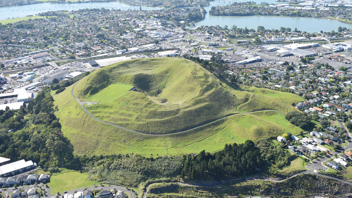
For decades, as Jill Kenny drove around her hometown of Tāmaki Makaurau Auckland, Aotearoa New Zealand, the now-retired geologist and geomorphologist wondered about the shape of the landscape. Auckland, the country’s largest urban area, is located on a volcano-studded isthmus on the North Island. Obvious volcanic mounds aside, why does the city have the shape it does?
Kenny noticed similar flat, eroded surfaces at different heights above sea level and one day in 2004 had an aha moment: Maybe these surfaces were at different elevations because they had been offset by faults. In other places, scientists can trace the echo of fault lines in the landscape or through seismic data, but Auckland has few earthquakes and is covered over by a patchwork of small lava flows and ash deposits, as well as by a modern concrete jungle.
Were there faults hidden beneath the city, and could any of them still be active?
A Passion Project
For years, Kenny trawled through paper and digital records detailing data culled from boreholes drilled through the lava and into Auckland’s underlying sedimentary rock. The boreholes were part of geotechnical investigations conducted for construction purposes and resulted in a total of 2,000 logs.
In those records was evidence of Miocene epoch layers of sandstone and mudstone called the Waitematā Group. The top of this layer, which eroded between 15 million and 5 million years ago, is the “only potential marker horizon that can be followed with any certainty across the Auckland region,” wrote Kenny and University of Auckland volcanologist Jan Lindsay in a 2012 paper describing the borehole research. That study identified a number of previously hidden faults under Auckland, as indicated by adjacent boreholes showing the surface suddenly raised or lowered along a consistent line.
In the years since Kenny and Lindsay’s 2012 paper, Auckland borehole data have proliferated. Logs that were once closely guarded by companies and organizations have been brought together in the New Zealand Geotechnical Database.
“Every little extra piece of information adds to the overall jigsaw puzzle,” said Lindsay.
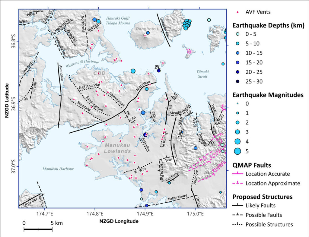
Now, in a new study published in the New Zealand Journal of Geology and Geophysics, Kenny, Lindsay, and colleagues have used information from 8,200 boreholes in addition to new remote sensing and geophysical data to provide a revised model of post-Miocene faulting in the Auckland region. The model includes a new geospatial database, fault maps, and a suggested standard methodology for classifying obscured urban faults. The research identifies 10 likely and 25 possible faults in the region and erases some nonfaults that have been incorrectly propagated through the literature for decades.
“This paper is really a passion project,” said Lindsay. “It was a long, painstaking process, but we think we’ve ended up with a really robust catalog of buried faults in Auckland with a range of different confidences attached to them.”
Finding Urban Faults
While earthquakes are among the deadliest threats to urban areas, cities are tricky places to find faults, said Nicolas Harrichausen, who studies crustal deformation at the University of Alaska Anchorage but was not involved in the New Zealand research. Surface offsets can be just a few meters across, and when a shopping center, road, high-rise, or house is built, evidence of the fault is erased.
Another problem is access. “Say you do find something that is interesting—you can’t go dig a trench in somebody’s yard or dig up a street in the name of finding a potential fault,” said Harrichausen, who recently discovered an active fault in the city of Victoria on Vancouver Island, Canada.
Finally, seismic surveying is one of the most common fault-finding methods, and cities are just seismically noisy places. Vibrations from construction and highways consistently interfere with seismic signals. Some cities restrict or even ban seismic surveys for ecological reasons.
However, cities do have some advantages when compared to places like the extremely remote Alaskan fault he’s currently investigating, Harrichausen said: People are already digging lots of holes.
The new Auckland borehole database is a great starting point for research into the geomorphology of the region, Harrichausen said, but because of the ancient age of the marker horizon, “for earthquake hazard, it’s just kind of a baseline.” The United States considers a fault active if it’s ruptured in the past 12,000 years. In New Zealand, it’s 125,000 years. So far, the faults Kenny and Lindsay have identified can be constrained only to the past 5 million or so years.
“It may be that none of [the suggested Auckland faults] are active,” Lindsay acknowledged. “But we need to better understand our faults and how active they are in order to work out what our actual seismic risk is.”
The study has revealed several compelling candidates for further investigation, she said, including one fault near the peninsula suburb of Bucklands Beach, where offset evidence from the boreholes lines up with a visible scarp through a golf course. “If I were studying faults in Auckland, that’s where I would start,” said Harrichausen.
Where Magma Meets Fault
Even if none of the Auckland faults turn out to be active, for Lindsay, a volcanologist who leads the transdisciplinary Determining Volcanic Risk in Auckland project, the fault maps and database are also the starting point for another line of inquiry with significant implications for the people of the city.
“We need to know as much as we can about the rocks beneath our feet.”
The new maps show that the region’s volcanoes consistently erupted near the faults and associated structures, but not right along them. “Volcanologists are not in agreement as to whether magma prefers to move along faults or whether it prefers to move between faults,” said Lindsay. There seems to be some relationship between the structural fabric of the region and its volcanism, she and her coauthors wrote.
“In order to better understand the active volcanoes in Auckland, we need to know what the subsurface looks like,” Lindsay said. “We need to know the structure, we need to know where the faults are—we need to know as much as we can about the rocks beneath our feet.”
—Kate Evans (@kategevans.bsky.social), Science Writer