
A new paper (He et al. 2026) in the journal Landslides describes the breach of a massive landslide dam in Taiwan, which killed 24 people.

On 23 September 2025, a large landslide dam (located at [23.715, 121.299]) on the Matai’an River in Hualien County in Taiwan catastrophically breached, releasing a flood that left 24 people killed or missing, with a further 156 people injured. A new, open access paper has been published in the journal Landslides (He et al. 2026) that describes both the landslide and the resultant flood. The paper is published under a Creative Comms licence too (so well done to the authors!).
The landslide itself is the largest ever recorded in Taiwan, triggered by Tropical Storm Wipha on 19 July 2025. This image, from the paper, shows the situation on 27 September 2025 (after the breach event had occurred):-
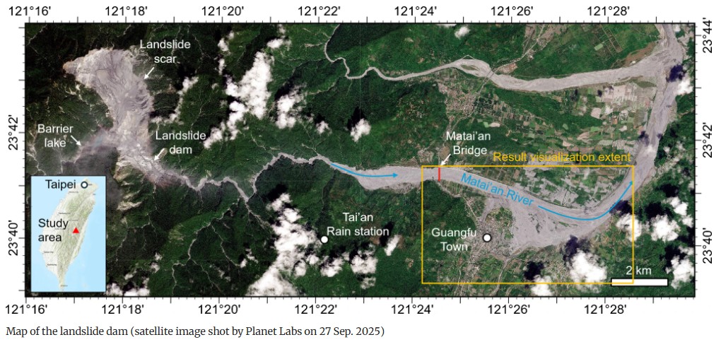
The landslide is visible to the west, with the path of the flood towards the east. The extensive flood damage caused by the breach is also clear.
He et al. (2025) show that the slope that failed to generate this enormous landslide was unstable even before 1985. The slope may have been further destabilised by the 3 February 2024 M=7.4 Hualien Earthquake, and further movement of the slope was triggered by Typhoon Kong-rey in November 2024, which saw the development of a large tension crack. As noted above, the main failure that generated this landslide occurred during Tropical Storm Wipha, which brought 573 mm of rainfall in three days (this is not a particularly exceptional level of rainfall for Taiwan).
The landslide on the Matai’an River was very large – He et al. (2025) have calculated the voume as 285.90 million m3, forming a dam in the valley below that was 200 m high.
The summer months in the Central Mountains of Taiwan involve high levels of rainfall, especially as a Typhoon Podul passed through the area in August 2025. Thus, the lake rapidly filled, reaching a total volume of 67 million m3. Typhoon Ragasa deposited over 700 mm of rainfall at the site, which triggered the breach of the landslide dam on 23 September 2025.
The analysis by He et al. (2025) suggests that the breach generated two peak flow events. The first occurred 15:38 on 23 September 2025, reaching 6,612 m3, followed by a second, larger peak flow at at 16:24 at 9,309 m3. This is a massive flood event for a catchment of this scale.
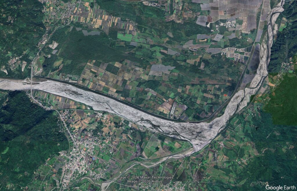
The Google Earth image below shows the flood plain in the main valley below the landsldie dam. This image was collected in January 2024, prior to the breach event. Compare it with the image after the flood, above.
He et al. (2025) estimate that 1,606 buildings were damaged or destroyed by the flood. The authorities were aware of the risks and attempted to evacuate the affected area (records suggest that 8.524 people were relocated), which undoubtedly reduced the losses. The 24 people who lost their lives probably ignored the order to evacuate, a common problem in these scenarios. Thus, the loss of life does not indicate a failure by the authorities.
In the aftermath of the Nepal-Tibet landslide disaster, there has been a great deal of discussion about the value of an early warning system. The landslide on the Matai’an River shows the challenges of these situations. Even in a scenario with a known hazard, a fully understood trigger event (the typhoon) and a very well-developed emergency management system, losses still occur. Operating a system that is providing surveillance over a massively larger area for an event that might have no clearly defined trigger; with the flood impacting a much greater distance; and in a country with lower development of its emergency management system, is infinitely harder.
As always, the focus should be on vulnerability and resilience rather than on magic bullet warning systems.
Reference
He, J., Xiao, S., Lv, Y. et al. 2026. The landslide dam breach disaster in Hualien, Taiwan on 23 September 2025. Landslides. https://doi.org/10.1007/s10346-026-02840-8