
A team of geologists on a September expedition to map a major offshore earthquake fault north of Canada’s Vancouver Island has discovered a surprising geologic feature deep beneath the waves: an active mud volcano with a towering plume of methane and other volcanic gases spewing from it.
Finding the volcano and its 700-meter-tall (2300-foot-tall) gas plume and several other cones along the little-studied Queen Charlotte–Fairweather fault system could provide new insights about how the fault system works, said marine geologist H. Gary Greene of Moss Landing Marine Laboratories in Santa Cruz, Calif., one of the leaders of the expedition.
Coastal Risks
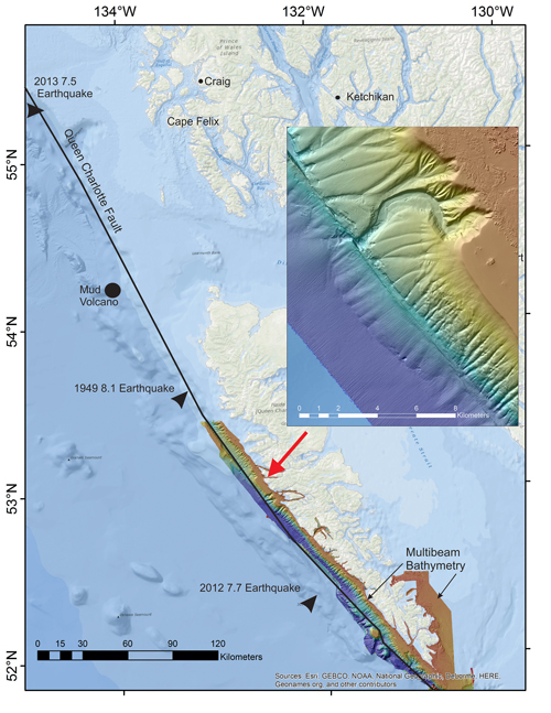
The fault system, which extends to the Fairweather Range in southeast Alaska, has produced multiple magnitude 7+ earthquakes over the past century. Although it runs along a sparsely populated coastline, earthquakes along the fault system could pose significant risks to industry and shipping in the region, noted Mike West of the University of Alaska Fairbanks, who is the state seismologist of Alaska and was not involved in the study.
Directly to the east lie the liquid natural gas plants and port facilities of Prince Rupert. An earthquake rattling loose an underwater landslide could generate deadly tsunamis and wreak havoc on ships carrying crude, gas, and coal to Asia, Greene said.
“It’s easy to write this area off as not densely populated,” West said. “But there’s a growing appreciation of the role played by landslide tsunamis in our hazards.”
Tory O’Connell, research director of the nonprofit Sitka Sound Science Center, told Eos that “Sitka is one of the most active commercial fishing ports in the U.S., with hundreds of vessels home-ported here and hundreds more in the region. Coastal residents are very interested in potential hazards along the fault.” The U.S. Geological Survey Earthquake Hazards Program awarded a grant to the center to support the fault-mapping expedition.
Looking for Landslides
Greene and seven other scientists undertook the expedition aboard the Canadian Coast Guard Ship John P. Tully because they “wanted to learn how large the possible landslides were.” “If they occur along the strike-slip fault, they could produce significant tsunamis,” Greene explained. Older bathymetric mapping indicated irregular slopes, evidence of significant landslides, along the central fault north of Haida Gwaii. The team had also set out to determine the slip rate along the system’s faults.
Greene led the study with the cruise’s chief scientist, geologist Vaughn Barrie of the Geological Survey of Canada (Natural Resources Canada), in Sidney, British Columbia.
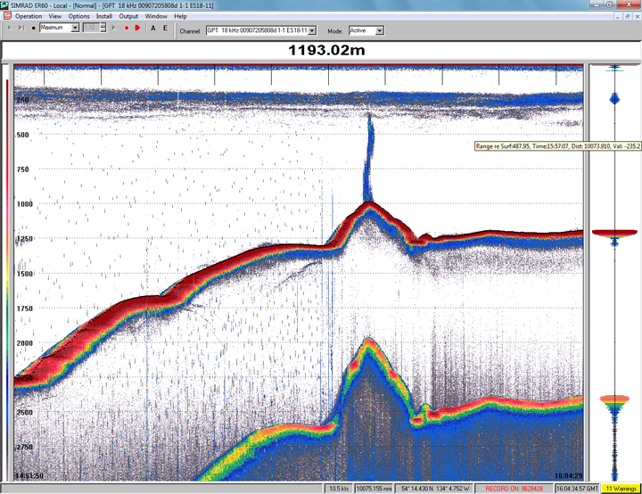
Single-line transects profiling layers of rock under the seafloor revealed the unexpected conical feature. Photos show mussels known to live near methane seeps colonized around the vent. However, samples provided no evidence of recent magma, so the odds of a lava-spewing volcano seemed slight.
Further exploration after the methane plume was spotted on 22 September revealed several other cones along the fault zone, leading the researchers to hypothesize that they had found “a fairly large mud volcano field, which may or may not have igneous origins,” Greene said. Detailed analyses of surface sediments, sediment cores, and seismic data confirmed that hypothesis earlier this month, he added.
Fluid Role?
The presence of mud volcanoes, conical mounds formed when subsurface gases and muddy sediments erupt from underground, suggests that fluids may play a major role in facilitating movement along the fault zone, Greene said.
Friction between rock surfaces on either side can lock a fault. If a lubricating fluid, say from a gas seep or clay minerals, eases that friction, the fault can creep along and reduce local stress buildup while staying locked elsewhere.
Understanding the Queen Charlotte–Fairweather fluidity could provide insight to other faults, Greene added. Data can be extrapolated, for instance, to the northern part of the Cascadia subduction zone, which stretches from northern Vancouver Island to northern California and has received much scrutiny for the earthquake and tsunami risks it poses to the densely populated Pacific Northwest coasts of the United States and Canada.
Greene said that he and his colleagues are seeking further support to do more seafloor mapping along the fault. A more thorough survey should help tell the story of the new volcanic-like features and further explain this unique fluid-loaded fault, he predicted.
—Rachel Berkowitz, Freelance Science Journalist; [email protected]
Citation: Berkowitz, R. (2015), Active mud volcano field discovered off southeast Alaska, Eos, 96, https://doi.org/10.1029/2015EO040447. Published on 30 November 2015.
Text © 2015. The authors. CC BY-NC 3.0
Except where otherwise noted, images are subject to copyright. Any reuse without express permission from the copyright owner is prohibited.