On 6 February 2023, a pair of powerful earthquakes—magnitudes 7.8 and 7.5—struck southern Türkiye and northwestern Syria 9 hours apart, killing 59,000 people and causing catastrophic damage.
While in the area mapping earthquake-triggered landslides the following month, Istanbul Technical University geomorphologist Tolga Görüm and his team noticed an atmospheric river approaching the disaster zone. They found this worrying, because an earthquake can weaken surrounding slopes for months and possibly years, making them vulnerable to heavy rainfall.
In a recent Communications Earth & Environment study, Görüm and colleagues documented the atmospheric river’s characteristics and how it caused flooding, landslides, and, tragically, further loss of life in the already devastated region. According to the team, the case study demonstrates a need for updated hazard models that better integrate various atmospheric and seismic hazards, particularly as climate change is expected to intensify atmospheric rivers in some regions.
A Once-in-20-Year Storm
“This was the heaviest rainfall event in the area in the last 20 years.”
For the study, the scientists analyzed global climate data from the European Centre for Medium-Range Weather Forecasts’ Reanalysis v5 (ERA5). The data revealed that the atmospheric river, originating over the Red Sea, carried more moisture than did 99.99% of all such events recorded in the region. When that moisture hit southern Türkiye’s Taurus Mountains on 14 and 15 March 2023, the resulting upward airflow along the slopes produced extreme rainfall.
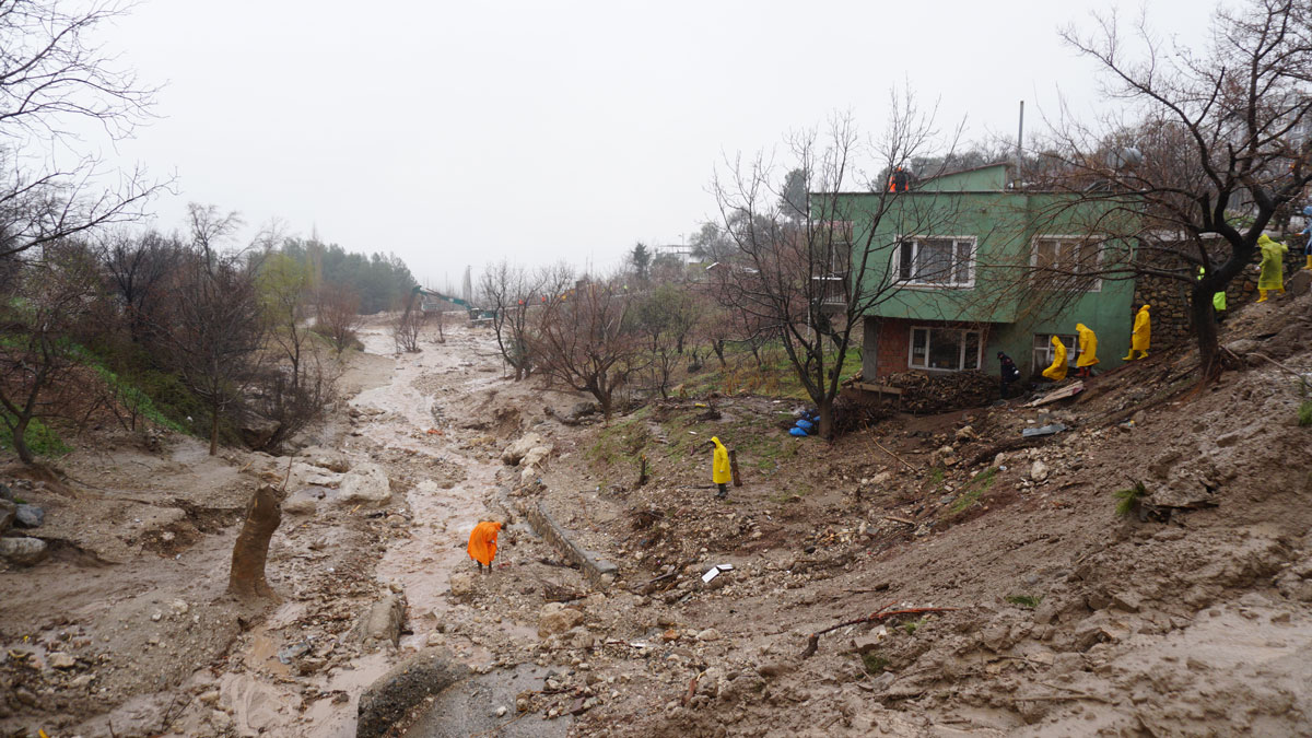
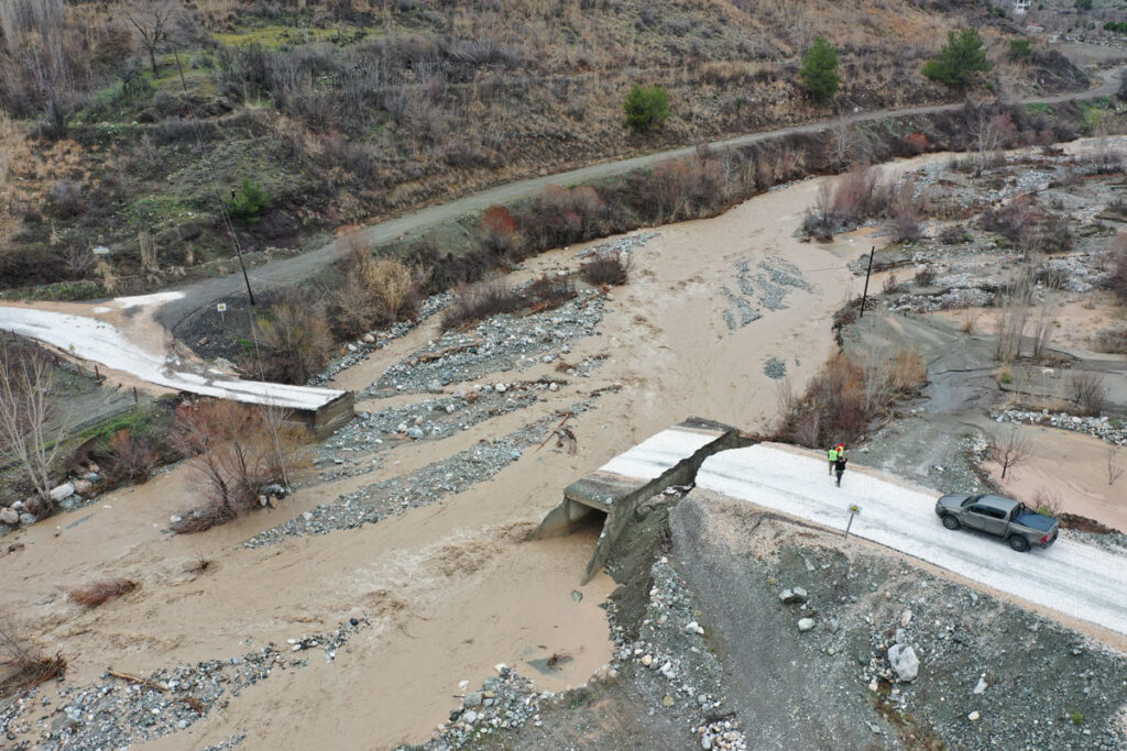
“This was the heaviest rainfall event in the area in the last 20 years,” Görüm said. In the Turkish town of Tut, the storm delivered up to 183 millimeters (7.2 inches) of rain within 20 hours. In addition, warm temperatures had caused snowmelt in the mountains just before the atmospheric river arrived, leaving the soil saturated with water and further reducing its stability.
By analyzing the strength of shaking, the steepness of the terrain, and the position of the slopes, the scientists estimated that the shear strength of hillsides—the ability of soil and rock to resist sliding when subjected to a force—in the Tut region was weakened by 52%–77%.

The consequences were severe. “The atmospheric river hit the area, triggered significant sediment movement, and killed more than 20 people,” Görüm said. Twelve of those deaths were within the study area. The resulting landslides, debris flows, and flooding also disrupted ongoing recovery efforts from the earthquake.
The catastrophe was the result of unfortunate timing. Using a computational model, the scientists ran simulations for earthquakes occurring in different seasons and tracked landslide probability over 5 years. They found that had the earthquakes occurred during summer or fall instead of winter, the recovery period wouldn’t have coincided with peak atmospheric river season, and the landslide hazard would have been significantly reduced.
Ben Leshchinsky, a civil engineer at Oregon State University who has studied cascading hazards but wasn’t involved in the research, said this study “highlights the importance of remembering there is a legacy to hazards. It’s incredibly important to keep following what happens so we can make sure we recover more quickly and plan for recovery in a smarter, more resilient way.”
Anticipating the Worst
Preparing for contemporaneous disasters might become increasingly relevant. Using 40 years of data, the researchers showed that Türkiye has experienced a significant increase in atmospheric river frequency and intensity, likely driven by climate change.
This trend extends beyond Türkiye to other seismically active regions worldwide. “On the Pacific coast [of the United States], the frequency and magnitude of atmospheric rivers is even higher than our area,” Görüm noted, adding that Southern California is seismically similar to Türkiye. These parallels suggest that lessons learned from Türkiye’s experience could help vulnerable communities around the globe develop more comprehensive disaster preparedness plans.
“This paper…reinforces the argument that we need to be thinking about these coincident hazards.”
Bruce Malamud, a geophysicist at Durham University who wasn’t involved in the study, noted that it can be dangerous when multiple hazards coincide, because government agencies focusing on different hazards work independently, so their disaster responses aren’t coordinated. “What’s important about this paper is that it reinforces the argument that we need to be thinking about these coincident hazards,” he said.
Having spent time in the disaster zone following the 2023 earthquakes, Görüm saw damaged cities and the struggles of response crews to rescue people; he understands more than most the need to warn communities of additional hazards. “It was like a nightmare,” he said.
It’s taxing to work in those conditions, he said, “but at the same time it’s quite important. You have to learn from this type of event.”
—Andrew Chapman (@andrewchapman.bsky.social), Science Writer