
In the Peruvian Amazon, deforestation is being driven by illegal gold mining, logging, and clear-cutting for cultivation of crops like palm oil and coca. Between 2001 and 2016, the Peruvian Amazon lost nearly 2 million hectares of forest.
More than one third of the Amazon rain forest falls within the territory of more than 3,000 formally acknowledged Indigenous groups, but the size and inaccessibility of Indigenous Peoples’ territory in the Amazon mean that timely alerts from satellite data can make a big difference in their existing antideforestation patrol efforts. For example, alerts can allow communities to take preventive actions, such as blocking the rivers where loggers entered.
To determine the effectiveness of timely deforestation alerts derived from recent satellite data, Indigenous Peoples in the Peruvian Amazon teamed up with scientists and conservation organizations. They analyzed deforestation rates in Indigenous communities with access to alerts about deforestation in their territory and compared them with rates from groups using other patrol methods.
The findings, published in July in the Proceedings of the National Academy of Sciences of the United States of America (PNAS), showed that from 2018 to 2020, there was a notable reduction in tree cover loss among communities with access to satellite data.
The study suggested that governments should provide Indigenous communities greater access to satellite data. “As a policymaker, you want to know: If a monitoring method works on this site, it might work somewhere else,” said Tara Slough, assistant professor of politics at New York University and lead author of the paper.
Training Locals to Monitor Forests
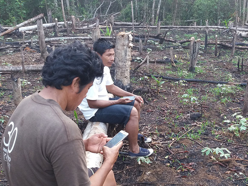
In 36 out of 73 participating Indigenous communities, researchers trained local people to use a combination of two smartphone mapping applications (Locus Map and Global Forest Watcher), with monitors receiving monthly deforestation alerts from Peru’s national GeoBosques deforestation-monitoring platform, which uses NASA’s Landsat data. They could then head out with the phone, document the problem area, see what activities were going on, and make a report to the community council.
Wendy Pineda, a project coordinator for Rainforest Foundation US—the rights-based forest protection organization that funded the research project—has been working for more than a decade to bring more high-tech monitoring tools to Indigenous communities.
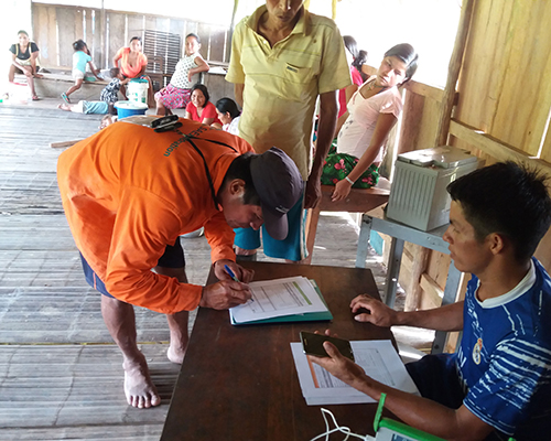
For this study, each of the noncontrol communities designed its own monitoring plan, tailored to existing and potential threats in its area. For example, a Ticuna community in Buen Jardin de Callaru that was heavily threatened by land invasion from coca farmers was encouraged to send its monitoring data of 7 hectares of deforestation to Peru’s Environmental Prosecutor’s Office. As a result, the invaders left, deforestation halted, and the community is now the beneficiary of a reforestation project.
“Indigenous Peoples have done [forest monitoring] for their entire existence and will continue to do so, only now they can be more decisive, thanks to technology.”
“Indigenous Peoples have done [forest monitoring] for their entire existence and will continue to do so, only now they can be more decisive, thanks to technology,” Pineda said. “Satellite imagery and technology…only complemented and enhanced the effectiveness of their plans.”
Jorge Perez is president of the Indigenous People’s Organization of the Eastern Amazon (ORPIO), which has long fought for land rights and preventing deforestation. ORPIO’s member communities participated in the study, and according to Perez, they are the ones who know the territory, know its problems, and feel the impacts of deforestation.
According to Perez, the satellite information aided Indigenous monitors in responding more quickly to sites where illegal deforestation was taking place. More immediate notification also allowed authorities, like the Ministry of Environment and the Environmental Prosecutor’s Office, to build the case against those engaged in illegal activity.
“Communities are experiencing the positive impacts of the intervention, so many continued to monitor even when funding ended and the pandemic began,” Pineda said.
Empirical Evidence
“Communities are experiencing the positive impacts of the intervention, so many continued to monitor even when funding ended and the pandemic began.”
Ane Alencar, director of science for the Amazon Environmental Research Institute who wasn’t involved in the PNAS study, said empirical evidence of deforestation reduction helps generate strong arguments and ideas for policymakers.
“In this case, the availability of real-time information on deforestation…seemed to end up empowering the communities to do peer enforcement,” Alencar said. Consistency is key, she warned: Over time, the effect of community empowerment may fade away if offenders perceive that there are no consequences.
One criticism of the PNAS paper is that none of the authors are from Peru, raising the specter of colonial science, in which local collaborators contribute to a major paper in a prestigious journal published by scientists from the Global North but don’t receive the academic benefits of being named as authors.
“I think it is very important to engage local actors or experts in scientific studies, since they are aware of the context and they are able to redirect and enrich any discussion or conclusion, while avoiding any possibility of misinterpretation of the results,” Alencar said.
Back in the Peruvian Amazon, Perez said he wants more climate funding, including a recent commitment from Germany, Norway, the United Kingdom, and the United States, to arrive directly to Indigenous communities to help them to continue to defend their territory.
“Even if funds run out, we are able to continue to use this knowledge,” he said.
—Andrew J. Wight (@ligaze), Science Writer
This news article is included in our ENGAGE resource for educators seeking science news for their classroom lessons. Browse all ENGAGE articles, and share with your fellow educators how you integrated the article into an activity in the comments section below.
Citation:
Wight, A. J. (2021), Indigenous Peoples harness space technology to stop deforestation, Eos, 102, https://doi.org/10.1029/2021EO162420. Published on 26 August 2021.
Text © 2021. The authors. CC BY-NC-ND 3.0
Except where otherwise noted, images are subject to copyright. Any reuse without express permission from the copyright owner is prohibited.